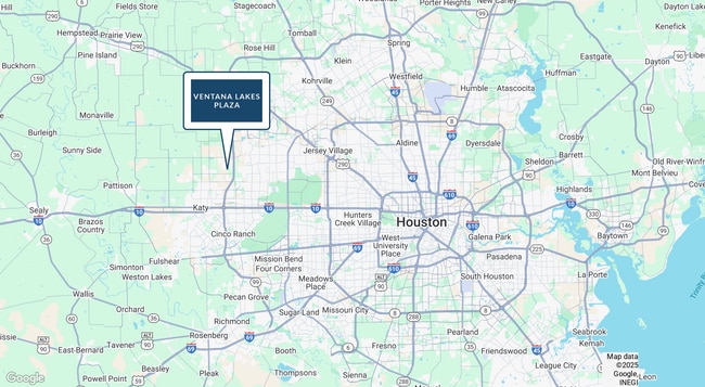
Property Record
Stockdick School Rd, Katy, TX 77493
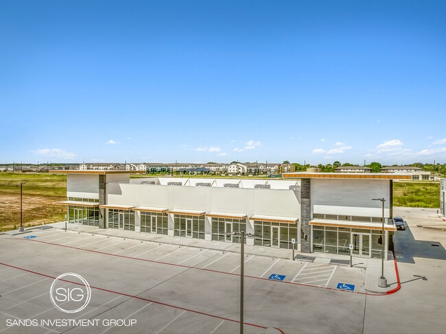

Property Detail
Stockdick School Rd
Houston-Pasadena-The Woodlands, TX
RES A BLK 1 SHOPS AT VENTANNA LAKES
1427350010001
HARRIS
Commercialacreage
Texas
2024
4.84 AC
2025
Far Katy North
542800
Houston
NEARBY LISTINGS FOR SALE OR LEASE
DEMOGRAPHICS near Stockdick School Rd
1 mile
3 mile
5 mile
2025 Total Population
6,093
74,808
245,178
2030 Population
6,956
82,707
265,922
Pop Growth 2025-2030
+ 14.16%
+ 10.56%
+ 8.46%
Average Age
32
34
35
2025 Total Households
1,803
22,106
75,637
HH Growth 2025-2030
+ 14.31%
+ 10.74%
+ 8.66%
Median Household Inc
$132,425
$110,036
$94,064
Avg Household Size
3.30
3.30
3.20
2025 Avg HH Vehicles
2.00
2.00
2.00
Median Home Value
$362,333
$309,019
$286,488
Median Year Built
2011
2011
2008
Nearby Places
Map Layers
Map Styles
 Street
 Aerial
Layers
 Traffic
 Biking
Places
Listings with unknown addresses are not visible on the map
- Restaurants
- Banks
- Shops
- Fitness
- Groceries
PUBLIC TRANSPORTATION
AIRPORT
George Bush Intcntl/Houston
Drive
Walk
Distance
George Bush Intcntl/Houston
50 min
34.0 mi
Freight Ports
Port of Houston
Drive
Walk
Distance
Port of Houston
56 min
39.7 mi
SALE & LEASE HISTORY
LISTING DATE
SALE/LEASE

Oct 10, 2025
For Sale
Nearby Properties
Address
Land Use
TOTAL SIZE
Lot Size
Zoning
Address
Land Use
TOTAL SIZE
Lot Size
Zoning
807,360 SF
54.15 AC
Address
Land Use
TOTAL SIZE
Lot Size
Zoning
838,700 SF
36.68 AC
Address
Land Use
TOTAL SIZE
Lot Size
Zoning
339,835 SF
12.09 AC
Address
Land Use
TOTAL SIZE
Lot Size
Zoning
324,201 SF
12.39 AC
Address
Land Use
TOTAL SIZE
Lot Size
Zoning
290,973 SF
15 AC
Address
Land Use
TOTAL SIZE
Lot Size
Zoning
347,834 SF
15.25 AC
Address
Land Use
TOTAL SIZE
Lot Size
Zoning
395,495 SF
13.83 AC
Address
Land Use
TOTAL SIZE
Lot Size
Zoning
292,645 SF
12.71 AC
Address
Land Use
TOTAL SIZE
Lot Size
Zoning
439,808 SF
23.75 AC
Address
Land Use
TOTAL SIZE
Lot Size
Zoning
321,565 SF
11.47 AC
Address
Land Use
TOTAL SIZE
Lot Size
Zoning
385,744 SF
25.88 AC
Address
Land Use
TOTAL SIZE
Lot Size
Zoning
151,385 SF
8.58 AC
Address
Land Use
TOTAL SIZE
Lot Size
Zoning
122,133 SF
13.46 AC
Address
Land Use
TOTAL SIZE
Lot Size
Zoning
123,466 SF
11.37 AC
Address
Land Use
TOTAL SIZE
Lot Size
Zoning
54,306 SF
3.78 AC
Address
Land Use
TOTAL SIZE
Lot Size
Zoning
193,230 SF
16.92 AC
Address
Land Use
TOTAL SIZE
Lot Size
Zoning
111,780 SF
12.75 AC
Address
Land Use
TOTAL SIZE
Lot Size
Zoning
147,923 SF
11.60 AC
Address
Land Use
TOTAL SIZE
Lot Size
Zoning
62.55 AC
Address
Land Use
TOTAL SIZE
Lot Size
Zoning
78.32 AC
Address
Land Use
TOTAL SIZE
Lot Size
Zoning
171,000 SF
7.08 AC
Address
Land Use
TOTAL SIZE
Lot Size
Zoning
119,086 SF
18.61 AC
Address
Land Use
TOTAL SIZE
Lot Size
Zoning
133,479 SF
7.46 AC
Address
Land Use
TOTAL SIZE
Lot Size
Zoning
191,575 SF
17.98 AC
Address
Land Use
TOTAL SIZE
Lot Size
Zoning
131,811 SF
29.47 AC
Address
Land Use
TOTAL SIZE
Lot Size
Zoning
122,880 SF
15 AC
Address
Land Use
TOTAL SIZE
Lot Size
Zoning
99,096 SF
27.51 AC
Address
Land Use
TOTAL SIZE
Lot Size
Zoning
143,950 SF
10.30 AC
Address
Land Use
TOTAL SIZE
Lot Size
Zoning
161,052 SF
2.73 AC
Address
Land Use
TOTAL SIZE
Lot Size
Zoning
67,250 SF
7.37 AC
The World's #1 Commercial Real Estate Marketplace
Connect with us
© 2026 CoStar Group
The information above has been obtained from sources believed reliable. While we do not doubt its accuracy we have not verified it and make no guarantee, warranty or representation about it. It is your responsibility to independently confirm its accuracy and completeness. Any projections, opinions, assumptions, or estimates used are for example only and do not represent the current or future performance of the property. The value of this transaction to you depends on tax and other factors which should be evaluated by your tax, financial, and legal advisors. You and your advisors should conduct a careful, independent investigation of the property to determine to your satisfaction the suitability of the property for your needs.