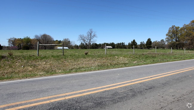
Property Record
Stockyard Rd, Siler City, NC 27344
Property Detail
Stockyard Rd
76879
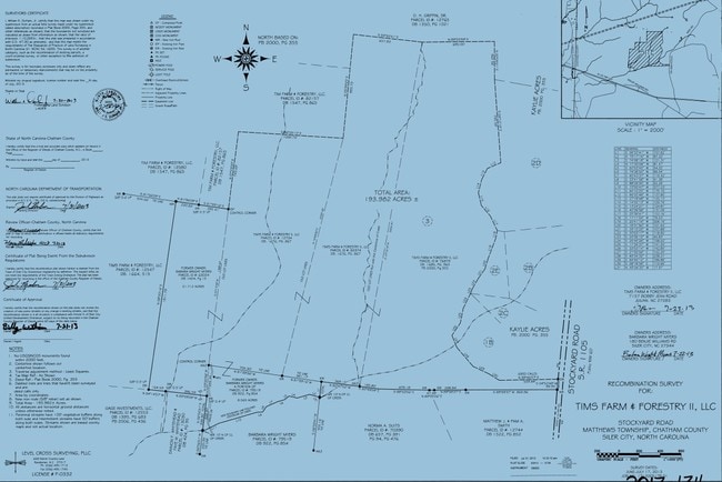
REMAINDER TR 3 AC 24.085 BK 2023 PG 43
Vacantlandnec
CHATHAM
H-I
North Carolina
B and X Area of moderate flood hazard, usually the area between the limits of the 100-year and 500-year floods.
24.09 AC
2025
Chatham County
2025
Raleigh/Durham
020401
Durham-Chapel Hill, NC
740 SF
NEARBY LISTINGS FOR SALE OR LEASE
-
-
No Photo
-
View all Siler City listings for sale on LoopNet.com
DEMOGRAPHICS near Stockyard Rd
1 mile
3 mile
5 mile
2025 Total Population
629
8,784
14,560
2030 Population
688
9,513
15,678
Pop Growth 2025-2030
+ 9.38%
+ 8.30%
+ 7.68%
Average Age
45
40
40
2025 Total Households
256
3,185
5,378
HH Growth 2025-2030
+ 9.77%
+ 8.57%
+ 7.92%
Median Household Inc
$40,114
$62,321
$56,574
Avg Household Size
2.40
2.70
2.60
2025 Avg HH Vehicles
2.00
2.00
2.00
Median Home Value
$273,809
$198,017
$194,086
Median Year Built
1983
1981
1982
Nearby Places
Map Layers
Map Styles
 Street
 Aerial
Layers
 Traffic
 Biking
Places
Listings with unknown addresses are not visible on the map
- Restaurants
- Banks
- Shops
- Fitness
- Groceries
Nearby Properties
Address
Land Use
TOTAL SIZE
Lot Size
Zoning
Address
Land Use
TOTAL SIZE
Lot Size
Zoning
713.27 AC
SCETJ
Address
Land Use
TOTAL SIZE
Lot Size
Zoning
22,416 SF
11.20 AC
R-6
Address
Land Use
TOTAL SIZE
Lot Size
Zoning
2,480 SF
13.30 AC
R-6
Address
Land Use
TOTAL SIZE
Lot Size
Zoning
1,176 SF
8.01 AC
R-10
Address
Land Use
TOTAL SIZE
Lot Size
Zoning
24,034 SF
75.66 AC
A-R
Address
Land Use
TOTAL SIZE
Lot Size
Zoning
2,480 SF
10.01 AC
SCETJ
Address
Land Use
TOTAL SIZE
Lot Size
Zoning
8,923 SF
20.75 AC
SCETJ
Address
Land Use
TOTAL SIZE
Lot Size
Zoning
72,499 SF
5.53 AC
L-I
Address
Land Use
TOTAL SIZE
Lot Size
Zoning
31,436 SF
5.36 AC
O-I
Address
Land Use
TOTAL SIZE
Lot Size
Zoning
135.57 AC
H-I
Address
Land Use
TOTAL SIZE
Lot Size
Zoning
129.52 AC
H-I
Address
Land Use
TOTAL SIZE
Lot Size
Zoning
85,596 SF
35.13 AC
H-I
Address
Land Use
TOTAL SIZE
Lot Size
Zoning
225,524 SF
21.60 AC
H-I
Address
Land Use
TOTAL SIZE
Lot Size
Zoning
82,687 SF
13.51 AC
L-I
Address
Land Use
TOTAL SIZE
Lot Size
Zoning
83,644 SF
23.50 AC
SCETJ
Address
Land Use
TOTAL SIZE
Lot Size
Zoning
24,715 SF
49.96 AC
LI-CD
Address
Land Use
TOTAL SIZE
Lot Size
Zoning
6,800 SF
5.19 AC
R-10
Address
Land Use
TOTAL SIZE
Lot Size
Zoning
25.68 AC
SCETJ
Address
Land Use
TOTAL SIZE
Lot Size
Zoning
146,215 SF
19.98 AC
H-I
Address
Land Use
TOTAL SIZE
Lot Size
Zoning
6,605 SF
3.82 AC
O-I
Address
Land Use
TOTAL SIZE
Lot Size
Zoning
229 AC
A-R
Address
Land Use
TOTAL SIZE
Lot Size
Zoning
80.60 AC
SCETJ
Address
Land Use
TOTAL SIZE
Lot Size
Zoning
10,872 SF
3.66 AC
O-I
Address
Land Use
TOTAL SIZE
Lot Size
Zoning
7,730 SF
18.76 AC
RA
Address
Land Use
TOTAL SIZE
Lot Size
Zoning
20,250 SF
21.49 AC
L-I
Address
Land Use
TOTAL SIZE
Lot Size
Zoning
13,432 SF
4 AC
H-C
Address
Land Use
TOTAL SIZE
Lot Size
Zoning
174.23 AC
SCETJ
Address
Land Use
TOTAL SIZE
Lot Size
Zoning
20,000 SF
10.11 AC
SCETJ
Address
Land Use
TOTAL SIZE
Lot Size
Zoning
1,800 SF
7.71 AC
SCETJ
Address
Land Use
TOTAL SIZE
Lot Size
Zoning
52.94 AC
A-R
The World's #1 Commercial Real Estate Marketplace
Connect with us
© 2026 CoStar Group
The information above has been obtained from sources believed reliable. While we do not doubt its accuracy we have not verified it and make no guarantee, warranty or representation about it. It is your responsibility to independently confirm its accuracy and completeness. Any projections, opinions, assumptions, or estimates used are for example only and do not represent the current or future performance of the property. The value of this transaction to you depends on tax and other factors which should be evaluated by your tax, financial, and legal advisors. You and your advisors should conduct a careful, independent investigation of the property to determine to your satisfaction the suitability of the property for your needs.