Property Record
Straub Rd, Mansfield, OH 44907


Property Detail
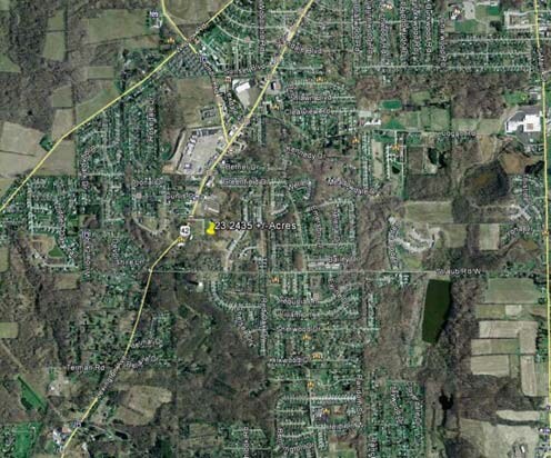
Straub Rd
Mansfield, OH
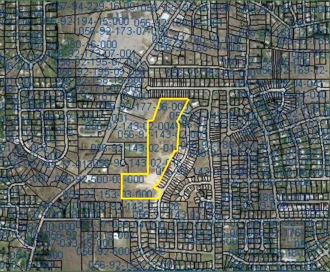
SW 10.7071 AC
056-92-143-02-003
RICHLAND
Agriculturalland
Ohio
B and X Area of moderate flood hazard, usually the area between the limits of the 100-year and 500-year floods.
10.71 AC
2024
Richland County
2024
Cleveland
001100
NEARBY LISTINGS FOR SALE OR LEASE
DEMOGRAPHICS near Straub Rd
1 mile
3 mile
5 mile
2025 Total Population
6,735
30,108
62,118
2030 Population
6,691
29,831
61,836
Pop Growth 2025-2030
(0.65%)
(0.92%)
(0.45%)
Average Age
48
44
42
2025 Total Households
3,220
13,695
27,254
HH Growth 2025-2030
(0.59%)
(0.95%)
(0.48%)
Median Household Inc
$56,436
$53,256
$51,245
Avg Household Size
2.10
2.10
2.20
2025 Avg HH Vehicles
2.00
2.00
2.00
Median Home Value
$213,468
$174,669
$162,332
Median Year Built
1975
1961
1960
Nearby Places
Map Layers
Map Styles
 Street
 Aerial
Transit
 Traffic
 Biking
Places
Listings with unknown addresses are not visible on the map
- Restaurants
- Banks
- Shops
- Fitness
- Groceries
Nearby Properties
Address
Land Use
TOTAL SIZE
Lot Size
Zoning
Address
Land Use
TOTAL SIZE
Lot Size
Zoning
492,672 SF
6.83 AC
Address
Land Use
TOTAL SIZE
Lot Size
Zoning
139,809 SF
0.99 AC
Address
Land Use
TOTAL SIZE
Lot Size
Zoning
215,214 SF
18.28 AC
Address
Land Use
TOTAL SIZE
Lot Size
Zoning
92,587 SF
48.78 AC
Address
Land Use
TOTAL SIZE
Lot Size
Zoning
32,728 SF
56.23 AC
Address
Land Use
TOTAL SIZE
Lot Size
Zoning
48,602 SF
14.66 AC
Address
Land Use
TOTAL SIZE
Lot Size
Zoning
12.96 AC
Address
Land Use
TOTAL SIZE
Lot Size
Zoning
66,940 SF
12.40 AC
Address
Land Use
TOTAL SIZE
Lot Size
Zoning
107,754 SF
3.38 AC
Address
Land Use
TOTAL SIZE
Lot Size
Zoning
76,069 SF
8 AC
Address
Land Use
TOTAL SIZE
Lot Size
Zoning
88,556 SF
12.32 AC
Address
Land Use
TOTAL SIZE
Lot Size
Zoning
2,948 SF
10.62 AC
Address
Land Use
TOTAL SIZE
Lot Size
Zoning
33,194 SF
5 AC
Address
Land Use
TOTAL SIZE
Lot Size
Zoning
188,928 SF
18.94 AC
Address
Land Use
TOTAL SIZE
Lot Size
Zoning
16,578 SF
8.23 AC
Address
Land Use
TOTAL SIZE
Lot Size
Zoning
39,696 SF
2.03 AC
Address
Land Use
TOTAL SIZE
Lot Size
Zoning
25,061 SF
4.30 AC
Address
Land Use
TOTAL SIZE
Lot Size
Zoning
78,288 SF
20.76 AC
Address
Land Use
TOTAL SIZE
Lot Size
Zoning
50,832 SF
1.64 AC
Address
Land Use
TOTAL SIZE
Lot Size
Zoning
1,035 SF
12.53 AC
Address
Land Use
TOTAL SIZE
Lot Size
Zoning
6,400 SF
7.83 AC
Address
Land Use
TOTAL SIZE
Lot Size
Zoning
94,920 SF
0.27 AC
Address
Land Use
TOTAL SIZE
Lot Size
Zoning
79,731 SF
10.43 AC
Address
Land Use
TOTAL SIZE
Lot Size
Zoning
39,168 SF
8.02 AC
Address
Land Use
TOTAL SIZE
Lot Size
Zoning
25,895 SF
2.65 AC
Address
Land Use
TOTAL SIZE
Lot Size
Zoning
32,499 SF
13.60 AC
Address
Land Use
TOTAL SIZE
Lot Size
Zoning
116,383 SF
63.86 AC
Address
Land Use
TOTAL SIZE
Lot Size
Zoning
27,040 SF
133.36 AC
Address
Land Use
TOTAL SIZE
Lot Size
Zoning
8,817 SF
2.49 AC
Address
Land Use
TOTAL SIZE
Lot Size
Zoning
27,510 SF
8.30 AC
The World's #1 Commercial Real Estate Marketplace
Connect with us
© 2026 CoStar Group
The information above has been obtained from sources believed reliable. While we do not doubt its accuracy we have not verified it and make no guarantee, warranty or representation about it. It is your responsibility to independently confirm its accuracy and completeness. Any projections, opinions, assumptions, or estimates used are for example only and do not represent the current or future performance of the property. The value of this transaction to you depends on tax and other factors which should be evaluated by your tax, financial, and legal advisors. You and your advisors should conduct a careful, independent investigation of the property to determine to your satisfaction the suitability of the property for your needs.