Property Record
Straughns Mill Rd, Oldmans, NJ 08067
Property Detail
Straughns Mill Rd
Philadelphia-Camden-Wilmington, PA-NJ-DE-MD
SALEM
07-00028-0000-00046
New Jersey
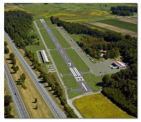
Airport
47.1
B and X Area of moderate flood hazard, usually the area between the limits of the 100-year and 500-year floods.
6.60 AC
2024
Salem County
2025
Philadelphia
020100
NEARBY LISTINGS FOR SALE OR LEASE
-
-
View all Oldmans listings for sale on LoopNet.com
DEMOGRAPHICS near Straughns Mill Rd
1 mile
3 mile
5 mile
2025 Total Population
206
8,719
35,416
2030 Population
209
8,959
36,481
Pop Growth 2025-2030
+ 1.46%
+ 2.75%
+ 3.01%
Average Age
43
41
39
2025 Total Households
76
3,231
12,588
HH Growth 2025-2030
+ 1.32%
+ 2.88%
+ 3.00%
Median Household Inc
$117,856
$118,823
$97,131
Avg Household Size
2.70
2.70
2.80
2025 Avg HH Vehicles
2.00
2.00
2.00
Median Home Value
$365,789
$348,106
$331,974
Median Year Built
1960
1988
1979
Nearby Places
Map Layers
Map Styles
 Street
 Aerial
Transit
 Traffic
 Biking
Places
Listings with unknown addresses are not visible on the map
- Restaurants
- Banks
- Shops
- Fitness
- Groceries
PUBLIC TRANSPORTATION
AIRPORT
Philadelphia International
Drive
Walk
Distance
Philadelphia International
28 min
18.4 mi
Freight Ports
Port of Wilmington, RI
Drive
Walk
Distance
Port of Wilmington, RI
29 min
18.8 mi
SALE & LEASE HISTORY
LISTING DATE
SALE/LEASE

Sep 23, 2016
For Sale
Nearby Properties
Address
Land Use
TOTAL SIZE
Lot Size
Zoning
Address
Land Use
TOTAL SIZE
Lot Size
Zoning
10,161 SF
111.60 AC
LI
Address
Land Use
TOTAL SIZE
Lot Size
Zoning
4,298 SF
61.37 AC
LI
Address
Land Use
TOTAL SIZE
Lot Size
Zoning
5,995 SF
60.16 AC
Address
Land Use
TOTAL SIZE
Lot Size
Zoning
4,817 SF
178.20 AC
Address
Land Use
TOTAL SIZE
Lot Size
Zoning
2,599 SF
24.06 AC
LI
Address
Land Use
TOTAL SIZE
Lot Size
Zoning
45.23 AC
Address
Land Use
TOTAL SIZE
Lot Size
Zoning
3,690 SF
28.15 AC
LI
Address
Land Use
TOTAL SIZE
Lot Size
Zoning
3,931 SF
72.49 AC
LI
Address
Land Use
TOTAL SIZE
Lot Size
Zoning
68.75 AC
Address
Land Use
TOTAL SIZE
Lot Size
Zoning
59.78 AC
Address
Land Use
TOTAL SIZE
Lot Size
Zoning
40.18 AC
Address
Land Use
TOTAL SIZE
Lot Size
Zoning
4,099 SF
41.90 AC
LI
Address
Land Use
TOTAL SIZE
Lot Size
Zoning
3,860 SF
29.20 AC
Address
Land Use
TOTAL SIZE
Lot Size
Zoning
3,657 SF
25.03 AC
Address
Land Use
TOTAL SIZE
Lot Size
Zoning
3,595 SF
21.40 AC
Address
Land Use
TOTAL SIZE
Lot Size
Zoning
1,925 SF
20.15 AC
Address
Land Use
TOTAL SIZE
Lot Size
Zoning
2,850 SF
18.60 AC
LI
Address
Land Use
TOTAL SIZE
Lot Size
Zoning
2,906 SF
18.70 AC
LI
Address
Land Use
TOTAL SIZE
Lot Size
Zoning
2,094 SF
88.02 AC
Address
Land Use
TOTAL SIZE
Lot Size
Zoning
1,726 SF
57.92 AC
Address
Land Use
TOTAL SIZE
Lot Size
Zoning
20.19 AC
Address
Land Use
TOTAL SIZE
Lot Size
Zoning
1,401 SF
23.22 AC
LI
Address
Land Use
TOTAL SIZE
Lot Size
Zoning
21.39 AC
Address
Land Use
TOTAL SIZE
Lot Size
Zoning
16.96 AC
Address
Land Use
TOTAL SIZE
Lot Size
Zoning
2,600 SF
25.60 AC
LI
Address
Land Use
TOTAL SIZE
Lot Size
Zoning
1,659 SF
33.03 AC
LI
Address
Land Use
TOTAL SIZE
Lot Size
Zoning
1,940 SF
75.01 AC
L1
Address
Land Use
TOTAL SIZE
Lot Size
Zoning
2,507 SF
20.14 AC
Address
Land Use
TOTAL SIZE
Lot Size
Zoning
2,032 SF
15.66 AC
LI
Address
Land Use
TOTAL SIZE
Lot Size
Zoning
2,584 SF
12.18 AC
LI
The World's #1 Commercial Real Estate Marketplace
Connect with us
© 2026 CoStar Group
The information above has been obtained from sources believed reliable. While we do not doubt its accuracy we have not verified it and make no guarantee, warranty or representation about it. It is your responsibility to independently confirm its accuracy and completeness. Any projections, opinions, assumptions, or estimates used are for example only and do not represent the current or future performance of the property. The value of this transaction to you depends on tax and other factors which should be evaluated by your tax, financial, and legal advisors. You and your advisors should conduct a careful, independent investigation of the property to determine to your satisfaction the suitability of the property for your needs.