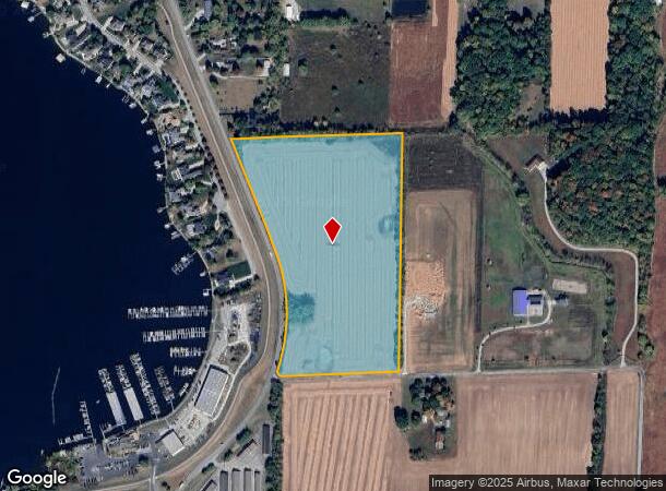
Property Record
Stringtown Pike, Noblesville, IN 46062
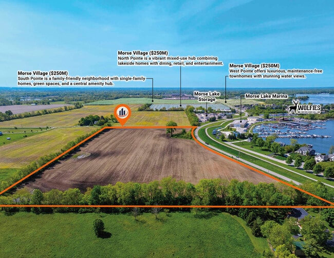
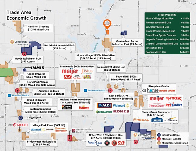
This Property Is For Sale
NEARBY LISTINGS FOR SALE OR LEASE
-
-
View all Noblesville listings for sale on LoopNet.com
Property Detail
Stringtown Pike
Indianapolis-Carmel-Anderson, IN
Noblesville Twp
29-06-13-000-025.000-012
ACREAGE 22.60, SECTION 13, TOWNSHIP 19, RANGE 4
Agriculturalland
Hamilton
X
Indiana
18057C0132H
22.60 AC
2023
Far North Hamilton Cnty
2024
Indianapolis
110518
DEMOGRAPHICS near Stringtown Pike
1 Mile
3 Mile
5 Mile
2024 Total Population
2,989
28,069
60,724
2029 Population
3,179
29,928
65,158
Pop Growth 2024-2029
+ 6.36%
+ 6.62%
+ 7.30%
Average Age
44
41
40
2024 Total Households
1,162
10,594
23,099
HH Growth 2024-2029
+ 6.37%
+ 6.74%
+ 7.45%
Median Household Inc
$121,361
$112,085
$105,531
Avg Household Size
2.50
2.60
2.60
2024 Avg HH Vehicles
2.00
2.00
2.00
Median Home Value
$446,761
$371,697
$359,100
Median Year Built
1990
1993
1994
Nearby Places
- Restaurants
- Banks
- Shops
- Fitness
- Groceries
PUBLIC TRANSPORTATION
AIRPORT
Indianapolis International
DRIVE
WALK
Distance
Indianapolis International
67 min
42.1 mi
Freight Ports
Port of Toledo
DRIVE
WALK
Distance
Port of Toledo
256 min
203.8 mi
Nearby Properties
Address
Land Use
TOTAL SIZE
Lot Size
Zoning
Address
Land Use
TOTAL SIZE
Lot Size
Zoning
317,049 SF
38.45 AC
Address
Land Use
TOTAL SIZE
Lot Size
Zoning
451,226 SF
30.53 AC
Address
Land Use
TOTAL SIZE
Lot Size
Zoning
102,021 SF
28.66 AC
Address
Land Use
TOTAL SIZE
Lot Size
Zoning
86,933 SF
5 AC
Address
Land Use
TOTAL SIZE
Lot Size
Zoning
99,590 SF
8.50 AC
Address
Land Use
TOTAL SIZE
Lot Size
Zoning
103,216 SF
6.99 AC
Address
Land Use
TOTAL SIZE
Lot Size
Zoning
100,824 SF
7.61 AC
Address
Land Use
TOTAL SIZE
Lot Size
Zoning
45,935 SF
2.75 AC
Address
Land Use
TOTAL SIZE
Lot Size
Zoning
49,244 SF
3.76 AC
Address
Land Use
TOTAL SIZE
Lot Size
Zoning
50,398 SF
3.47 AC
Address
Land Use
TOTAL SIZE
Lot Size
Zoning
35,825 SF
19.35 AC
Address
Land Use
TOTAL SIZE
Lot Size
Zoning
77,894 SF
1.56 AC
Address
Land Use
TOTAL SIZE
Lot Size
Zoning
29,150 SF
9.46 AC
Address
Land Use
TOTAL SIZE
Lot Size
Zoning
12,029 SF
36.20 AC
Address
Land Use
TOTAL SIZE
Lot Size
Zoning
12,406 SF
5 AC
Address
Land Use
TOTAL SIZE
Lot Size
Zoning
45,646 SF
8.53 AC
Address
Land Use
TOTAL SIZE
Lot Size
Zoning
13,351 SF
2.08 AC
Address
Land Use
TOTAL SIZE
Lot Size
Zoning
48,000 SF
20 AC
Address
Land Use
TOTAL SIZE
Lot Size
Zoning
24,698 SF
41.23 AC
Address
Land Use
TOTAL SIZE
Lot Size
Zoning
33,846 SF
2.30 AC
Address
Land Use
TOTAL SIZE
Lot Size
Zoning
59,570 SF
6.98 AC
Address
Land Use
TOTAL SIZE
Lot Size
Zoning
35,980 SF
5.05 AC
Address
Land Use
TOTAL SIZE
Lot Size
Zoning
16,184 SF
8.17 AC
Address
Land Use
TOTAL SIZE
Lot Size
Zoning
14,433 SF
2.56 AC
Address
Land Use
TOTAL SIZE
Lot Size
Zoning
50,716 SF
7.17 AC
Address
Land Use
TOTAL SIZE
Lot Size
Zoning
10,224 SF
5.17 AC
Address
Land Use
TOTAL SIZE
Lot Size
Zoning
36,000 SF
9.45 AC
Address
Land Use
TOTAL SIZE
Lot Size
Zoning
1,232 SF
333.30 AC
Address
Land Use
TOTAL SIZE
Lot Size
Zoning
17,720 SF
1.88 AC
Address
Land Use
TOTAL SIZE
Lot Size
Zoning
8,560 SF
50 AC
The World's #1 Commercial Real Estate Marketplace
Connect with us
© 2025 CoStar Group
The information above has been obtained from sources believed reliable. While we do not doubt its accuracy we have not verified it and make no guarantee, warranty or representation about it. It is your responsibility to independently confirm its accuracy and completeness. Any projections, opinions, assumptions, or estimates used are for example only and do not represent the current or future performance of the property. The value of this transaction to you depends on tax and other factors which should be evaluated by your tax, financial, and legal advisors. You and your advisors should conduct a careful, independent investigation of the property to determine to your satisfaction the suitability of the property for your needs.