Property Record
5294 Access Undetermined Way, Fort Myers, FL 33907

NEARBY LISTINGS FOR SALE OR LEASE
Property Detail
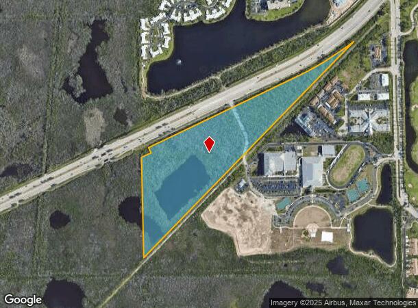
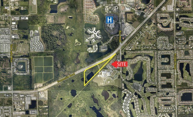
5294 Access Undetermined Way
Cape Coral-Fort Myers, FL
Summerlin Rd Corridor
04-46-24-00-00008.0000
SW 1/4 N OF RR AND S OF PROPOSED S R 869 LESS PARL 8.0020
Commercialacreage
Lee
AE
Florida
12071C0556G
25.64 AC
2024
S Ft Myers/San Carlos
2025
Southwest Florida
001502
DEMOGRAPHICS near 5294 Access Undetermined Way
1 Mile
3 Mile
5 Mile
2024 Total Population
4,350
47,313
101,652
2029 Population
5,224
56,721
121,516
Pop Growth 2024-2029
+ 20.09%
+ 19.88%
+ 19.54%
Average Age
61
56
55
2024 Total Households
2,000
23,693
51,317
HH Growth 2024-2029
+ 20.15%
+ 19.66%
+ 19.24%
Median Household Inc
$65,560
$62,870
$62,424
Avg Household Size
1.90
1.90
1.90
2024 Avg HH Vehicles
1.00
1.00
1.00
Median Home Value
$314,669
$276,463
$287,081
Median Year Built
1999
1996
1988
Nearby Places
- Restaurants
- Banks
- Shops
- Fitness
- Groceries
PUBLIC TRANSPORTATION
AIRPORT
Southwest Florida International
DRIVE
WALK
Distance
Southwest Florida International
23 min
12.8 mi
Punta Gorda
DRIVE
WALK
Distance
Punta Gorda
51 min
38.9 mi
Freight Ports
Port Manatee
DRIVE
WALK
Distance
Port Manatee
131 min
110.6 mi
SALE & LEASE HISTORY
LISTING DATE
SALE/LEASE

Sep 24, 2016
For Sale
Dec 07, 2016
For Sale
Nearby Properties
Address
Land Use
TOTAL SIZE
Lot Size
Zoning
Address
Land Use
TOTAL SIZE
Lot Size
Zoning
1,116,051 SF
35.44 AC
CPD
Address
Land Use
TOTAL SIZE
Lot Size
Zoning
Address
Land Use
TOTAL SIZE
Lot Size
Zoning
562,104 SF
18.98 AC
RPD
Address
Land Use
TOTAL SIZE
Lot Size
Zoning
446,205 SF
28.90 AC
CC
Address
Land Use
TOTAL SIZE
Lot Size
Zoning
564,663 SF
33.53 AC
CPD
Address
Land Use
TOTAL SIZE
Lot Size
Zoning
423,044 SF
37.11 AC
C-1
Address
Land Use
TOTAL SIZE
Lot Size
Zoning
335,660 SF
15.42 AC
MPD
Address
Land Use
TOTAL SIZE
Lot Size
Zoning
209,483 SF
15.03 AC
CF-2
Address
Land Use
TOTAL SIZE
Lot Size
Zoning
9,670 SF
9.12 AC
AG-2
Address
Land Use
TOTAL SIZE
Lot Size
Zoning
153,907 SF
22.03 AC
TFC2
Address
Land Use
TOTAL SIZE
Lot Size
Zoning
96,448 SF
3.85 AC
CPD
Address
Land Use
TOTAL SIZE
Lot Size
Zoning
469,746 SF
89.45 AC
RPD
Address
Land Use
TOTAL SIZE
Lot Size
Zoning
65,051 SF
4.89 AC
CFPD
Address
Land Use
TOTAL SIZE
Lot Size
Zoning
301,212 SF
5.28 AC
Address
Land Use
TOTAL SIZE
Lot Size
Zoning
15.22 AC
CF-3
Address
Land Use
TOTAL SIZE
Lot Size
Zoning
84,147 SF
10.60 AC
CPD
Address
Land Use
TOTAL SIZE
Lot Size
Zoning
89,321 SF
11.40 AC
CPD
Address
Land Use
TOTAL SIZE
Lot Size
Zoning
5,654 SF
49.94 AC
MH-2
Address
Land Use
TOTAL SIZE
Lot Size
Zoning
13.65 AC
CPD
Address
Land Use
TOTAL SIZE
Lot Size
Zoning
11.29 AC
CPD
Address
Land Use
TOTAL SIZE
Lot Size
Zoning
132,456 SF
7.86 AC
IPD
Address
Land Use
TOTAL SIZE
Lot Size
Zoning
38,928 SF
4.88 AC
CT
Address
Land Use
TOTAL SIZE
Lot Size
Zoning
34,157 SF
2.54 AC
CPD
Address
Land Use
TOTAL SIZE
Lot Size
Zoning
44.05 AC
RPD
Address
Land Use
TOTAL SIZE
Lot Size
Zoning
185,986 SF
13.40 AC
CPD
Address
Land Use
TOTAL SIZE
Lot Size
Zoning
82,450 SF
4.11 AC
CPD
Address
Land Use
TOTAL SIZE
Lot Size
Zoning
6,910 SF
7.37 AC
AG-2
Address
Land Use
TOTAL SIZE
Lot Size
Zoning
59,183 SF
7.16 AC
CPD
Address
Land Use
TOTAL SIZE
Lot Size
Zoning
79,935 SF
16.25 AC
CPD
Address
Land Use
TOTAL SIZE
Lot Size
Zoning
61,929 SF
5.73 AC
CPD
The World's #1 Commercial Real Estate Marketplace
Connect with us
© 2025 CoStar Group
The information above has been obtained from sources believed reliable. While we do not doubt its accuracy we have not verified it and make no guarantee, warranty or representation about it. It is your responsibility to independently confirm its accuracy and completeness. Any projections, opinions, assumptions, or estimates used are for example only and do not represent the current or future performance of the property. The value of this transaction to you depends on tax and other factors which should be evaluated by your tax, financial, and legal advisors. You and your advisors should conduct a careful, independent investigation of the property to determine to your satisfaction the suitability of the property for your needs.