Property Record
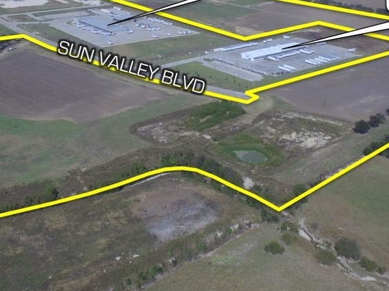
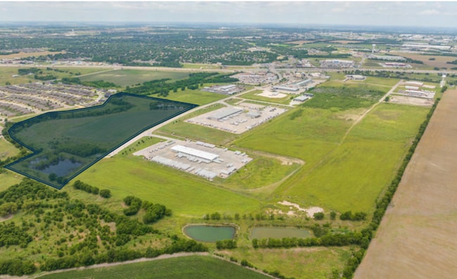
Sun Valley Blvd, Waco, TX 76706

This Property Is For Sale
Property Detail
Sun Valley Blvd
Waco, TX
OCAMPO C ACRES 61.304
44-003200-016709-0
MCLENNAN
Privatepreserveopenspacevacantlandforestlandconservation
Texas
R
45
AE The base floodplain where base flood elevations are provided. AE Zones are now used on new format FIRMs instead of A1-A30 Zones.
61.30 AC
2024
Waco
2025
Other Market Areas
002100
NEARBY LISTINGS FOR SALE OR LEASE
DEMOGRAPHICS near Sun Valley Blvd
1 mile
3 mile
5 mile
2025 Total Population
2,438
22,564
63,131
2030 Population
2,501
23,275
65,293
Pop Growth 2025-2030
+ 2.58%
+ 3.15%
+ 3.42%
Average Age
38
39
39
2025 Total Households
867
8,511
23,757
HH Growth 2025-2030
+ 2.65%
+ 3.14%
+ 3.44%
Median Household Inc
$105,040
$93,330
$80,200
Avg Household Size
2.80
2.60
2.60
2025 Avg HH Vehicles
2.00
2.00
2.00
Median Home Value
$332,424
$290,489
$283,890
Median Year Built
1999
1998
1990
Nearby Places
Map Layers
Map Styles
 Street
 Aerial
Layers
 Traffic
 Biking
Places
Listings with unknown addresses are not visible on the map
- Restaurants
- Banks
- Shops
- Fitness
- Groceries
PUBLIC TRANSPORTATION
AIRPORT
Waco Regional
Drive
Walk
Distance
Waco Regional
29 min
15.8 mi
Freight Ports
Port of Houston
Drive
Walk
Distance
Port of Houston
221 min
191.1 mi
Nearby Properties
Address
Land Use
TOTAL SIZE
Lot Size
Zoning
Address
Land Use
TOTAL SIZE
Lot Size
Zoning
Address
Land Use
TOTAL SIZE
Lot Size
Zoning
Address
Land Use
TOTAL SIZE
Lot Size
Zoning
108,521 SF
70.78 AC
Address
Land Use
TOTAL SIZE
Lot Size
Zoning
78.95 AC
Address
Land Use
TOTAL SIZE
Lot Size
Zoning
752,540 SF
96.04 AC
M-2
Address
Land Use
TOTAL SIZE
Lot Size
Zoning
285,829 SF
17.35 AC
Address
Land Use
TOTAL SIZE
Lot Size
Zoning
279,135 SF
13 AC
Address
Land Use
TOTAL SIZE
Lot Size
Zoning
674,900 SF
87.44 AC
M2
Address
Land Use
TOTAL SIZE
Lot Size
Zoning
106,633 SF
1.98 AC
C2
Address
Land Use
TOTAL SIZE
Lot Size
Zoning
34,723 SF
0.72 AC
Address
Land Use
TOTAL SIZE
Lot Size
Zoning
459,747 SF
36.13 AC
M2
Address
Land Use
TOTAL SIZE
Lot Size
Zoning
70.76 AC
O2
Address
Land Use
TOTAL SIZE
Lot Size
Zoning
219,544 SF
23.11 AC
Address
Land Use
TOTAL SIZE
Lot Size
Zoning
99,179 SF
54.16 AC
R1
Address
Land Use
TOTAL SIZE
Lot Size
Zoning
Address
Land Use
TOTAL SIZE
Lot Size
Zoning
87,492 SF
29.99 AC
R1
Address
Land Use
TOTAL SIZE
Lot Size
Zoning
59,334 SF
0.59 AC
C2
Address
Land Use
TOTAL SIZE
Lot Size
Zoning
74,786 SF
2.28 AC
C2
Address
Land Use
TOTAL SIZE
Lot Size
Zoning
12,658 SF
115.68 AC
M1
Address
Land Use
TOTAL SIZE
Lot Size
Zoning
169,278 SF
19.14 AC
R1
Address
Land Use
TOTAL SIZE
Lot Size
Zoning
400.45 AC
R
Address
Land Use
TOTAL SIZE
Lot Size
Zoning
76,872 SF
2.14 AC
C2
Address
Land Use
TOTAL SIZE
Lot Size
Zoning
134,265 SF
13.50 AC
M2
Address
Land Use
TOTAL SIZE
Lot Size
Zoning
150,212 SF
16.79 AC
Address
Land Use
TOTAL SIZE
Lot Size
Zoning
162,693 SF
17.63 AC
Address
Land Use
TOTAL SIZE
Lot Size
Zoning
100,482 SF
4.50 AC
O2
Address
Land Use
TOTAL SIZE
Lot Size
Zoning
208,629 SF
49.69 AC
M2
Address
Land Use
TOTAL SIZE
Lot Size
Zoning
71,951 SF
3.62 AC
C2
Address
Land Use
TOTAL SIZE
Lot Size
Zoning
156,531 SF
7.51 AC
R-4
Address
Land Use
TOTAL SIZE
Lot Size
Zoning
77,188 SF
6.62 AC
The World's #1 Commercial Real Estate Marketplace
Connect with us
© 2026 CoStar Group
The information above has been obtained from sources believed reliable. While we do not doubt its accuracy we have not verified it and make no guarantee, warranty or representation about it. It is your responsibility to independently confirm its accuracy and completeness. Any projections, opinions, assumptions, or estimates used are for example only and do not represent the current or future performance of the property. The value of this transaction to you depends on tax and other factors which should be evaluated by your tax, financial, and legal advisors. You and your advisors should conduct a careful, independent investigation of the property to determine to your satisfaction the suitability of the property for your needs.