Property Record
Sunburst Dr, Joshua Tree, CA 92252


Property Detail
Sunburst Dr
0601-211-09
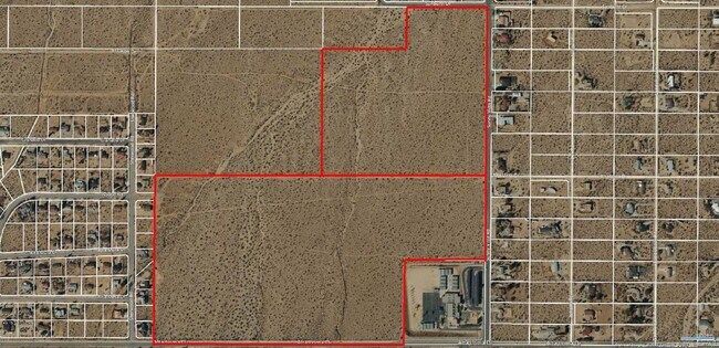
NE 1/4 SE 1/4 SEC 34 TP 1N R 6E EX N 1/2 NW 1/4 NE 1/4 SE 1/4 AND EX CO RD
Vacantlandnec
SAN BERNARDINO
JTRS10M
California
B and X Area of moderate flood hazard, usually the area between the limits of the 100-year and 500-year floods.
34.39 AC
2025
Twentynine Palms
2025
Inland Empire (California)
010420
Riverside-San Bernardino-Ontario, CA
NEARBY LISTINGS FOR SALE OR LEASE
DEMOGRAPHICS near Sunburst Dr
1 mile
3 mile
5 mile
2025 Total Population
1,996
9,342
22,755
2030 Population
2,105
9,792
23,662
Pop Growth 2025-2030
+ 5.46%
+ 4.82%
+ 3.99%
Average Age
43
42
42
2025 Total Households
852
3,879
9,209
HH Growth 2025-2030
+ 5.40%
+ 4.92%
+ 4.07%
Median Household Inc
$113,481
$67,807
$67,996
Avg Household Size
2.30
2.30
2.40
2025 Avg HH Vehicles
2.00
2.00
2.00
Median Home Value
$506,345
$361,417
$380,301
Median Year Built
1985
1980
1981
Nearby Places
Map Layers
Map Styles
 Street
 Aerial
Layers
 Traffic
 Biking
Places
Listings with unknown addresses are not visible on the map
- Restaurants
- Banks
- Shops
- Fitness
- Groceries
PUBLIC TRANSPORTATION
AIRPORT
Palm Springs International
Drive
Walk
Distance
Palm Springs International
50 min
36.4 mi
Freight Ports
Port of Long Beach
Drive
Walk
Distance
Port of Long Beach
162 min
128.3 mi
SALE & LEASE HISTORY
LISTING DATE
SALE/LEASE

Dec 23, 2016
For Sale
Apr 20, 2020
For Sale
Nearby Properties
Address
Land Use
TOTAL SIZE
Lot Size
Zoning
Address
Land Use
TOTAL SIZE
Lot Size
Zoning
196,781 SF
23.85 AC
Address
Land Use
TOTAL SIZE
Lot Size
Zoning
102,500 SF
13.07 AC
Address
Land Use
TOTAL SIZE
Lot Size
Zoning
31,345 SF
10.12 AC
Address
Land Use
TOTAL SIZE
Lot Size
Zoning
70,829 SF
4.55 AC
JTRM
Address
Land Use
TOTAL SIZE
Lot Size
Zoning
24,693 SF
2.31 AC
Address
Land Use
TOTAL SIZE
Lot Size
Zoning
7,668 SF
0.99 AC
Address
Land Use
TOTAL SIZE
Lot Size
Zoning
9,100 SF
1.14 AC
JTCGSCP
Address
Land Use
TOTAL SIZE
Lot Size
Zoning
10,064 SF
0.88 AC
Address
Land Use
TOTAL SIZE
Lot Size
Zoning
13,696 SF
2.13 AC
Address
Land Use
TOTAL SIZE
Lot Size
Zoning
41,585 SF
4.19 AC
JTRM
Address
Land Use
TOTAL SIZE
Lot Size
Zoning
Address
Land Use
TOTAL SIZE
Lot Size
Zoning
11,548 SF
4.82 AC
Address
Land Use
TOTAL SIZE
Lot Size
Zoning
24,256 SF
0.82 AC
JTRM
Address
Land Use
TOTAL SIZE
Lot Size
Zoning
3,525 SF
13.07 AC
Address
Land Use
TOTAL SIZE
Lot Size
Zoning
11,016 SF
6.76 AC
JTRS14M
Address
Land Use
TOTAL SIZE
Lot Size
Zoning
178,160 SF
4.09 AC
JTRM
Address
Land Use
TOTAL SIZE
Lot Size
Zoning
736 SF
8.22 AC
JTRM
Address
Land Use
TOTAL SIZE
Lot Size
Zoning
5,091 SF
0.61 AC
Address
Land Use
TOTAL SIZE
Lot Size
Zoning
130.75 AC
JTRS10M
Address
Land Use
TOTAL SIZE
Lot Size
Zoning
3,200 SF
0.90 AC
Address
Land Use
TOTAL SIZE
Lot Size
Zoning
2,714 SF
0.84 AC
Address
Land Use
TOTAL SIZE
Lot Size
Zoning
320.08 AC
Address
Land Use
TOTAL SIZE
Lot Size
Zoning
2,421 SF
0.84 AC
Address
Land Use
TOTAL SIZE
Lot Size
Zoning
51.52 AC
JTRS10M
Address
Land Use
TOTAL SIZE
Lot Size
Zoning
2,690 SF
5 AC
JTRL
Address
Land Use
TOTAL SIZE
Lot Size
Zoning
70,829 SF
2.60 AC
JTRM
Address
Land Use
TOTAL SIZE
Lot Size
Zoning
19.61 AC
Address
Land Use
TOTAL SIZE
Lot Size
Zoning
8,239 SF
1.33 AC
JTRM
Address
Land Use
TOTAL SIZE
Lot Size
Zoning
19,632 SF
2.01 AC
926
Address
Land Use
TOTAL SIZE
Lot Size
Zoning
8,605 SF
5.36 AC
The World's #1 Commercial Real Estate Marketplace
Connect with us
© 2026 CoStar Group
The information above has been obtained from sources believed reliable. While we do not doubt its accuracy we have not verified it and make no guarantee, warranty or representation about it. It is your responsibility to independently confirm its accuracy and completeness. Any projections, opinions, assumptions, or estimates used are for example only and do not represent the current or future performance of the property. The value of this transaction to you depends on tax and other factors which should be evaluated by your tax, financial, and legal advisors. You and your advisors should conduct a careful, independent investigation of the property to determine to your satisfaction the suitability of the property for your needs.