Property Record
Salem Rd, Burlington, NJ 08016

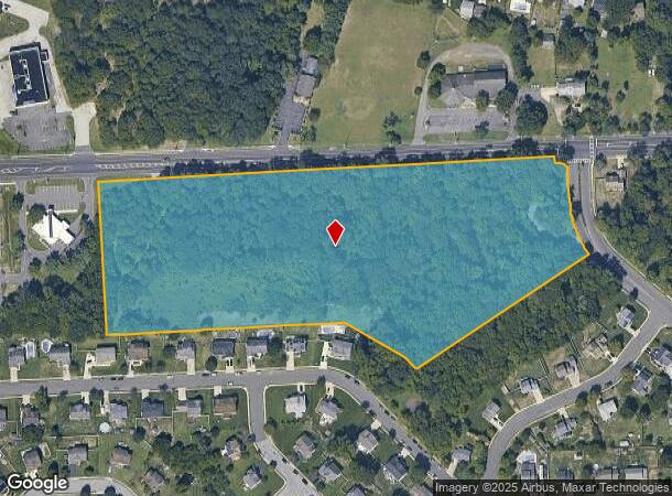

This Property Is For Sale
NEARBY LISTINGS FOR SALE OR LEASE
Property Detail
Salem Rd
Philadelphia-Camden-Wilmington, PA-NJ-DE-MD
Incl
06-00105-0000-00005
Burlington
Vacantlandnec
New Jersey
X
5
34005C0136F
12.19 AC
2024
North Burlington County
2025
Philadelphia
701201
DEMOGRAPHICS near Salem Rd
1 Mile
3 Mile
5 Mile
2024 Total Population
10,879
71,994
156,596
2029 Population
11,066
73,263
158,669
Pop Growth 2024-2029
+ 1.72%
+ 1.76%
+ 1.32%
Average Age
40
41
41
2024 Total Households
3,828
26,679
58,214
HH Growth 2024-2029
+ 1.70%
+ 1.80%
+ 1.32%
Median Household Inc
$82,764
$84,885
$85,512
Avg Household Size
2.80
2.60
2.60
2024 Avg HH Vehicles
2.00
2.00
2.00
Median Home Value
$251,129
$225,147
$252,201
Median Year Built
1968
1965
1966
Nearby Places
- Restaurants
- Banks
- Shops
- Fitness
- Groceries
PUBLIC TRANSPORTATION
COMMUTER RAIL
Bristol (R7 - Southeastern Pennsylvania Transportation Authority Regional Rail (SEPTA Regional Rail))
DRIVE
WALK
Distance
Bristol (R7 - Southeastern Pennsylvania Transportation Authority Regional Rail (SEPTA Regional Rail))
12 min
5.3 mi
Croydon (R7 - Southeastern Pennsylvania Transportation Authority Regional Rail (SEPTA Regional Rail))
DRIVE
WALK
Distance
Croydon (R7 - Southeastern Pennsylvania Transportation Authority Regional Rail (SEPTA Regional Rail))
13 min
5.8 mi
AIRPORT
Trenton Mercer
DRIVE
WALK
Distance
Trenton Mercer
34 min
20.1 mi
Philadelphia International
DRIVE
WALK
Distance
Philadelphia International
46 min
27.9 mi
Freight Ports
Port of Philadelphia
DRIVE
WALK
Distance
Port of Philadelphia
27 min
15.5 mi
Nearby Properties
Address
Land Use
TOTAL SIZE
Lot Size
Zoning
Address
Land Use
TOTAL SIZE
Lot Size
Zoning
2,183 SF
61.10 AC
Address
Land Use
TOTAL SIZE
Lot Size
Zoning
2,614 SF
55.41 AC
R40
Address
Land Use
TOTAL SIZE
Lot Size
Zoning
Address
Land Use
TOTAL SIZE
Lot Size
Zoning
39.18 AC
Address
Land Use
TOTAL SIZE
Lot Size
Zoning
14.82 AC
Address
Land Use
TOTAL SIZE
Lot Size
Zoning
97,993 SF
63.75 AC
Address
Land Use
TOTAL SIZE
Lot Size
Zoning
30.76 AC
R-9
Address
Land Use
TOTAL SIZE
Lot Size
Zoning
26.12 AC
B-2
Address
Land Use
TOTAL SIZE
Lot Size
Zoning
58.39 AC
B-2
Address
Land Use
TOTAL SIZE
Lot Size
Zoning
682,707 SF
Address
Land Use
TOTAL SIZE
Lot Size
Zoning
Address
Land Use
TOTAL SIZE
Lot Size
Zoning
22,688 SF
32.55 AC
BLI1
Address
Land Use
TOTAL SIZE
Lot Size
Zoning
Address
Land Use
TOTAL SIZE
Lot Size
Zoning
35.90 AC
R-40
Address
Land Use
TOTAL SIZE
Lot Size
Zoning
Address
Land Use
TOTAL SIZE
Lot Size
Zoning
29.76 AC
R-40
Address
Land Use
TOTAL SIZE
Lot Size
Zoning
Address
Land Use
TOTAL SIZE
Lot Size
Zoning
32.72 AC
Address
Land Use
TOTAL SIZE
Lot Size
Zoning
18.77 AC
Address
Land Use
TOTAL SIZE
Lot Size
Zoning
Address
Land Use
TOTAL SIZE
Lot Size
Zoning
376 SF
32.32 AC
B-3
Address
Land Use
TOTAL SIZE
Lot Size
Zoning
16.23 AC
R-3
Address
Land Use
TOTAL SIZE
Lot Size
Zoning
15.09 AC
Address
Land Use
TOTAL SIZE
Lot Size
Zoning
308 SF
24.29 AC
BLI1
Address
Land Use
TOTAL SIZE
Lot Size
Zoning
190,000 SF
22.17 AC
Address
Land Use
TOTAL SIZE
Lot Size
Zoning
253,500 SF
24.28 AC
BLI1
Address
Land Use
TOTAL SIZE
Lot Size
Zoning
266,966 SF
39.90 AC
I-1
Address
Land Use
TOTAL SIZE
Lot Size
Zoning
1,325 SF
18.73 AC
Address
Land Use
TOTAL SIZE
Lot Size
Zoning
217,986 SF
39.89 AC
I-1
Address
Land Use
TOTAL SIZE
Lot Size
Zoning
9.65 AC
The World's #1 Commercial Real Estate Marketplace
Connect with us
© 2025 CoStar Group
The information above has been obtained from sources believed reliable. While we do not doubt its accuracy we have not verified it and make no guarantee, warranty or representation about it. It is your responsibility to independently confirm its accuracy and completeness. Any projections, opinions, assumptions, or estimates used are for example only and do not represent the current or future performance of the property. The value of this transaction to you depends on tax and other factors which should be evaluated by your tax, financial, and legal advisors. You and your advisors should conduct a careful, independent investigation of the property to determine to your satisfaction the suitability of the property for your needs.