Property Record
G10 Stw Vic Ave, Lancaster, CA 93536
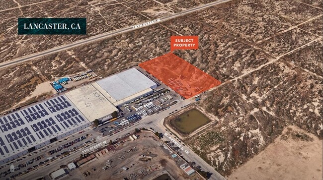

Property Detail
G10 Stw Vic Ave
Los Angeles-Long Beach-Glendale, CA
RECORD OF SURVEY AS PER BK 64 PG 16-17 OF R S N 1/2 OF LOT 21
3118-012-004
LOS ANGELES
Residentialacreage
California
LRHI
21
AO River or stream flood hazard areas, and areas with a 1% or greater chance of shallow flooding each year. These areas have a 26% chance of flooding over the life of a 30-year mortgage.
5 AC
2024
Antelope Valley
2025
Los Angeles
901214
NEARBY LISTINGS FOR SALE OR LEASE
DEMOGRAPHICS near G10 Stw Vic Ave
1 mile
3 mile
5 mile
2025 Total Population
4,412
57,619
147,400
2030 Population
4,335
57,372
147,751
Pop Growth 2025-2030
(1.75%)
(0.43%)
+ 0.24%
Average Age
36
37
37
2025 Total Households
1,228
18,138
47,038
HH Growth 2025-2030
(2.04%)
(0.46%)
+ 0.35%
Median Household Inc
$67,735
$60,100
$69,852
Avg Household Size
3.40
3.00
3.00
2025 Avg HH Vehicles
2.00
2.00
2.00
Median Home Value
$369,148
$344,658
$402,785
Median Year Built
1982
1978
1984
Nearby Places
Map Layers
Map Styles
 Street
 Aerial
Layers
 Traffic
 Biking
Places
Listings with unknown addresses are not visible on the map
- Restaurants
- Banks
- Shops
- Fitness
- Groceries
PUBLIC TRANSPORTATION
COMMUTER RAIL
Lancaster (Antelope Valley Line - Southern California Regional Rail Authority (Metrolink))
Drive
Walk
Distance
Lancaster (Antelope Valley Line - Southern California Regional Rail Authority (Metrolink))
4 min
2.1 mi
Palmdale (Antelope Valley Line - Southern California Regional Rail Authority (Metrolink))
Drive
Walk
Distance
Palmdale (Antelope Valley Line - Southern California Regional Rail Authority (Metrolink))
16 min
9.9 mi
Freight Ports
Port of Long Beach
Drive
Walk
Distance
Port of Long Beach
113 min
97.1 mi
SALE & LEASE HISTORY
LISTING DATE
SALE/LEASE

Nov 15, 2024
For Sale
Nearby Properties
Address
Land Use
TOTAL SIZE
Lot Size
Zoning
Address
Land Use
TOTAL SIZE
Lot Size
Zoning
2,922,905 SF
85.01 AC
LRLI
Address
Land Use
TOTAL SIZE
Lot Size
Zoning
153,117 SF
14.12 AC
LRSP80-01*
Address
Land Use
TOTAL SIZE
Lot Size
Zoning
552,178 SF
17.77 AC
LRHI*
Address
Land Use
TOTAL SIZE
Lot Size
Zoning
212,198 SF
18.27 AC
LRSP80-01*
Address
Land Use
TOTAL SIZE
Lot Size
Zoning
465,697 SF
27.82 AC
LRSP*
Address
Land Use
TOTAL SIZE
Lot Size
Zoning
185,527 SF
9.65 AC
LRR325U*
Address
Land Use
TOTAL SIZE
Lot Size
Zoning
89,351 SF
17.97 AC
LRMDR
Address
Land Use
TOTAL SIZE
Lot Size
Zoning
214,178 SF
13.95 AC
LRRA7000*
Address
Land Use
TOTAL SIZE
Lot Size
Zoning
145,593 SF
5.18 AC
LRC3*
Address
Land Use
TOTAL SIZE
Lot Size
Zoning
76,093 SF
1.37 AC
LRC3*
Address
Land Use
TOTAL SIZE
Lot Size
Zoning
73,248 SF
3.56 AC
LRR325UDP*
Address
Land Use
TOTAL SIZE
Lot Size
Zoning
70,456 SF
3.05 AC
LRRC
Address
Land Use
TOTAL SIZE
Lot Size
Zoning
81,668 SF
5.47 AC
LRSP80-01*
Address
Land Use
TOTAL SIZE
Lot Size
Zoning
137,190 SF
11.24 AC
LRSP80-01*
Address
Land Use
TOTAL SIZE
Lot Size
Zoning
51,233 SF
3.22 AC
LRC3*
Address
Land Use
TOTAL SIZE
Lot Size
Zoning
110,659 SF
3.97 AC
LRMDR
Address
Land Use
TOTAL SIZE
Lot Size
Zoning
71,300 SF
5.25 AC
LRMDRZ*
Address
Land Use
TOTAL SIZE
Lot Size
Zoning
198,494 SF
9.78 AC
LRSP*
Address
Land Use
TOTAL SIZE
Lot Size
Zoning
52,659 SF
2.16 AC
LRRC
Address
Land Use
TOTAL SIZE
Lot Size
Zoning
49,891 SF
1.62 AC
LRC3*
Address
Land Use
TOTAL SIZE
Lot Size
Zoning
113,960 SF
9 AC
LRD21*
Address
Land Use
TOTAL SIZE
Lot Size
Zoning
106,485 SF
1.09 AC
LRC3*
Address
Land Use
TOTAL SIZE
Lot Size
Zoning
70,936 SF
3.20 AC
LRCPD*
Address
Land Use
TOTAL SIZE
Lot Size
Zoning
667,949 SF
10.68 AC
LRXP
Address
Land Use
TOTAL SIZE
Lot Size
Zoning
582,222 SF
12.61 AC
LRCPD
Address
Land Use
TOTAL SIZE
Lot Size
Zoning
52,478 SF
5.07 AC
LRCPD
Address
Land Use
TOTAL SIZE
Lot Size
Zoning
Address
Land Use
TOTAL SIZE
Lot Size
Zoning
75,508 SF
6.14 AC
LRCPD*
Address
Land Use
TOTAL SIZE
Lot Size
Zoning
105,700 SF
7.06 AC
LRCPD*
The World's #1 Commercial Real Estate Marketplace
Connect with us
© 2026 CoStar Group
The information above has been obtained from sources believed reliable. While we do not doubt its accuracy we have not verified it and make no guarantee, warranty or representation about it. It is your responsibility to independently confirm its accuracy and completeness. Any projections, opinions, assumptions, or estimates used are for example only and do not represent the current or future performance of the property. The value of this transaction to you depends on tax and other factors which should be evaluated by your tax, financial, and legal advisors. You and your advisors should conduct a careful, independent investigation of the property to determine to your satisfaction the suitability of the property for your needs.