Property Record
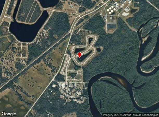
Sw County Road 769, Arcadia, FL 34269
NEARBY LISTINGS FOR SALE OR LEASE
Property Detail
Sw County Road 769
Arcadia, FL
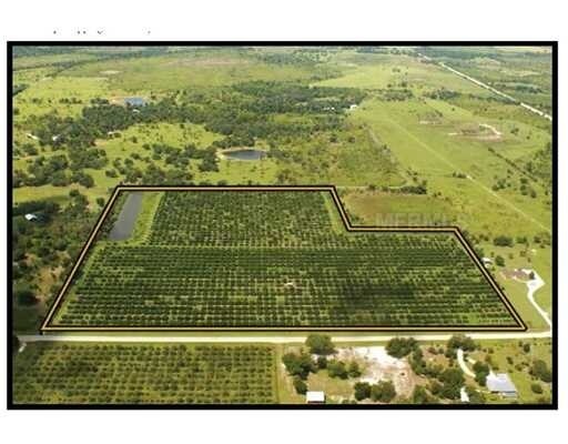
Minor Plat Sec 21-39-23 A/K/A Hollingswo
03-39-23-0000-0130-0000
FULLENKAMP MINOR PLAT UNREC PLAT 2022-0095 MPDAF: NE1/4 OF SW1/4 LESS 550 FT E & W X 440 FT N & S IN NW COR LESS RD R/W & ALSO BEG NE COR OF NE1/4 OF SW1/4 FOR POB TH N 89D06M26S W ALG N LI 787.51 FT TH S 00D33M41S W & // TO W LI 440 FT TH N 89D06M26
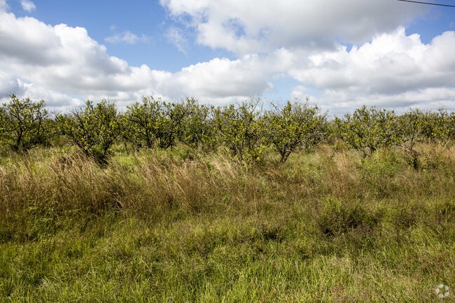
Pasture
DeSoto
A
Florida
12027C0257D
34.45 AC
0
Florida Central South Area
2024
Other Market Areas
010405
DEMOGRAPHICS near Sw County Road 769
1 Mile
3 Mile
5 Mile
2024 Total Population
91
728
3,710
2029 Population
101
789
4,033
Pop Growth 2024-2029
+ 10.99%
+ 8.38%
+ 8.71%
Average Age
49
48
51
2024 Total Households
38
293
1,571
HH Growth 2024-2029
+ 13.16%
+ 9.22%
+ 9.36%
Median Household Inc
$61,875
$48,061
$49,122
Avg Household Size
2.50
2.30
2.20
2024 Avg HH Vehicles
2.00
2.00
2.00
Median Home Value
$199,999
$157,017
$149,616
Median Year Built
1989
1989
1989
Nearby Places
Map Layers
Map Styles
 Street
 Aerial
- Restaurants
- Banks
- Shops
- Fitness
- Groceries
PUBLIC TRANSPORTATION
AIRPORT
Punta Gorda
DRIVE
WALK
Distance
Punta Gorda
24 min
14.7 mi
Freight Ports
Port Manatee
DRIVE
WALK
Distance
Port Manatee
84 min
69.2 mi
SALE & LEASE HISTORY
LISTING DATE
SALE/LEASE

Nov 27, 2017
For Sale
Nearby Properties
Address
Land Use
TOTAL SIZE
Lot Size
Zoning
Address
Land Use
TOTAL SIZE
Lot Size
Zoning
653.75 AC
A-10
Address
Land Use
TOTAL SIZE
Lot Size
Zoning
173.33 AC
P/I
Address
Land Use
TOTAL SIZE
Lot Size
Zoning
594.36 AC
A-10
Address
Land Use
TOTAL SIZE
Lot Size
Zoning
153.66 AC
P/I
Address
Land Use
TOTAL SIZE
Lot Size
Zoning
1,836 SF
17.80 AC
P/I
Address
Land Use
TOTAL SIZE
Lot Size
Zoning
8,044 SF
29.55 AC
TTRVC
Address
Land Use
TOTAL SIZE
Lot Size
Zoning
2,025 SF
28.05 AC
RVC
Address
Land Use
TOTAL SIZE
Lot Size
Zoning
9,908 SF
40 AC
RVC
Address
Land Use
TOTAL SIZE
Lot Size
Zoning
509 AC
A-5
Address
Land Use
TOTAL SIZE
Lot Size
Zoning
651.43 AC
A-10
Address
Land Use
TOTAL SIZE
Lot Size
Zoning
3,248 SF
21.20 AC
MHP
Address
Land Use
TOTAL SIZE
Lot Size
Zoning
649.60 AC
A-10
Address
Land Use
TOTAL SIZE
Lot Size
Zoning
623.08 AC
A-10
Address
Land Use
TOTAL SIZE
Lot Size
Zoning
520.65 AC
A-10
Address
Land Use
TOTAL SIZE
Lot Size
Zoning
31.61 AC
RVC
Address
Land Use
TOTAL SIZE
Lot Size
Zoning
499.70 AC
A-5
Address
Land Use
TOTAL SIZE
Lot Size
Zoning
65.31 AC
P/I
Address
Land Use
TOTAL SIZE
Lot Size
Zoning
23,142 SF
5 AC
A-5
Address
Land Use
TOTAL SIZE
Lot Size
Zoning
480 AC
A-5
Address
Land Use
TOTAL SIZE
Lot Size
Zoning
33.42 AC
PUD
Address
Land Use
TOTAL SIZE
Lot Size
Zoning
2,689 SF
398.23 AC
A-10
Address
Land Use
TOTAL SIZE
Lot Size
Zoning
227.49 AC
A-10
Address
Land Use
TOTAL SIZE
Lot Size
Zoning
351 AC
A-10
Address
Land Use
TOTAL SIZE
Lot Size
Zoning
18.83 AC
RVC
Address
Land Use
TOTAL SIZE
Lot Size
Zoning
1,537 SF
10.97 AC
RVC
Address
Land Use
TOTAL SIZE
Lot Size
Zoning
9,714 SF
10 AC
RMF-M
Address
Land Use
TOTAL SIZE
Lot Size
Zoning
10,935 SF
5 AC
CG
Address
Land Use
TOTAL SIZE
Lot Size
Zoning
21.25 AC
A-5
Address
Land Use
TOTAL SIZE
Lot Size
Zoning
4,828 SF
12.51 AC
A-10
Address
Land Use
TOTAL SIZE
Lot Size
Zoning
10,086 SF
40.88 AC
RMF-6
The World's #1 Commercial Real Estate Marketplace
Connect with us
© 2025 CoStar Group
The information above has been obtained from sources believed reliable. While we do not doubt its accuracy we have not verified it and make no guarantee, warranty or representation about it. It is your responsibility to independently confirm its accuracy and completeness. Any projections, opinions, assumptions, or estimates used are for example only and do not represent the current or future performance of the property. The value of this transaction to you depends on tax and other factors which should be evaluated by your tax, financial, and legal advisors. You and your advisors should conduct a careful, independent investigation of the property to determine to your satisfaction the suitability of the property for your needs.