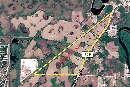
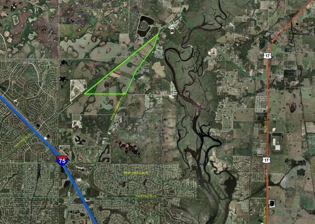
Property Record
Sw County Road 769, Arcadia, FL 34269
This Property Is For Sale
Property Detail
Sw County Road 769
21-39-23-0000-0010-0000
ALL THAT PART LYING WLY OF KINGS HWY & SELY OF WATER TRANSMISSION MAIN PARCEL AKA PIPELINE ACCESS/ROAD INST:201014010175
Pasture
DESOTO
A-10
Florida
A Areas with a 1% annual chance of flooding and a 26% chance of flooding over the life of a 30-year mortgage.
109.82 AC
2024
Florida Central South Area
2024
Other Market Areas
010405
Arcadia, FL
NEARBY LISTINGS FOR SALE OR LEASE
DEMOGRAPHICS near Sw County Road 769
1 mile
3 mile
5 mile
2025 Total Population
1,080
4,787
26,377
2030 Population
1,242
5,410
28,970
Pop Growth 2025-2030
+ 15.00%
+ 13.01%
+ 9.83%
Average Age
48
53
52
2025 Total Households
442
2,168
11,964
HH Growth 2025-2030
+ 15.38%
+ 13.42%
+ 10.04%
Median Household Inc
$58,194
$59,197
$70,266
Avg Household Size
2.40
2.10
2.20
2025 Avg HH Vehicles
2.00
2.00
2.00
Median Home Value
$346,875
$258,981
$333,512
Median Year Built
1997
1996
1998
Nearby Places
Map Layers
Map Styles
 Street
 Aerial
Transit
 Traffic
 Biking
Places
Listings with unknown addresses are not visible on the map
- Restaurants
- Banks
- Shops
- Fitness
- Groceries
PUBLIC TRANSPORTATION
AIRPORT
Punta Gorda
Drive
Walk
Distance
Punta Gorda
21 min
13.6 mi
Freight Ports
Port Manatee
Drive
Walk
Distance
Port Manatee
81 min
68.0 mi
Nearby Properties
Address
Land Use
TOTAL SIZE
Lot Size
Zoning
Address
Land Use
TOTAL SIZE
Lot Size
Zoning
653.75 AC
A-10
Address
Land Use
TOTAL SIZE
Lot Size
Zoning
41,148 SF
155.85 AC
RSF-3
Address
Land Use
TOTAL SIZE
Lot Size
Zoning
173.33 AC
P/I
Address
Land Use
TOTAL SIZE
Lot Size
Zoning
594.36 AC
A-10
Address
Land Use
TOTAL SIZE
Lot Size
Zoning
153.66 AC
P/I
Address
Land Use
TOTAL SIZE
Lot Size
Zoning
1,836 SF
17.80 AC
P/I
Address
Land Use
TOTAL SIZE
Lot Size
Zoning
8,044 SF
29.55 AC
TTRVC
Address
Land Use
TOTAL SIZE
Lot Size
Zoning
662.52 AC
EC
Address
Land Use
TOTAL SIZE
Lot Size
Zoning
9,908 SF
40 AC
RVC
Address
Land Use
TOTAL SIZE
Lot Size
Zoning
172.19 AC
PUD
Address
Land Use
TOTAL SIZE
Lot Size
Zoning
509 AC
A-5
Address
Land Use
TOTAL SIZE
Lot Size
Zoning
55,310 SF
3.20 AC
CG
Address
Land Use
TOTAL SIZE
Lot Size
Zoning
651.43 AC
A-10
Address
Land Use
TOTAL SIZE
Lot Size
Zoning
3,248 SF
21.20 AC
MHP
Address
Land Use
TOTAL SIZE
Lot Size
Zoning
649.60 AC
A-10
Address
Land Use
TOTAL SIZE
Lot Size
Zoning
623.08 AC
A-10
Address
Land Use
TOTAL SIZE
Lot Size
Zoning
520.65 AC
A-10
Address
Land Use
TOTAL SIZE
Lot Size
Zoning
30,720 SF
2.89 AC
CG
Address
Land Use
TOTAL SIZE
Lot Size
Zoning
31.61 AC
RVC
Address
Land Use
TOTAL SIZE
Lot Size
Zoning
110.53 AC
RMF-6
Address
Land Use
TOTAL SIZE
Lot Size
Zoning
499.70 AC
A-5
Address
Land Use
TOTAL SIZE
Lot Size
Zoning
65.31 AC
P/I
Address
Land Use
TOTAL SIZE
Lot Size
Zoning
501.85 AC
A-5
Address
Land Use
TOTAL SIZE
Lot Size
Zoning
23,142 SF
5 AC
A-5
Address
Land Use
TOTAL SIZE
Lot Size
Zoning
480 AC
A-5
Address
Land Use
TOTAL SIZE
Lot Size
Zoning
33.42 AC
PUD
Address
Land Use
TOTAL SIZE
Lot Size
Zoning
2,689 SF
398.23 AC
A-10
Address
Land Use
TOTAL SIZE
Lot Size
Zoning
227.49 AC
A-10
Address
Land Use
TOTAL SIZE
Lot Size
Zoning
7,732 SF
9.74 AC
A-10
Address
Land Use
TOTAL SIZE
Lot Size
Zoning
18.83 AC
RVC
The World's #1 Commercial Real Estate Marketplace
Connect with us
© 2026 CoStar Group
The information above has been obtained from sources believed reliable. While we do not doubt its accuracy we have not verified it and make no guarantee, warranty or representation about it. It is your responsibility to independently confirm its accuracy and completeness. Any projections, opinions, assumptions, or estimates used are for example only and do not represent the current or future performance of the property. The value of this transaction to you depends on tax and other factors which should be evaluated by your tax, financial, and legal advisors. You and your advisors should conduct a careful, independent investigation of the property to determine to your satisfaction the suitability of the property for your needs.