Property Record
36776 W Honeycutt Rd, Maricopa, AZ 85138

This Property Is For Sale
NEARBY LISTINGS FOR SALE OR LEASE
Property Detail
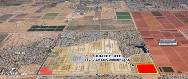
36776 W Honeycutt Rd
Phoenix-Mesa-Scottsdale, AZ
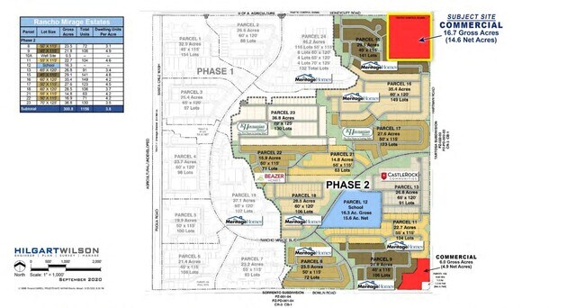
Rancho Mirage Estates Phase 2
502-03-034
PARCEL 14 OF RANCHO MIRAGE ESTATES PHASE 2 IN SEC 29-04S-04E CAB G SLD 115 638823 SQ FT 14.67 AC
Vacantlandnec
Pinal
X
Arizona
04021C0765F
14.67 AC
2024
Pinal County
2025
Phoenix
001710
DEMOGRAPHICS near 36776 W Honeycutt Rd
1 Mile
3 Mile
5 Mile
2024 Total Population
6,654
22,083
57,036
2029 Population
8,652
28,213
72,444
Pop Growth 2024-2029
+ 30.03%
+ 27.76%
+ 27.01%
Average Age
36
36
38
2024 Total Households
2,039
7,002
18,787
HH Growth 2024-2029
+ 30.06%
+ 27.76%
+ 26.90%
Median Household Inc
$78,125
$78,200
$90,430
Avg Household Size
3.20
3.10
3.00
2024 Avg HH Vehicles
2.00
2.00
2.00
Median Home Value
$287,967
$303,206
$324,615
Median Year Built
2010
2010
2007
Nearby Places
- Restaurants
- Banks
- Shops
- Fitness
- Groceries
PUBLIC TRANSPORTATION
COMMUTER RAIL
Maricopa (Sunset Limited - Amtrak, Texas Eagle - Amtrak)
DRIVE
WALK
Distance
Maricopa (Sunset Limited - Amtrak, Texas Eagle - Amtrak)
10 min
5.1 mi
AIRPORT
Phoenix Sky Harbor International
DRIVE
WALK
Distance
Phoenix Sky Harbor International
52 min
34.8 mi
Phoenix-Mesa Gateway
DRIVE
WALK
Distance
Phoenix-Mesa Gateway
59 min
39.9 mi
Freight Ports
Port of San Diego
DRIVE
WALK
Distance
Port of San Diego
375 min
345.3 mi
Nearby Properties
Address
Land Use
TOTAL SIZE
Lot Size
Zoning
Address
Land Use
TOTAL SIZE
Lot Size
Zoning
136,917 SF
1.60 AC
UNDESIGNAT
Address
Land Use
TOTAL SIZE
Lot Size
Zoning
112,719 SF
14.37 AC
UNDESIGNAT
Address
Land Use
TOTAL SIZE
Lot Size
Zoning
58,073 SF
5.74 AC
Address
Land Use
TOTAL SIZE
Lot Size
Zoning
57,070 SF
9.05 AC
Address
Land Use
TOTAL SIZE
Lot Size
Zoning
Address
Land Use
TOTAL SIZE
Lot Size
Zoning
19.14 AC
Address
Land Use
TOTAL SIZE
Lot Size
Zoning
8,537 SF
6.71 AC
Address
Land Use
TOTAL SIZE
Lot Size
Zoning
84,308 SF
2.10 AC
UNDESIGNAT
Address
Land Use
TOTAL SIZE
Lot Size
Zoning
21,995 SF
640 AC
GR
Address
Land Use
TOTAL SIZE
Lot Size
Zoning
24,516 SF
6.14 AC
Address
Land Use
TOTAL SIZE
Lot Size
Zoning
14,348 SF
1.10 AC
Address
Land Use
TOTAL SIZE
Lot Size
Zoning
16,676 SF
4.77 AC
Address
Land Use
TOTAL SIZE
Lot Size
Zoning
5.53 AC
Address
Land Use
TOTAL SIZE
Lot Size
Zoning
Address
Land Use
TOTAL SIZE
Lot Size
Zoning
8,775 SF
1.16 AC
Address
Land Use
TOTAL SIZE
Lot Size
Zoning
6,608 SF
2.34 AC
Address
Land Use
TOTAL SIZE
Lot Size
Zoning
Address
Land Use
TOTAL SIZE
Lot Size
Zoning
4,945 SF
1.80 AC
Address
Land Use
TOTAL SIZE
Lot Size
Zoning
89.60 AC
UNDESIGNAT
Address
Land Use
TOTAL SIZE
Lot Size
Zoning
Address
Land Use
TOTAL SIZE
Lot Size
Zoning
Address
Land Use
TOTAL SIZE
Lot Size
Zoning
16,236 SF
319.42 AC
UNDESIGNAT
Address
Land Use
TOTAL SIZE
Lot Size
Zoning
141.96 AC
Address
Land Use
TOTAL SIZE
Lot Size
Zoning
141.96 AC
Address
Land Use
TOTAL SIZE
Lot Size
Zoning
The World's #1 Commercial Real Estate Marketplace
Connect with us
© 2025 CoStar Group
The information above has been obtained from sources believed reliable. While we do not doubt its accuracy we have not verified it and make no guarantee, warranty or representation about it. It is your responsibility to independently confirm its accuracy and completeness. Any projections, opinions, assumptions, or estimates used are for example only and do not represent the current or future performance of the property. The value of this transaction to you depends on tax and other factors which should be evaluated by your tax, financial, and legal advisors. You and your advisors should conduct a careful, independent investigation of the property to determine to your satisfaction the suitability of the property for your needs.