Property Record
6875 Sw Highway 200, Ocala, FL 34476

NEARBY LISTINGS FOR SALE OR LEASE
Property Detail
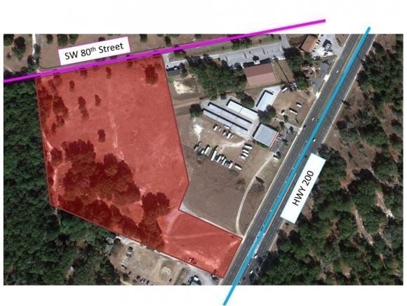
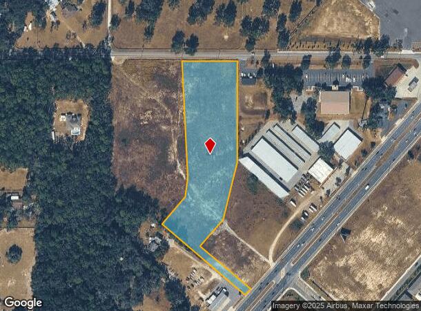
6875 Sw Highway 200
Ocala, FL
Westgate Professional Center
35637-000-03
SEC 17 TWP 16 RGE 21 PARCEL 2 COM AT NW COR OF SEC 17 TH S 00-00-04 E 25 FT TO POINT ON S ROW LINE OF SW 80TH ST(BEING A 50 FT ROW) TH N 89-53-14 E 368.62 FT TO POB TH N 89-53-14 E 275.85 FT TH S 00-06-46 E 497.24 FT TH S 13-08-09 W 293.82 FT TH S 40
Golfrange
Marion
X
Florida
12083C0701E
3
2024
5.54 AC
2024
Outlying Marion County
002505
Ocala
1,832 SF
DEMOGRAPHICS near 6875 Sw Highway 200
1 Mile
3 Mile
5 Mile
2024 Total Population
2,730
29,894
64,496
2029 Population
3,093
33,887
73,092
Pop Growth 2024-2029
+ 13.30%
+ 13.36%
+ 13.33%
Average Age
55
58
54
2024 Total Households
1,284
14,660
30,215
HH Growth 2024-2029
+ 13.32%
+ 13.29%
+ 13.23%
Median Household Inc
$51,442
$56,964
$58,477
Avg Household Size
2.10
2.00
2.10
2024 Avg HH Vehicles
2.00
1.00
2.00
Median Home Value
$182,009
$212,642
$210,112
Median Year Built
1995
1999
1997
Nearby Places
Map Layers
Map Styles
 Street
 Aerial
- Restaurants
- Banks
- Shops
- Fitness
- Groceries
SALE & LEASE HISTORY
LISTING DATE
SALE/LEASE

Sep 24, 2016
For Sale
Apr 20, 2017
For Sale
Nearby Properties
Address
Land Use
TOTAL SIZE
Lot Size
Zoning
Address
Land Use
TOTAL SIZE
Lot Size
Zoning
189,662 SF
25.54 AC
B2
Address
Land Use
TOTAL SIZE
Lot Size
Zoning
37,448 SF
35.67 AC
PD
Address
Land Use
TOTAL SIZE
Lot Size
Zoning
155,077 SF
40.05 AC
PUD
Address
Land Use
TOTAL SIZE
Lot Size
Zoning
41,233 SF
23.19 AC
R3
Address
Land Use
TOTAL SIZE
Lot Size
Zoning
124,557 SF
39.04 AC
GU
Address
Land Use
TOTAL SIZE
Lot Size
Zoning
59,706 SF
10.01 AC
PD
Address
Land Use
TOTAL SIZE
Lot Size
Zoning
96,094 SF
13.66 AC
B2
Address
Land Use
TOTAL SIZE
Lot Size
Zoning
62,253 SF
6.52 AC
PUD
Address
Land Use
TOTAL SIZE
Lot Size
Zoning
95,496 SF
25.25 AC
R3
Address
Land Use
TOTAL SIZE
Lot Size
Zoning
74,928 SF
7.80 AC
PUD
Address
Land Use
TOTAL SIZE
Lot Size
Zoning
18,035 SF
3.33 AC
B2
Address
Land Use
TOTAL SIZE
Lot Size
Zoning
55,985 SF
21.78 AC
B4
Address
Land Use
TOTAL SIZE
Lot Size
Zoning
139,728 SF
22.86 AC
B4
Address
Land Use
TOTAL SIZE
Lot Size
Zoning
84,004 SF
9.77 AC
SC
Address
Land Use
TOTAL SIZE
Lot Size
Zoning
65,060 SF
11.90 AC
B2
Address
Land Use
TOTAL SIZE
Lot Size
Zoning
98,205 SF
13.41 AC
B2
Address
Land Use
TOTAL SIZE
Lot Size
Zoning
42,673 SF
13.72 AC
A1
Address
Land Use
TOTAL SIZE
Lot Size
Zoning
42,159 SF
5.95 AC
B2
Address
Land Use
TOTAL SIZE
Lot Size
Zoning
48,518 SF
84.49 AC
A1
Address
Land Use
TOTAL SIZE
Lot Size
Zoning
20,982 SF
4 AC
O1
Address
Land Use
TOTAL SIZE
Lot Size
Zoning
47,600 SF
735.53 AC
PD
Address
Land Use
TOTAL SIZE
Lot Size
Zoning
99,045 SF
7.19 AC
B2
Address
Land Use
TOTAL SIZE
Lot Size
Zoning
82,465 SF
6.13 AC
B2
Address
Land Use
TOTAL SIZE
Lot Size
Zoning
286.80 AC
PUD
Address
Land Use
TOTAL SIZE
Lot Size
Zoning
58,381 SF
5.12 AC
R3
Address
Land Use
TOTAL SIZE
Lot Size
Zoning
27,882 SF
9.95 AC
INST
Address
Land Use
TOTAL SIZE
Lot Size
Zoning
13,943 SF
0.43 AC
B2
Address
Land Use
TOTAL SIZE
Lot Size
Zoning
25,128 SF
4.38 AC
PD
Address
Land Use
TOTAL SIZE
Lot Size
Zoning
16,214 SF
4.91 AC
B2
The World's #1 Commercial Real Estate Marketplace
Connect with us
© 2025 CoStar Group
The information above has been obtained from sources believed reliable. While we do not doubt its accuracy we have not verified it and make no guarantee, warranty or representation about it. It is your responsibility to independently confirm its accuracy and completeness. Any projections, opinions, assumptions, or estimates used are for example only and do not represent the current or future performance of the property. The value of this transaction to you depends on tax and other factors which should be evaluated by your tax, financial, and legal advisors. You and your advisors should conduct a careful, independent investigation of the property to determine to your satisfaction the suitability of the property for your needs.