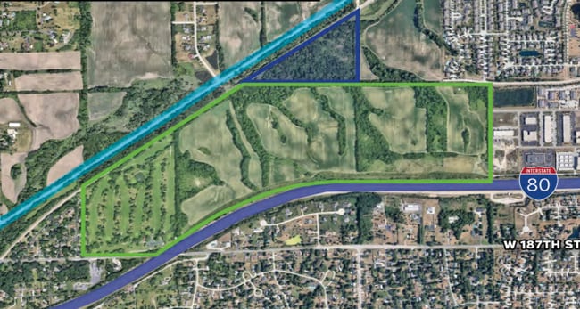
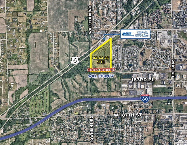
Property Record
W 183Rd St, Mokena, IL 60448
This Property Is For Sale
NEARBY LISTINGS FOR SALE OR LEASE
Property Detail
W 183Rd St
19-09-06-100-011
THAT PRT OF THE W1/2 OF THE NW1/4 (EX THE W 2 ACRES THROF) THE W1/2 OF THE E1/2 OF THE NW1/4 OF SEC. 6, T35N-R12E, LYG N OF
Agriculturalland
Will
X
Illinois
17197C0195G
65.99 AC
2024
Joliet/Central Will
2024
Chicago
883519
Chicago-Naperville-Elgin, IL-IN-WI
DEMOGRAPHICS near W 183Rd St
1 Mile
3 Mile
5 Mile
2024 Total Population
4,229
36,972
123,159
2029 Population
4,128
36,463
121,621
Pop Growth 2024-2029
(2.39%)
(1.38%)
(1.25%)
Average Age
45
44
42
2024 Total Households
1,553
13,482
43,666
HH Growth 2024-2029
(2.77%)
(1.54%)
(1.42%)
Median Household Inc
$91,394
$107,317
$111,205
Avg Household Size
2.70
2.70
2.80
2024 Avg HH Vehicles
2.00
2.00
2.00
Median Home Value
$352,283
$364,062
$343,666
Median Year Built
1992
1994
1993
Nearby Places
- Restaurants
- Banks
- Shops
- Fitness
- Groceries
PUBLIC TRANSPORTATION
COMMUTER RAIL
Orland Park - 179Th Street Station (SouthWest Service - Northeast Illinois Regional Commuter Railroad (Metra))
DRIVE
WALK
Distance
Orland Park - 179Th Street Station (SouthWest Service - Northeast Illinois Regional Commuter Railroad (Metra))
12 min
8.4 mi
AIRPORT
Chicago Midway International
DRIVE
WALK
Distance
Chicago Midway International
40 min
31.9 mi
Chicago O'Hare International
DRIVE
WALK
Distance
Chicago O'Hare International
57 min
43.3 mi
Freight Ports
Port Milwaukee
DRIVE
WALK
Distance
Port Milwaukee
138 min
115.1 mi
Nearby Properties
Address
Land Use
TOTAL SIZE
Lot Size
Zoning
Address
Land Use
TOTAL SIZE
Lot Size
Zoning
68,954 SF
Address
Land Use
TOTAL SIZE
Lot Size
Zoning
79,455 SF
5.36 AC
Address
Land Use
TOTAL SIZE
Lot Size
Zoning
253,215 SF
29.36 AC
Address
Land Use
TOTAL SIZE
Lot Size
Zoning
77,290 SF
10.23 AC
Address
Land Use
TOTAL SIZE
Lot Size
Zoning
77,779 SF
1.65 AC
Address
Land Use
TOTAL SIZE
Lot Size
Zoning
8,826 SF
61.49 AC
Address
Land Use
TOTAL SIZE
Lot Size
Zoning
63,239 SF
9.25 AC
Address
Land Use
TOTAL SIZE
Lot Size
Zoning
53,072 SF
0.63 AC
Address
Land Use
TOTAL SIZE
Lot Size
Zoning
143,821 SF
4.80 AC
Address
Land Use
TOTAL SIZE
Lot Size
Zoning
46,151 SF
4.40 AC
Address
Land Use
TOTAL SIZE
Lot Size
Zoning
2.06 AC
Address
Land Use
TOTAL SIZE
Lot Size
Zoning
57,499 SF
7.17 AC
Address
Land Use
TOTAL SIZE
Lot Size
Zoning
53,385 SF
1.53 AC
Address
Land Use
TOTAL SIZE
Lot Size
Zoning
2.90 AC
Address
Land Use
TOTAL SIZE
Lot Size
Zoning
935 SF
21.49 AC
Address
Land Use
TOTAL SIZE
Lot Size
Zoning
3.70 AC
Address
Land Use
TOTAL SIZE
Lot Size
Zoning
29,610 SF
4.46 AC
Address
Land Use
TOTAL SIZE
Lot Size
Zoning
31,680 SF
3.47 AC
Address
Land Use
TOTAL SIZE
Lot Size
Zoning
33,859 SF
6.79 AC
Address
Land Use
TOTAL SIZE
Lot Size
Zoning
29,304 SF
1.94 AC
Address
Land Use
TOTAL SIZE
Lot Size
Zoning
30,640 SF
5.23 AC
Address
Land Use
TOTAL SIZE
Lot Size
Zoning
63,372 SF
4.38 AC
Address
Land Use
TOTAL SIZE
Lot Size
Zoning
1,296 SF
9.16 AC
Address
Land Use
TOTAL SIZE
Lot Size
Zoning
111,100 SF
8.87 AC
Address
Land Use
TOTAL SIZE
Lot Size
Zoning
2,268 SF
38.41 AC
Address
Land Use
TOTAL SIZE
Lot Size
Zoning
14.17 AC
Address
Land Use
TOTAL SIZE
Lot Size
Zoning
3.96 AC
Address
Land Use
TOTAL SIZE
Lot Size
Zoning
44,484 SF
3.13 AC
Address
Land Use
TOTAL SIZE
Lot Size
Zoning
20,679 SF
2.60 AC
Address
Land Use
TOTAL SIZE
Lot Size
Zoning
36,471 SF
2.28 AC
The World's #1 Commercial Real Estate Marketplace
Connect with us
© 2025 CoStar Group
The information above has been obtained from sources believed reliable. While we do not doubt its accuracy we have not verified it and make no guarantee, warranty or representation about it. It is your responsibility to independently confirm its accuracy and completeness. Any projections, opinions, assumptions, or estimates used are for example only and do not represent the current or future performance of the property. The value of this transaction to you depends on tax and other factors which should be evaluated by your tax, financial, and legal advisors. You and your advisors should conduct a careful, independent investigation of the property to determine to your satisfaction the suitability of the property for your needs.