Property Record
Sw Loop 410, San Antonio, TX 78227

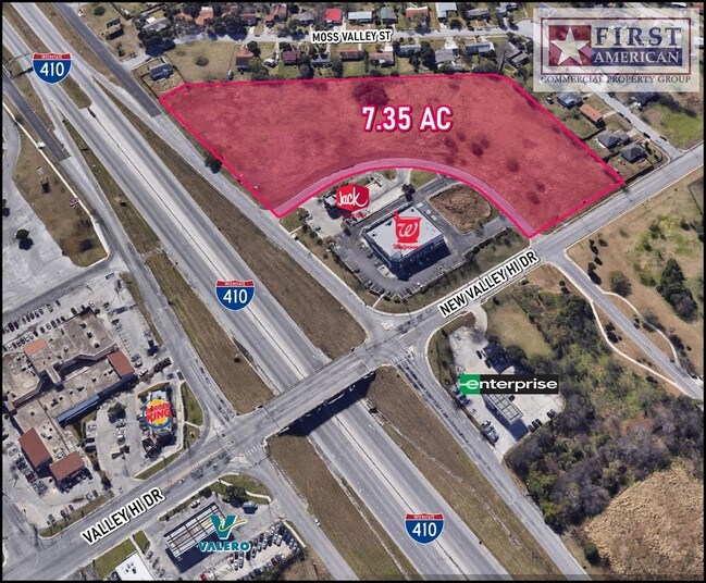
Property Detail
Sw Loop 410
San Antonio-New Braunfels, TX
NCB 15149 (MKS TERRITORIES) BLK 49 LO T 26 2023- NEW PER PLAT 20002/2213 FILED 9-2-2022. CR-56878. JLF/GIS/6-27-2023
15149-049-0260
BEXAR
Officebuilding
Texas
2024
23
2025
1.20 AC
171802
South
1,440 SF
San Antonio
NEARBY LISTINGS FOR SALE OR LEASE
DEMOGRAPHICS near Sw Loop 410
1 mile
3 mile
5 mile
2025 Total Population
24,116
91,878
206,868
2030 Population
26,802
98,503
219,862
Pop Growth 2025-2030
+ 11.14%
+ 7.21%
+ 6.28%
Average Age
29
33
34
2025 Total Households
5,687
26,432
62,729
HH Growth 2025-2030
+ 13.06%
+ 7.46%
+ 6.45%
Median Household Inc
$62,024
$55,563
$60,765
Avg Household Size
3.20
3.10
3.10
2025 Avg HH Vehicles
2.00
2.00
2.00
Median Home Value
$187,549
$180,432
$206,239
Median Year Built
2001
1986
1993
Nearby Places
Map Layers
Map Styles
 Street
 Aerial
Layers
 Traffic
 Biking
Places
Listings with unknown addresses are not visible on the map
- Restaurants
- Banks
- Shops
- Fitness
- Groceries
PUBLIC TRANSPORTATION
AIRPORT
San Antonio International
Drive
Walk
Distance
San Antonio International
23 min
17.2 mi
SALE & LEASE HISTORY
LISTING DATE
SALE/LEASE

Sep 24, 2016
For Sale
Oct 10, 2017
For Sale
Aug 23, 2017
For Sale
Nearby Properties
Address
Land Use
TOTAL SIZE
Lot Size
Zoning
Address
Land Use
TOTAL SIZE
Lot Size
Zoning
369,951 SF
21.42 AC
Address
Land Use
TOTAL SIZE
Lot Size
Zoning
505,914 SF
41.01 AC
Address
Land Use
TOTAL SIZE
Lot Size
Zoning
331,055 SF
15.98 AC
Address
Land Use
TOTAL SIZE
Lot Size
Zoning
286,881 SF
37.13 AC
Address
Land Use
TOTAL SIZE
Lot Size
Zoning
288,476 SF
9.87 AC
Address
Land Use
TOTAL SIZE
Lot Size
Zoning
248,405 SF
14.04 AC
Address
Land Use
TOTAL SIZE
Lot Size
Zoning
240,775 SF
13.63 AC
Address
Land Use
TOTAL SIZE
Lot Size
Zoning
247.88 AC
Address
Land Use
TOTAL SIZE
Lot Size
Zoning
2,457 SF
60.19 AC
Address
Land Use
TOTAL SIZE
Lot Size
Zoning
168,273 SF
23.13 AC
Address
Land Use
TOTAL SIZE
Lot Size
Zoning
149,184 SF
7.42 AC
Address
Land Use
TOTAL SIZE
Lot Size
Zoning
229,416 SF
12 AC
Address
Land Use
TOTAL SIZE
Lot Size
Zoning
186,797 SF
23.22 AC
Address
Land Use
TOTAL SIZE
Lot Size
Zoning
73,567 SF
18 AC
Address
Land Use
TOTAL SIZE
Lot Size
Zoning
223,403 SF
15.98 AC
Address
Land Use
TOTAL SIZE
Lot Size
Zoning
235,873 SF
12.50 AC
Address
Land Use
TOTAL SIZE
Lot Size
Zoning
180,644 SF
15.85 AC
Address
Land Use
TOTAL SIZE
Lot Size
Zoning
128,200 SF
10.66 AC
Address
Land Use
TOTAL SIZE
Lot Size
Zoning
247,258 SF
12.54 AC
Address
Land Use
TOTAL SIZE
Lot Size
Zoning
107,135 SF
6.62 AC
Address
Land Use
TOTAL SIZE
Lot Size
Zoning
109,420 SF
215.95 AC
Address
Land Use
TOTAL SIZE
Lot Size
Zoning
1,394 SF
72.83 AC
Address
Land Use
TOTAL SIZE
Lot Size
Zoning
131,991 SF
7.86 AC
Address
Land Use
TOTAL SIZE
Lot Size
Zoning
216,680 SF
21.92 AC
Address
Land Use
TOTAL SIZE
Lot Size
Zoning
87,790 SF
7.48 AC
Address
Land Use
TOTAL SIZE
Lot Size
Zoning
36.29 AC
Address
Land Use
TOTAL SIZE
Lot Size
Zoning
76,299 SF
7.29 AC
Address
Land Use
TOTAL SIZE
Lot Size
Zoning
38,002 SF
565.81 AC
Address
Land Use
TOTAL SIZE
Lot Size
Zoning
40,441 SF
17.01 AC
Address
Land Use
TOTAL SIZE
Lot Size
Zoning
274.73 AC
The World's #1 Commercial Real Estate Marketplace
Connect with us
© 2026 CoStar Group
The information above has been obtained from sources believed reliable. While we do not doubt its accuracy we have not verified it and make no guarantee, warranty or representation about it. It is your responsibility to independently confirm its accuracy and completeness. Any projections, opinions, assumptions, or estimates used are for example only and do not represent the current or future performance of the property. The value of this transaction to you depends on tax and other factors which should be evaluated by your tax, financial, and legal advisors. You and your advisors should conduct a careful, independent investigation of the property to determine to your satisfaction the suitability of the property for your needs.