Property Record
1470 N 43Rd Ave, Phoenix, AZ 85009
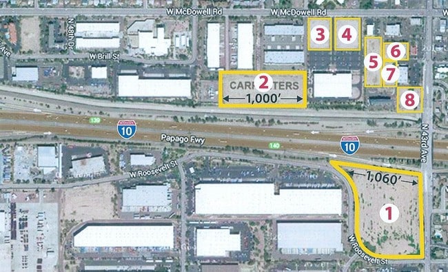
NEARBY LISTINGS FOR SALE OR LEASE
Property Detail
1470 N 43Rd Ave
Phoenix-Mesa-Chandler, AZ
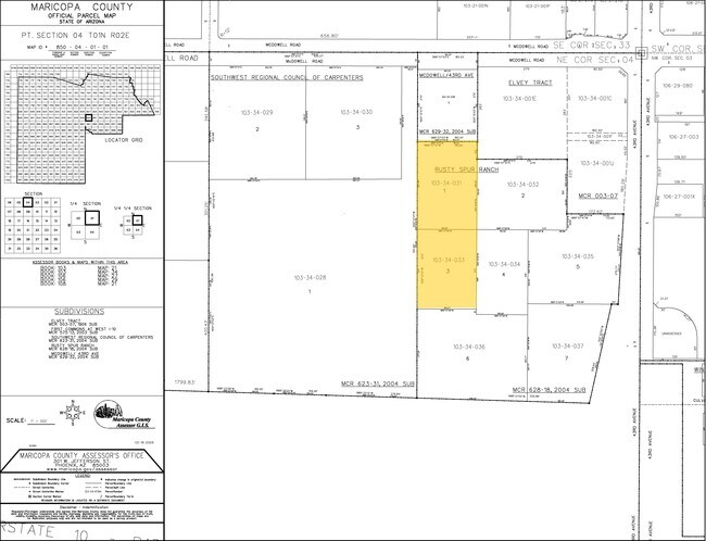
Rusty Spur Ranch
103-34-033
RUSTY SPUR RANCH MCR 628-18
Commercialacreage
Maricopa
X
Arizona
04013C2185L
3
2025
1.01 AC
2025
Northwest Phoenix
112507
Phoenix
DEMOGRAPHICS near 1470 N 43Rd Ave
1 Mile
3 Mile
5 Mile
2024 Total Population
21,868
131,236
403,003
2029 Population
23,360
140,823
434,272
Pop Growth 2024-2029
+ 6.82%
+ 7.31%
+ 7.76%
Average Age
34
33
33
2024 Total Households
6,611
36,488
125,581
HH Growth 2024-2029
+ 6.96%
+ 7.49%
+ 8.27%
Median Household Inc
$40,038
$48,024
$49,571
Avg Household Size
3.10
3.40
3.00
2024 Avg HH Vehicles
2.00
2.00
2.00
Median Home Value
$191,893
$191,965
$238,231
Median Year Built
1973
1971
1973
Nearby Places
Map Layers
Map Styles
 Street
 Aerial
- Restaurants
- Banks
- Shops
- Fitness
- Groceries
PUBLIC TRANSPORTATION
AIRPORT
Phoenix Sky Harbor International
DRIVE
WALK
Distance
Phoenix Sky Harbor International
17 min
10.9 mi
Phoenix-Mesa Gateway
DRIVE
WALK
Distance
Phoenix-Mesa Gateway
50 min
38.1 mi
SALE & LEASE HISTORY
LISTING DATE
SALE/LEASE

Sep 24, 2016
For Sale
Nearby Properties
Address
Land Use
TOTAL SIZE
Lot Size
Zoning
Address
Land Use
TOTAL SIZE
Lot Size
Zoning
569,517 SF
33.38 AC
PUD
Address
Land Use
TOTAL SIZE
Lot Size
Zoning
270,000 SF
12.90 AC
I-1
Address
Land Use
TOTAL SIZE
Lot Size
Zoning
1,378,775 SF
86.09 AC
M-H
Address
Land Use
TOTAL SIZE
Lot Size
Zoning
91,000 SF
7.57 AC
I-1
Address
Land Use
TOTAL SIZE
Lot Size
Zoning
86,350 SF
25.82 AC
I-1
Address
Land Use
TOTAL SIZE
Lot Size
Zoning
69,542 SF
4.92 AC
I-P
Address
Land Use
TOTAL SIZE
Lot Size
Zoning
377,037 SF
35.46 AC
R1-6
Address
Land Use
TOTAL SIZE
Lot Size
Zoning
1,205,743 SF
59.34 AC
I-1
Address
Land Use
TOTAL SIZE
Lot Size
Zoning
1,063,188 SF
59.94 AC
Address
Land Use
TOTAL SIZE
Lot Size
Zoning
4,900 SF
12.05 AC
R1-6
Address
Land Use
TOTAL SIZE
Lot Size
Zoning
42,631 SF
2.90 AC
A-2
Address
Land Use
TOTAL SIZE
Lot Size
Zoning
281,038 SF
7.71 AC
Address
Land Use
TOTAL SIZE
Lot Size
Zoning
32,600 SF
2.38 AC
R-5
Address
Land Use
TOTAL SIZE
Lot Size
Zoning
659,834 SF
42.04 AC
R-6
Address
Land Use
TOTAL SIZE
Lot Size
Zoning
449,802 SF
27.08 AC
A-1
Address
Land Use
TOTAL SIZE
Lot Size
Zoning
436,817 SF
23.21 AC
I-P
Address
Land Use
TOTAL SIZE
Lot Size
Zoning
316,386 SF
45.04 AC
R16
Address
Land Use
TOTAL SIZE
Lot Size
Zoning
592,330 SF
36.89 AC
I-2
Address
Land Use
TOTAL SIZE
Lot Size
Zoning
350,874 SF
28.66 AC
C-C
Address
Land Use
TOTAL SIZE
Lot Size
Zoning
554,011 SF
26.10 AC
I-P
Address
Land Use
TOTAL SIZE
Lot Size
Zoning
489,284 SF
28.64 AC
I-1
Address
Land Use
TOTAL SIZE
Lot Size
Zoning
662,796 SF
42.11 AC
I-1
Address
Land Use
TOTAL SIZE
Lot Size
Zoning
532,713 SF
27.31 AC
Address
Land Use
TOTAL SIZE
Lot Size
Zoning
347,565 SF
21.44 AC
A1
Address
Land Use
TOTAL SIZE
Lot Size
Zoning
603,910 SF
30.70 AC
I-1
Address
Land Use
TOTAL SIZE
Lot Size
Zoning
874,407 SF
38.57 AC
I-P
Address
Land Use
TOTAL SIZE
Lot Size
Zoning
18,522 SF
1.69 AC
R-6
Address
Land Use
TOTAL SIZE
Lot Size
Zoning
503,510 SF
27.80 AC
I-1
Address
Land Use
TOTAL SIZE
Lot Size
Zoning
208,563 SF
9.78 AC
R-6
Address
Land Use
TOTAL SIZE
Lot Size
Zoning
454,368 SF
23.36 AC
I-1
The World's #1 Commercial Real Estate Marketplace
Connect with us
© 2026 CoStar Group
The information above has been obtained from sources believed reliable. While we do not doubt its accuracy we have not verified it and make no guarantee, warranty or representation about it. It is your responsibility to independently confirm its accuracy and completeness. Any projections, opinions, assumptions, or estimates used are for example only and do not represent the current or future performance of the property. The value of this transaction to you depends on tax and other factors which should be evaluated by your tax, financial, and legal advisors. You and your advisors should conduct a careful, independent investigation of the property to determine to your satisfaction the suitability of the property for your needs.