Property Record
Sw Sunnybreeze Rd, Arcadia, FL 34269
NEARBY LISTINGS FOR SALE OR LEASE
Property Detail
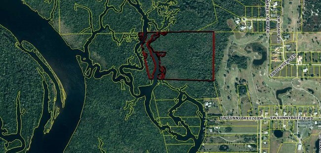
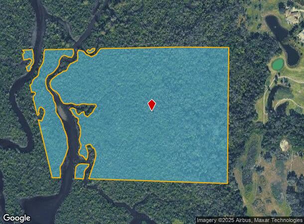
Sw Sunnybreeze Rd
Arcadia, FL
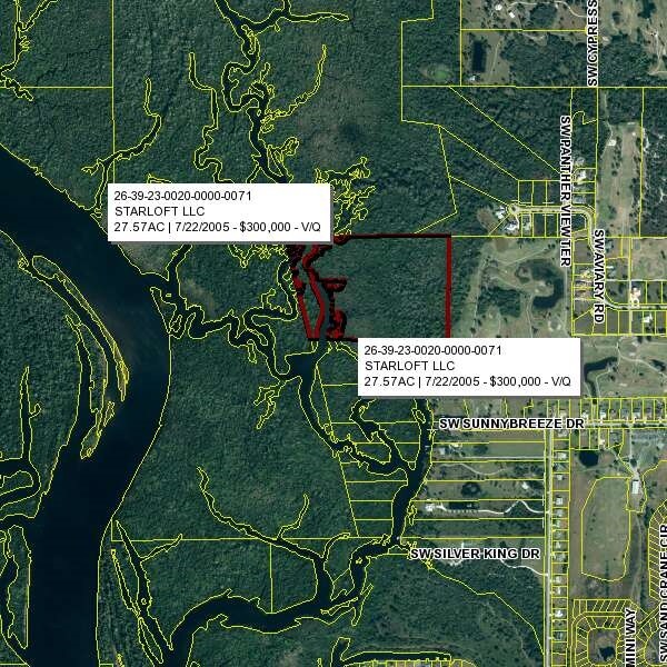
Allard Acres
26-39-23-0020-0000-0071
ALLARD ACRES THAT PART OF LOT 7 & 7B DESC AS: BEG AT PERMANENT REFERENCE MONUMENT # 3547 MARKING THE NE COR OF SAID LOT 7 TH S 00D30M00S W ALG E LI 948.25 FT TO A PERMANENT REF MONUMENT # 3547 TH N 88D07M50S W 1182.24 FT TO W LI TH N 12D 54M25S W 940
Miscellaneous
DeSoto
AE
Florida
12015C0086G
7
2024
27.57 AC
2024
Florida Central South Area
010405
Other Market Areas
DEMOGRAPHICS near Sw Sunnybreeze Rd
1 Mile
3 Mile
5 Mile
2024 Total Population
682
6,660
25,069
2029 Population
722
7,639
29,602
Pop Growth 2024-2029
+ 5.87%
+ 14.70%
+ 18.08%
Average Age
56
51
52
2024 Total Households
317
2,836
11,486
HH Growth 2024-2029
+ 6.31%
+ 14.99%
+ 18.49%
Median Household Inc
$47,818
$56,104
$57,278
Avg Household Size
1.90
2.30
2.10
2024 Avg HH Vehicles
1.00
2.00
2.00
Median Home Value
$113,158
$241,780
$248,168
Median Year Built
1990
1992
1994
Nearby Places
Map Layers
Map Styles
 Street
 Aerial
- Restaurants
- Banks
- Shops
- Fitness
- Groceries
PUBLIC TRANSPORTATION
AIRPORT
Punta Gorda
DRIVE
WALK
Distance
Punta Gorda
25 min
13.7 mi
Freight Ports
Port Manatee
DRIVE
WALK
Distance
Port Manatee
101 min
75.9 mi
SALE & LEASE HISTORY
LISTING DATE
SALE/LEASE

Jul 21, 2017
For Sale
Nearby Properties
Address
Land Use
TOTAL SIZE
Lot Size
Zoning
Address
Land Use
TOTAL SIZE
Lot Size
Zoning
1,225,024 SF
170.84 AC
IL
Address
Land Use
TOTAL SIZE
Lot Size
Zoning
2,148 SF
121.95 AC
PD
Address
Land Use
TOTAL SIZE
Lot Size
Zoning
15,866 SF
63.03 AC
TTRVC
Address
Land Use
TOTAL SIZE
Lot Size
Zoning
1,836 SF
17.80 AC
P/I
Address
Land Use
TOTAL SIZE
Lot Size
Zoning
8,044 SF
29.55 AC
TTRVC
Address
Land Use
TOTAL SIZE
Lot Size
Zoning
2,025 SF
28.05 AC
RVC
Address
Land Use
TOTAL SIZE
Lot Size
Zoning
9,908 SF
40 AC
RVC
Address
Land Use
TOTAL SIZE
Lot Size
Zoning
172.19 AC
PUD
Address
Land Use
TOTAL SIZE
Lot Size
Zoning
509 AC
A-5
Address
Land Use
TOTAL SIZE
Lot Size
Zoning
3,248 SF
21.20 AC
MHP
Address
Land Use
TOTAL SIZE
Lot Size
Zoning
27,214 SF
7.92 AC
A-5
Address
Land Use
TOTAL SIZE
Lot Size
Zoning
432 SF
20 AC
A-5
Address
Land Use
TOTAL SIZE
Lot Size
Zoning
4,800 SF
40.53 AC
PUD
Address
Land Use
TOTAL SIZE
Lot Size
Zoning
31.61 AC
RVC
Address
Land Use
TOTAL SIZE
Lot Size
Zoning
499.70 AC
A-5
Address
Land Use
TOTAL SIZE
Lot Size
Zoning
65.31 AC
P/I
Address
Land Use
TOTAL SIZE
Lot Size
Zoning
501.85 AC
A-5
Address
Land Use
TOTAL SIZE
Lot Size
Zoning
23,142 SF
5 AC
A-5
Address
Land Use
TOTAL SIZE
Lot Size
Zoning
480 AC
A-5
Address
Land Use
TOTAL SIZE
Lot Size
Zoning
33.42 AC
PUD
Address
Land Use
TOTAL SIZE
Lot Size
Zoning
2,689 SF
398.23 AC
A-10
Address
Land Use
TOTAL SIZE
Lot Size
Zoning
8,838 SF
2.43 AC
RMF-6
Address
Land Use
TOTAL SIZE
Lot Size
Zoning
227.49 AC
A-10
Address
Land Use
TOTAL SIZE
Lot Size
Zoning
18.83 AC
RVC
Address
Land Use
TOTAL SIZE
Lot Size
Zoning
1,537 SF
10.97 AC
RVC
Address
Land Use
TOTAL SIZE
Lot Size
Zoning
9,714 SF
10 AC
RMF-M
Address
Land Use
TOTAL SIZE
Lot Size
Zoning
10,935 SF
5 AC
CG
Address
Land Use
TOTAL SIZE
Lot Size
Zoning
21.25 AC
A-5
Address
Land Use
TOTAL SIZE
Lot Size
Zoning
10,086 SF
40.88 AC
RMF-6
Address
Land Use
TOTAL SIZE
Lot Size
Zoning
7,050 SF
4.49 AC
RSF-3
The World's #1 Commercial Real Estate Marketplace
Connect with us
© 2025 CoStar Group
The information above has been obtained from sources believed reliable. While we do not doubt its accuracy we have not verified it and make no guarantee, warranty or representation about it. It is your responsibility to independently confirm its accuracy and completeness. Any projections, opinions, assumptions, or estimates used are for example only and do not represent the current or future performance of the property. The value of this transaction to you depends on tax and other factors which should be evaluated by your tax, financial, and legal advisors. You and your advisors should conduct a careful, independent investigation of the property to determine to your satisfaction the suitability of the property for your needs.