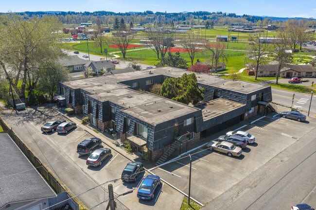
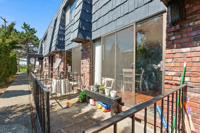
Property Record
Sw William Ave, Chehalis, WA 98532

Property Detail
Sw William Ave
Centralia, WA
SECTION 32 TOWNSHIP 14N RANGE 02W LT 1-3 & 14 BLK 1 HENDERSON LAND CO 2ND ADD
005604-065-001
LEWIS
Multifamilydwelling
Washington
CO
1-3,1
2024
0.52 AC
2025
Washington State Area
971000
Other Market Areas
11,054 SF
NEARBY LISTINGS FOR SALE OR LEASE
-
-
View all Chehalis listings for sale on LoopNet.com
DEMOGRAPHICS near Sw William Ave
1 mile
3 mile
5 mile
2025 Total Population
5,607
11,638
29,234
2030 Population
5,796
12,096
30,316
Pop Growth 2025-2030
+ 3.37%
+ 3.94%
+ 3.70%
Average Age
38
39
40
2025 Total Households
2,100
4,455
11,122
HH Growth 2025-2030
+ 3.33%
+ 3.93%
+ 3.68%
Median Household Inc
$74,480
$77,768
$75,144
Avg Household Size
2.50
2.50
2.50
2025 Avg HH Vehicles
2.00
2.00
2.00
Median Home Value
$357,749
$383,625
$398,874
Median Year Built
1966
1974
1977
Nearby Places
Map Layers
Map Styles
 Street
 Aerial
Layers
 Traffic
 Biking
Places
Listings with unknown addresses are not visible on the map
- Restaurants
- Banks
- Shops
- Fitness
- Groceries
PUBLIC TRANSPORTATION
COMMUTER RAIL
Drive
Walk
Distance
12 min
5.5 mi
SALE & LEASE HISTORY
LISTING DATE
SALE/LEASE

May 04, 2021
For Sale
Nearby Properties
Address
Land Use
TOTAL SIZE
Lot Size
Zoning
Address
Land Use
TOTAL SIZE
Lot Size
Zoning
323,610 SF
47.34 AC
IL
Address
Land Use
TOTAL SIZE
Lot Size
Zoning
83,945 SF
3.12 AC
ILCG
Address
Land Use
TOTAL SIZE
Lot Size
Zoning
215,594 SF
42.22 AC
RUGA
Address
Land Use
TOTAL SIZE
Lot Size
Zoning
147,432 SF
8.28 AC
IL
Address
Land Use
TOTAL SIZE
Lot Size
Zoning
739,659 SF
37.76 AC
IL
Address
Land Use
TOTAL SIZE
Lot Size
Zoning
15,000 SF
66.30 AC
EPFI
Address
Land Use
TOTAL SIZE
Lot Size
Zoning
62,057 SF
2.08 AC
EPFG
Address
Land Use
TOTAL SIZE
Lot Size
Zoning
1,714 SF
220.30 AC
EPFA
Address
Land Use
TOTAL SIZE
Lot Size
Zoning
222,077 SF
Address
Land Use
TOTAL SIZE
Lot Size
Zoning
3,012 SF
11.23 AC
R4
Address
Land Use
TOTAL SIZE
Lot Size
Zoning
82,667 SF
Address
Land Use
TOTAL SIZE
Lot Size
Zoning
43,477 SF
8.64 AC
CG
Address
Land Use
TOTAL SIZE
Lot Size
Zoning
53,794 SF
7.50 AC
EPFS
Address
Land Use
TOTAL SIZE
Lot Size
Zoning
172,800 SF
13.97 AC
IL
Address
Land Use
TOTAL SIZE
Lot Size
Zoning
118,034 SF
5.90 AC
IL
Address
Land Use
TOTAL SIZE
Lot Size
Zoning
3,742 SF
21.83 AC
EPFU
Address
Land Use
TOTAL SIZE
Lot Size
Zoning
34,150 SF
7.20 AC
CG
Address
Land Use
TOTAL SIZE
Lot Size
Zoning
2,741 SF
20.47 AC
EPFS
Address
Land Use
TOTAL SIZE
Lot Size
Zoning
70,940 SF
10.34 AC
IL
Address
Land Use
TOTAL SIZE
Lot Size
Zoning
4,361 SF
5.41 AC
R2
Address
Land Use
TOTAL SIZE
Lot Size
Zoning
94,044 SF
Address
Land Use
TOTAL SIZE
Lot Size
Zoning
2,750 SF
2 AC
CG
Address
Land Use
TOTAL SIZE
Lot Size
Zoning
13.11 AC
Address
Land Use
TOTAL SIZE
Lot Size
Zoning
83,043 SF
6.76 AC
CG
Address
Land Use
TOTAL SIZE
Lot Size
Zoning
62,352 SF
17.32 AC
IL
Address
Land Use
TOTAL SIZE
Lot Size
Zoning
30,308 SF
45.31 AC
OSPF
Address
Land Use
TOTAL SIZE
Lot Size
Zoning
4.47 AC
CG
Address
Land Use
TOTAL SIZE
Lot Size
Zoning
93,000 SF
6.54 AC
IL
Address
Land Use
TOTAL SIZE
Lot Size
Zoning
31,418 SF
1.75 AC
CF
Address
Land Use
TOTAL SIZE
Lot Size
Zoning
4.32 AC
RUGA
The World's #1 Commercial Real Estate Marketplace
Connect with us
© 2026 CoStar Group
The information above has been obtained from sources believed reliable. While we do not doubt its accuracy we have not verified it and make no guarantee, warranty or representation about it. It is your responsibility to independently confirm its accuracy and completeness. Any projections, opinions, assumptions, or estimates used are for example only and do not represent the current or future performance of the property. The value of this transaction to you depends on tax and other factors which should be evaluated by your tax, financial, and legal advisors. You and your advisors should conduct a careful, independent investigation of the property to determine to your satisfaction the suitability of the property for your needs.