Property Record
Swamp Circle Rd, Deale, MD 20751
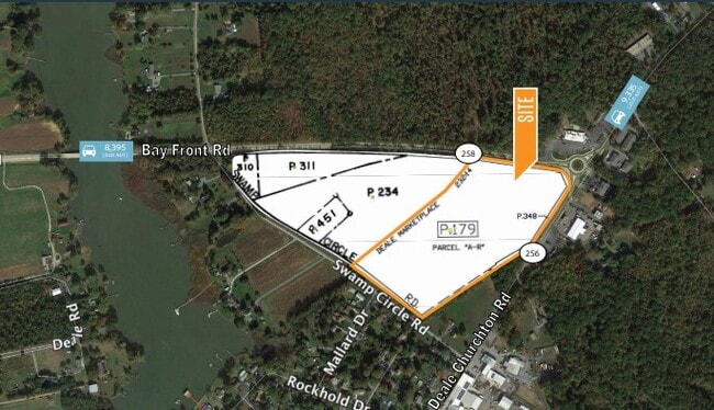

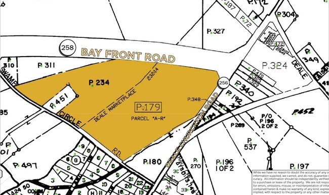
This Property Is For Sale
Property Detail
Swamp Circle Rd
07-000-03588199
PARCEL A-R OR 15.77A SWAMP CIRCLE RD DEALE MARKETPLACE
Commercialacreage
ANNE ARUNDEL
C1
Maryland
B and X Area of moderate flood hazard, usually the area between the limits of the 100-year and 500-year floods.
15.77 AC
2024
Southern Anne Arundel
2025
Baltimore
707002
Baltimore-Columbia-Towson, MD
NEARBY LISTINGS FOR SALE OR LEASE
-
-
View all Deale listings for sale on LoopNet.com
DEMOGRAPHICS near Swamp Circle Rd
1 mile
3 mile
5 mile
2025 Total Population
1,738
8,120
17,419
2030 Population
1,780
8,258
17,710
Pop Growth 2025-2030
+ 2.42%
+ 1.70%
+ 1.67%
Average Age
45
44
44
2025 Total Households
710
3,223
6,849
HH Growth 2025-2030
+ 2.54%
+ 1.80%
+ 1.78%
Median Household Inc
$115,624
$124,188
$122,990
Avg Household Size
2.40
2.50
2.50
2025 Avg HH Vehicles
2.00
2.00
2.00
Median Home Value
$467,475
$466,905
$466,776
Median Year Built
1958
1978
1980
Nearby Places
Map Layers
Map Styles
 Street
 Aerial
Transit
 Traffic
 Biking
Places
Listings with unknown addresses are not visible on the map
- Restaurants
- Banks
- Shops
- Fitness
- Groceries
PUBLIC TRANSPORTATION
AIRPORT
Ronald Reagan Washington Ntl
Drive
Walk
Distance
Ronald Reagan Washington Ntl
52 min
32.8 mi
Baltimore/Washington International Thurgood Marshall
Drive
Walk
Distance
Baltimore/Washington International Thurgood Marshall
56 min
37.1 mi
Freight Ports
Port of Baltimore
Drive
Walk
Distance
Port of Baltimore
63 min
42.7 mi
Nearby Properties
Address
Land Use
TOTAL SIZE
Lot Size
Zoning
Address
Land Use
TOTAL SIZE
Lot Size
Zoning
69,762 SF
61.73 AC
Address
Land Use
TOTAL SIZE
Lot Size
Zoning
68,828 SF
17.49 AC
RA
Address
Land Use
TOTAL SIZE
Lot Size
Zoning
8.38 AC
R1
Address
Land Use
TOTAL SIZE
Lot Size
Zoning
2,687 SF
2.82 AC
MB
Address
Land Use
TOTAL SIZE
Lot Size
Zoning
33,552 SF
3.77 AC
C3
Address
Land Use
TOTAL SIZE
Lot Size
Zoning
17.43 AC
R5
Address
Land Use
TOTAL SIZE
Lot Size
Zoning
15,166 SF
7.02 AC
C3
Address
Land Use
TOTAL SIZE
Lot Size
Zoning
16,295 SF
59.23 AC
RA
Address
Land Use
TOTAL SIZE
Lot Size
Zoning
13,864 SF
2.40 AC
R5
Address
Land Use
TOTAL SIZE
Lot Size
Zoning
31,817 SF
5.51 AC
W2
Address
Land Use
TOTAL SIZE
Lot Size
Zoning
9,240 SF
1.49 AC
C3
Address
Land Use
TOTAL SIZE
Lot Size
Zoning
2,484 SF
396.53 AC
OS
Address
Land Use
TOTAL SIZE
Lot Size
Zoning
9,900 SF
44.58 AC
OS
Address
Land Use
TOTAL SIZE
Lot Size
Zoning
11,483 SF
5.20 AC
C3
Address
Land Use
TOTAL SIZE
Lot Size
Zoning
9,324 SF
3.03 AC
R2
Address
Land Use
TOTAL SIZE
Lot Size
Zoning
5,181 SF
2.52 AC
MA2
Address
Land Use
TOTAL SIZE
Lot Size
Zoning
4,637 SF
2.29 AC
C4
Address
Land Use
TOTAL SIZE
Lot Size
Zoning
9,840 SF
1.84 AC
C3
Address
Land Use
TOTAL SIZE
Lot Size
Zoning
5,108 SF
0.60 AC
MB
Address
Land Use
TOTAL SIZE
Lot Size
Zoning
19,372 SF
2.79 AC
C4
Address
Land Use
TOTAL SIZE
Lot Size
Zoning
5,596 SF
2.62 AC
R1
Address
Land Use
TOTAL SIZE
Lot Size
Zoning
12,000 SF
2 AC
C3
Address
Land Use
TOTAL SIZE
Lot Size
Zoning
154 SF
1.51 AC
MB
Address
Land Use
TOTAL SIZE
Lot Size
Zoning
6,732 SF
1.24 AC
C3
Address
Land Use
TOTAL SIZE
Lot Size
Zoning
10,788 SF
1.56 AC
C3
Address
Land Use
TOTAL SIZE
Lot Size
Zoning
2,948 SF
3.94 AC
C3
Address
Land Use
TOTAL SIZE
Lot Size
Zoning
3.33 AC
R5
Address
Land Use
TOTAL SIZE
Lot Size
Zoning
4,162 SF
3.51 AC
C1B
Address
Land Use
TOTAL SIZE
Lot Size
Zoning
12.77 AC
C3
The World's #1 Commercial Real Estate Marketplace
Connect with us
© 2026 CoStar Group
The information above has been obtained from sources believed reliable. While we do not doubt its accuracy we have not verified it and make no guarantee, warranty or representation about it. It is your responsibility to independently confirm its accuracy and completeness. Any projections, opinions, assumptions, or estimates used are for example only and do not represent the current or future performance of the property. The value of this transaction to you depends on tax and other factors which should be evaluated by your tax, financial, and legal advisors. You and your advisors should conduct a careful, independent investigation of the property to determine to your satisfaction the suitability of the property for your needs.