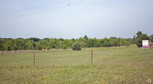
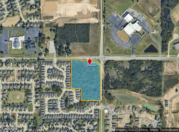
Property Record
129Th East Ave, Broken Arrow, OK 74011
NEARBY LISTINGS FOR SALE OR LEASE
Property Detail
129Th East Ave
Tulsa, OK
Unplatted
98429-84-29-00010
NE NE LESS N24.75 & W24.75 THEREOF & LESS BEG 24.75S & 24.75E NEC NE TH S419.19 N140.83 N178.89 NW105.91 W273.88 WLY201.59 E564.21 TO POB& LESS PRT NE NE BEG 659.77W NEC NE TH W659.77 S1321.49 E1319.87 N409.03 W448 N252 W211.85 N660.89 TO POB LESS N2
Agriculturalland
Tulsa
X
Oklahoma
40143C0389M
11.68 AC
2025
Southeast
2025
Tulsa
007531
DEMOGRAPHICS near 129Th East Ave
1 Mile
3 Mile
5 Mile
2024 Total Population
6,272
73,262
165,107
2029 Population
6,421
75,438
170,531
Pop Growth 2024-2029
+ 2.38%
+ 2.97%
+ 3.29%
Average Age
41
39
39
2024 Total Households
2,164
27,367
64,228
HH Growth 2024-2029
+ 2.50%
+ 3.01%
+ 3.29%
Median Household Inc
$96,682
$85,070
$78,468
Avg Household Size
2.80
2.60
2.50
2024 Avg HH Vehicles
2.00
2.00
2.00
Median Home Value
$248,659
$215,459
$229,990
Median Year Built
1997
1991
1989
Nearby Places
Map Layers
Map Styles
 Street
 Aerial
- Restaurants
- Banks
- Shops
- Fitness
- Groceries
PUBLIC TRANSPORTATION
AIRPORT
Tulsa International
DRIVE
WALK
Distance
Tulsa International
27 min
18.1 mi
Freight Ports
Tulsa Port Of Catoosa
DRIVE
WALK
Distance
Tulsa Port Of Catoosa
29 min
21.9 mi
Nearby Properties
Address
Land Use
TOTAL SIZE
Lot Size
Zoning
Address
Land Use
TOTAL SIZE
Lot Size
Zoning
323,882 SF
20 AC
CO
Address
Land Use
TOTAL SIZE
Lot Size
Zoning
157,138 SF
9.28 AC
CO
Address
Land Use
TOTAL SIZE
Lot Size
Zoning
390,154 SF
52.94 AC
A1
Address
Land Use
TOTAL SIZE
Lot Size
Zoning
134,232 SF
28.52 AC
R2
Address
Land Use
TOTAL SIZE
Lot Size
Zoning
90,533 SF
29.41 AC
A1
Address
Land Use
TOTAL SIZE
Lot Size
Zoning
176,243 SF
5.77 AC
CS
Address
Land Use
TOTAL SIZE
Lot Size
Zoning
152,422 SF
44.60 AC
AG
Address
Land Use
TOTAL SIZE
Lot Size
Zoning
37.23 AC
A1
Address
Land Use
TOTAL SIZE
Lot Size
Zoning
33,668 SF
8.04 AC
CO
Address
Land Use
TOTAL SIZE
Lot Size
Zoning
21,301 SF
3.94 AC
CN
Address
Land Use
TOTAL SIZE
Lot Size
Zoning
27,278 SF
2.49 AC
CS
Address
Land Use
TOTAL SIZE
Lot Size
Zoning
56,526 SF
25.18 AC
AG
Address
Land Use
TOTAL SIZE
Lot Size
Zoning
84,314 SF
12.05 AC
A1
Address
Land Use
TOTAL SIZE
Lot Size
Zoning
68,478 SF
9.27 AC
R1
Address
Land Use
TOTAL SIZE
Lot Size
Zoning
35,954 SF
27.97 AC
CN
Address
Land Use
TOTAL SIZE
Lot Size
Zoning
67,149 SF
28.56 AC
R2
Address
Land Use
TOTAL SIZE
Lot Size
Zoning
Address
Land Use
TOTAL SIZE
Lot Size
Zoning
260,059 SF
19.99 AC
CO
Address
Land Use
TOTAL SIZE
Lot Size
Zoning
71,362 SF
14.08 AC
RD
Address
Land Use
TOTAL SIZE
Lot Size
Zoning
22,594 SF
2.07 AC
ON
Address
Land Use
TOTAL SIZE
Lot Size
Zoning
39,733 SF
9.36 AC
A1
Address
Land Use
TOTAL SIZE
Lot Size
Zoning
20,292 SF
48.11 AC
CO
Address
Land Use
TOTAL SIZE
Lot Size
Zoning
60,790 SF
10.84 AC
R1
Address
Land Use
TOTAL SIZE
Lot Size
Zoning
330,744 SF
17.43 AC
RM3
Address
Land Use
TOTAL SIZE
Lot Size
Zoning
11,601 SF
38.18 AC
RS1
Address
Land Use
TOTAL SIZE
Lot Size
Zoning
356,659 SF
14.18 AC
CO
Address
Land Use
TOTAL SIZE
Lot Size
Zoning
37,750 SF
10.06 AC
CO
Address
Land Use
TOTAL SIZE
Lot Size
Zoning
178,999 SF
23.87 AC
CO
Address
Land Use
TOTAL SIZE
Lot Size
Zoning
49,090 SF
12.91 AC
OL
Address
Land Use
TOTAL SIZE
Lot Size
Zoning
37,075 SF
21.33 AC
AG
The World's #1 Commercial Real Estate Marketplace
Connect with us
© 2025 CoStar Group
The information above has been obtained from sources believed reliable. While we do not doubt its accuracy we have not verified it and make no guarantee, warranty or representation about it. It is your responsibility to independently confirm its accuracy and completeness. Any projections, opinions, assumptions, or estimates used are for example only and do not represent the current or future performance of the property. The value of this transaction to you depends on tax and other factors which should be evaluated by your tax, financial, and legal advisors. You and your advisors should conduct a careful, independent investigation of the property to determine to your satisfaction the suitability of the property for your needs.