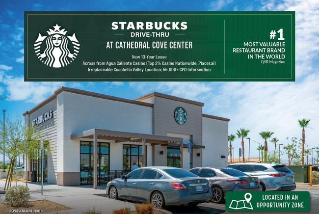
Property Record
68995 E Palm Canyon Dr, Cathedral City, CA 92234

NEARBY LISTINGS FOR SALE OR LEASE
Property Detail
68995 E Palm Canyon Dr
Riverside-San Bernardino-Ontario, CA
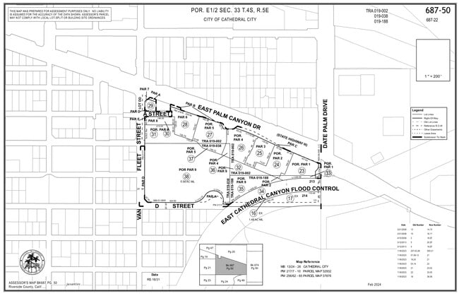
Parcel Map No. 37876
687-500-023
ACRES 0.65000000 ACREAGEQUALCODE ML LOTTYPE P PARCEL 1-P MAPPLATB 256 MAPPLATP 062 SUBDIVISIONNAME PM 37876
Restaurantbuilding
Riverside
2024
California
2025
0.65 AC
044933
Coachella Valley
1,925 SF
Inland Empire (California)
DEMOGRAPHICS near 68995 E Palm Canyon Dr
1 Mile
3 Mile
5 Mile
2024 Total Population
7,564
53,244
128,103
2029 Population
8,438
59,582
142,929
Pop Growth 2024-2029
+ 11.55%
+ 11.90%
+ 11.57%
Average Age
53
51
50
2024 Total Households
3,677
24,102
57,786
HH Growth 2024-2029
+ 10.91%
+ 12.90%
+ 12.28%
Median Household Inc
$53,474
$63,990
$70,296
Avg Household Size
2.00
2.20
2.10
2024 Avg HH Vehicles
2.00
2.00
2.00
Median Home Value
$485,877
$581,035
$577,698
Median Year Built
1983
1985
1985
Nearby Places
Map Layers
Map Styles
 Street
 Aerial
- Restaurants
- Banks
- Shops
- Fitness
- Groceries
PUBLIC TRANSPORTATION
AIRPORT
Palm Springs International
DRIVE
WALK
Distance
Palm Springs International
11 min
5.7 mi
Freight Ports
Port of San Diego
DRIVE
WALK
Distance
Port of San Diego
163 min
133.5 mi
SALE & LEASE HISTORY
LISTING DATE
SALE/LEASE

Sep 16, 2024
For Sale
Feb 12, 2025
For Sale
Nearby Properties
Address
Land Use
TOTAL SIZE
Lot Size
Zoning
Address
Land Use
TOTAL SIZE
Lot Size
Zoning
68.20 AC
Address
Land Use
TOTAL SIZE
Lot Size
Zoning
91,939 SF
8.80 AC
Address
Land Use
TOTAL SIZE
Lot Size
Zoning
Address
Land Use
TOTAL SIZE
Lot Size
Zoning
208,000 SF
16.04 AC
Address
Land Use
TOTAL SIZE
Lot Size
Zoning
322,000 SF
19.09 AC
Address
Land Use
TOTAL SIZE
Lot Size
Zoning
141,574 SF
44.60 AC
Address
Land Use
TOTAL SIZE
Lot Size
Zoning
Address
Land Use
TOTAL SIZE
Lot Size
Zoning
53,229 SF
8.80 AC
Address
Land Use
TOTAL SIZE
Lot Size
Zoning
41,962 SF
5 AC
Address
Land Use
TOTAL SIZE
Lot Size
Zoning
38,388 SF
8.31 AC
R3
Address
Land Use
TOTAL SIZE
Lot Size
Zoning
125,635 SF
4.75 AC
Address
Land Use
TOTAL SIZE
Lot Size
Zoning
66,732 SF
1.80 AC
PCC
Address
Land Use
TOTAL SIZE
Lot Size
Zoning
6,717 SF
17.79 AC
Address
Land Use
TOTAL SIZE
Lot Size
Zoning
73,256 SF
21.69 AC
R2-B
Address
Land Use
TOTAL SIZE
Lot Size
Zoning
144,780 SF
15.36 AC
Address
Land Use
TOTAL SIZE
Lot Size
Zoning
114,017 SF
7.91 AC
R1
Address
Land Use
TOTAL SIZE
Lot Size
Zoning
3,520 SF
2.63 AC
Address
Land Use
TOTAL SIZE
Lot Size
Zoning
102,304 SF
8.98 AC
CPS
Address
Land Use
TOTAL SIZE
Lot Size
Zoning
64,208 SF
9.26 AC
R3
Address
Land Use
TOTAL SIZE
Lot Size
Zoning
4,026 SF
9.49 AC
R204M
Address
Land Use
TOTAL SIZE
Lot Size
Zoning
46,528 SF
1.89 AC
CPS
Address
Land Use
TOTAL SIZE
Lot Size
Zoning
22,594 SF
1.37 AC
POC3
Address
Land Use
TOTAL SIZE
Lot Size
Zoning
Address
Land Use
TOTAL SIZE
Lot Size
Zoning
30,286 SF
18.84 AC
Address
Land Use
TOTAL SIZE
Lot Size
Zoning
43,336 SF
6.79 AC
PUDA
Address
Land Use
TOTAL SIZE
Lot Size
Zoning
62,769 SF
6.69 AC
Address
Land Use
TOTAL SIZE
Lot Size
Zoning
37,795 SF
21.83 AC
M1
Address
Land Use
TOTAL SIZE
Lot Size
Zoning
88,725 SF
17.31 AC
PCC
Address
Land Use
TOTAL SIZE
Lot Size
Zoning
The World's #1 Commercial Real Estate Marketplace
Connect with us
© 2025 CoStar Group
The information above has been obtained from sources believed reliable. While we do not doubt its accuracy we have not verified it and make no guarantee, warranty or representation about it. It is your responsibility to independently confirm its accuracy and completeness. Any projections, opinions, assumptions, or estimates used are for example only and do not represent the current or future performance of the property. The value of this transaction to you depends on tax and other factors which should be evaluated by your tax, financial, and legal advisors. You and your advisors should conduct a careful, independent investigation of the property to determine to your satisfaction the suitability of the property for your needs.