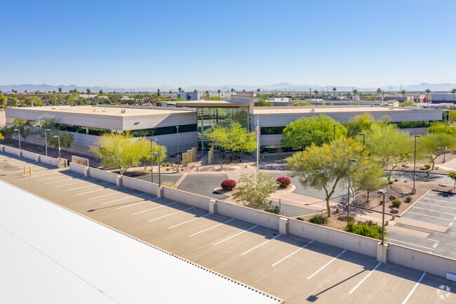
Property Record
8550 S Priest Dr, Tempe, AZ 85284

NEARBY LISTINGS FOR SALE OR LEASE
Property Detail
8550 S Priest Dr
Phoenix-Mesa-Chandler, AZ
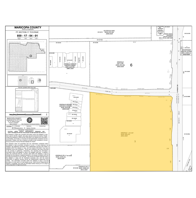
Emerald
301-54-807
EMERALD MCR 536-24
Officebuilding
Maricopa
A
Arizona
04013C2705L
3
2025
25.29 AC
2025
South Tempe/Ahwatukee
319910
Phoenix
283,782 SF
DEMOGRAPHICS near 8550 S Priest Dr
1 Mile
3 Mile
5 Mile
2024 Total Population
7,843
98,739
242,299
2029 Population
8,424
106,133
260,488
Pop Growth 2024-2029
+ 7.41%
+ 7.49%
+ 7.51%
Average Age
39
39
39
2024 Total Households
3,756
40,998
96,695
HH Growth 2024-2029
+ 7.48%
+ 7.61%
+ 7.61%
Median Household Inc
$78,058
$86,047
$85,483
Avg Household Size
2.10
2.40
2.40
2024 Avg HH Vehicles
2.00
2.00
2.00
Median Home Value
$400,693
$397,717
$392,606
Median Year Built
1993
1989
1986
Nearby Places
Map Layers
Map Styles
 Street
 Aerial
- Restaurants
- Banks
- Shops
- Fitness
- Groceries
PUBLIC TRANSPORTATION
AIRPORT
Phoenix Sky Harbor International
DRIVE
WALK
Distance
Phoenix Sky Harbor International
17 min
10.2 mi
Phoenix-Mesa Gateway
DRIVE
WALK
Distance
Phoenix-Mesa Gateway
32 min
22.1 mi
SALE & LEASE HISTORY
LISTING DATE
SALE/LEASE

Jun 18, 2025
For Lease
Jun 18, 2025
For Sale
Aug 19, 2025
For Sale
Nearby Properties
Address
Land Use
TOTAL SIZE
Lot Size
Zoning
Address
Land Use
TOTAL SIZE
Lot Size
Zoning
47,945 SF
8.35 AC
C-C
Address
Land Use
TOTAL SIZE
Lot Size
Zoning
1,149,733 SF
70.56 AC
PAD
Address
Land Use
TOTAL SIZE
Lot Size
Zoning
14.98 AC
I-1
Address
Land Use
TOTAL SIZE
Lot Size
Zoning
656,241 SF
29.09 AC
PAD
Address
Land Use
TOTAL SIZE
Lot Size
Zoning
1,085,359 SF
74.95 AC
PAD
Address
Land Use
TOTAL SIZE
Lot Size
Zoning
390,410 SF
47.65 AC
R-35
Address
Land Use
TOTAL SIZE
Lot Size
Zoning
442,642 SF
35.15 AC
GID
Address
Land Use
TOTAL SIZE
Lot Size
Zoning
586,083 SF
69.82 AC
Address
Land Use
TOTAL SIZE
Lot Size
Zoning
393,258 SF
49.79 AC
AG
Address
Land Use
TOTAL SIZE
Lot Size
Zoning
412,062 SF
21.84 AC
C-C
Address
Land Use
TOTAL SIZE
Lot Size
Zoning
415,228 SF
19.48 AC
I-1
Address
Land Use
TOTAL SIZE
Lot Size
Zoning
249,019 SF
23.96 AC
AG
Address
Land Use
TOTAL SIZE
Lot Size
Zoning
713,461 SF
38.66 AC
I-1
Address
Land Use
TOTAL SIZE
Lot Size
Zoning
309.82 AC
R-35
Address
Land Use
TOTAL SIZE
Lot Size
Zoning
409,148 SF
29.15 AC
I-1
Address
Land Use
TOTAL SIZE
Lot Size
Zoning
230,853 SF
23.41 AC
C-R
Address
Land Use
TOTAL SIZE
Lot Size
Zoning
300,965 SF
13.37 AC
PAD
Address
Land Use
TOTAL SIZE
Lot Size
Zoning
229,469 SF
23.78 AC
PAD
Address
Land Use
TOTAL SIZE
Lot Size
Zoning
569,902 SF
42.47 AC
I-1
Address
Land Use
TOTAL SIZE
Lot Size
Zoning
387,347 SF
18.83 AC
M-H
Address
Land Use
TOTAL SIZE
Lot Size
Zoning
39,250 SF
119.46 AC
R1-6
Address
Land Use
TOTAL SIZE
Lot Size
Zoning
369,672 SF
22.28 AC
M-H
Address
Land Use
TOTAL SIZE
Lot Size
Zoning
240,814 SF
22.70 AC
C2
Address
Land Use
TOTAL SIZE
Lot Size
Zoning
422,759 SF
22.23 AC
M-H
Address
Land Use
TOTAL SIZE
Lot Size
Zoning
480,044 SF
20.47 AC
R-3A
Address
Land Use
TOTAL SIZE
Lot Size
Zoning
391,186 SF
16.44 AC
M-H
Address
Land Use
TOTAL SIZE
Lot Size
Zoning
356,904 SF
18.74 AC
GID
Address
Land Use
TOTAL SIZE
Lot Size
Zoning
261.15 AC
RE-35
Address
Land Use
TOTAL SIZE
Lot Size
Zoning
306,300 SF
16.54 AC
PAD
The World's #1 Commercial Real Estate Marketplace
Connect with us
© 2026 CoStar Group
The information above has been obtained from sources believed reliable. While we do not doubt its accuracy we have not verified it and make no guarantee, warranty or representation about it. It is your responsibility to independently confirm its accuracy and completeness. Any projections, opinions, assumptions, or estimates used are for example only and do not represent the current or future performance of the property. The value of this transaction to you depends on tax and other factors which should be evaluated by your tax, financial, and legal advisors. You and your advisors should conduct a careful, independent investigation of the property to determine to your satisfaction the suitability of the property for your needs.