Property Record
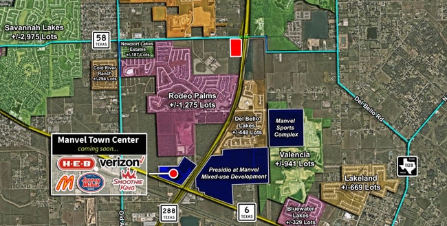
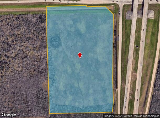
S Highway 288, Manvel, TX 77578
This Property Is For Sale
NEARBY LISTINGS FOR SALE OR LEASE
Property Detail
S Highway 288
Houston-The Woodlands-Sugar Land, TX
A C H & B
0459-0013-001
A0459 A C H & B TRACT 2A1 ACRES 24.7282 (MANVEL)
Agriculturalland
Brazoria
X
Texas
48039C0020K
24.73 AC
2024
South
2025
Houston
660708
DEMOGRAPHICS near S Highway 288
1 Mile
3 Mile
5 Mile
2024 Total Population
5,192
47,897
135,594
2029 Population
5,945
53,963
153,596
Pop Growth 2024-2029
+ 14.50%
+ 12.66%
+ 13.28%
Average Age
33
35
35
2024 Total Households
1,620
15,265
44,468
HH Growth 2024-2029
+ 14.63%
+ 12.79%
+ 13.29%
Median Household Inc
$92,968
$125,325
$105,492
Avg Household Size
3.20
3.10
3.00
2024 Avg HH Vehicles
2.00
2.00
2.00
Median Home Value
$301,215
$334,568
$314,667
Median Year Built
2011
2010
2007
Nearby Places
- Restaurants
- Banks
- Shops
- Fitness
- Groceries
PUBLIC TRANSPORTATION
AIRPORT
William P Hobby
DRIVE
WALK
Distance
William P Hobby
32 min
20.0 mi
George Bush Intcntl/Houston
DRIVE
WALK
Distance
George Bush Intcntl/Houston
47 min
40.7 mi
Nearby Properties
Address
Land Use
TOTAL SIZE
Lot Size
Zoning
Address
Land Use
TOTAL SIZE
Lot Size
Zoning
241,351 SF
60.11 AC
Address
Land Use
TOTAL SIZE
Lot Size
Zoning
367,766 SF
43.71 AC
Address
Land Use
TOTAL SIZE
Lot Size
Zoning
114.04 AC
Address
Land Use
TOTAL SIZE
Lot Size
Zoning
372,280 SF
14.70 AC
0021
Address
Land Use
TOTAL SIZE
Lot Size
Zoning
323,168 SF
12.80 AC
Address
Land Use
TOTAL SIZE
Lot Size
Zoning
379,493 SF
14.27 AC
Address
Land Use
TOTAL SIZE
Lot Size
Zoning
66,998 SF
11.34 AC
Address
Land Use
TOTAL SIZE
Lot Size
Zoning
115,423 SF
12.13 AC
Address
Land Use
TOTAL SIZE
Lot Size
Zoning
228,276 SF
9.43 AC
0036
Address
Land Use
TOTAL SIZE
Lot Size
Zoning
172,256 SF
6.13 AC
Address
Land Use
TOTAL SIZE
Lot Size
Zoning
70,033 SF
17.97 AC
Address
Land Use
TOTAL SIZE
Lot Size
Zoning
58,985 SF
4.34 AC
Address
Land Use
TOTAL SIZE
Lot Size
Zoning
152,722 SF
16.70 AC
Address
Land Use
TOTAL SIZE
Lot Size
Zoning
59,618 SF
4.50 AC
Address
Land Use
TOTAL SIZE
Lot Size
Zoning
49,404 SF
1.90 AC
Address
Land Use
TOTAL SIZE
Lot Size
Zoning
15.28 AC
0015
Address
Land Use
TOTAL SIZE
Lot Size
Zoning
13.85 AC
Address
Land Use
TOTAL SIZE
Lot Size
Zoning
67,748 SF
9.28 AC
Address
Land Use
TOTAL SIZE
Lot Size
Zoning
70,071 SF
45.52 AC
Address
Land Use
TOTAL SIZE
Lot Size
Zoning
140,662 SF
11.15 AC
Address
Land Use
TOTAL SIZE
Lot Size
Zoning
79,192 SF
9.36 AC
0029
Address
Land Use
TOTAL SIZE
Lot Size
Zoning
58,813 SF
6.36 AC
Address
Land Use
TOTAL SIZE
Lot Size
Zoning
174,454 SF
7.60 AC
Address
Land Use
TOTAL SIZE
Lot Size
Zoning
91,574 SF
Address
Land Use
TOTAL SIZE
Lot Size
Zoning
28,708 SF
9.57 AC
Address
Land Use
TOTAL SIZE
Lot Size
Zoning
44,736 SF
6.24 AC
Address
Land Use
TOTAL SIZE
Lot Size
Zoning
44,694 SF
4.75 AC
Address
Land Use
TOTAL SIZE
Lot Size
Zoning
44,735 SF
120.87 AC
0010
Address
Land Use
TOTAL SIZE
Lot Size
Zoning
28,143 SF
13.08 AC
Address
Land Use
TOTAL SIZE
Lot Size
Zoning
125,723 SF
2.63 AC
The World's #1 Commercial Real Estate Marketplace
Connect with us
© 2025 CoStar Group
The information above has been obtained from sources believed reliable. While we do not doubt its accuracy we have not verified it and make no guarantee, warranty or representation about it. It is your responsibility to independently confirm its accuracy and completeness. Any projections, opinions, assumptions, or estimates used are for example only and do not represent the current or future performance of the property. The value of this transaction to you depends on tax and other factors which should be evaluated by your tax, financial, and legal advisors. You and your advisors should conduct a careful, independent investigation of the property to determine to your satisfaction the suitability of the property for your needs.