Property Record
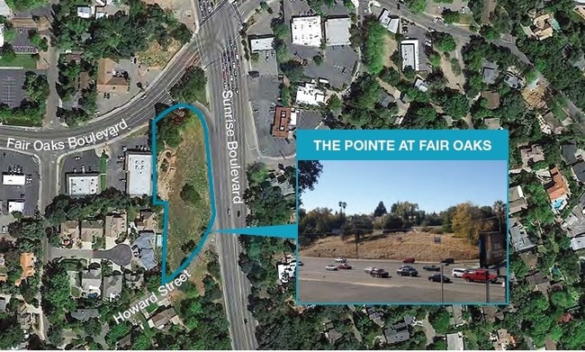
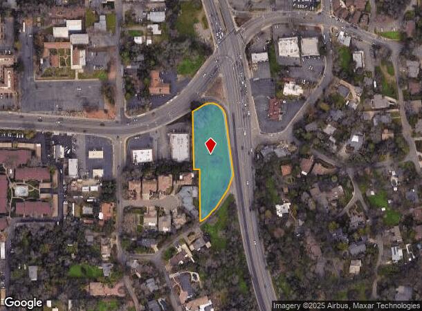
Fair Oaks Blvd, Fair Oaks, CA 95628

NEARBY LISTINGS FOR SALE OR LEASE
Property Detail
Fair Oaks Blvd
Sacramento--Roseville--Arden-Arcade, CA
Portofino Plaza
244-0220-026
PORTOFINO PLAZA, LOT 10
Commercialacreage
Sacramento
X
California
06067C0094H
10
2024
1.36 AC
2025
Carmichael/Fair Oaks
008008
Sacramento
DEMOGRAPHICS near Fair Oaks Blvd
1 Mile
3 Mile
5 Mile
2024 Total Population
8,719
100,842
292,347
2029 Population
8,787
101,365
293,699
Pop Growth 2024-2029
+ 0.78%
+ 0.52%
+ 0.46%
Average Age
46
43
41
2024 Total Households
3,819
41,004
115,396
HH Growth 2024-2029
+ 0.76%
+ 0.50%
+ 0.43%
Median Household Inc
$103,552
$90,314
$81,849
Avg Household Size
2.30
2.40
2.50
2024 Avg HH Vehicles
2.00
2.00
2.00
Median Home Value
$687,196
$534,266
$472,320
Median Year Built
1975
1975
1975
Nearby Places
- Restaurants
- Banks
- Shops
- Fitness
- Groceries
PUBLIC TRANSPORTATION
COMMUTER RAIL
Roseville (California Zephyr - Amtrak, Capitol Corridor - Amtrak)
DRIVE
WALK
Distance
Roseville (California Zephyr - Amtrak, Capitol Corridor - Amtrak)
20 min
9.9 mi
AIRPORT
Sacramento International
DRIVE
WALK
Distance
Sacramento International
34 min
22.2 mi
Freight Ports
Port of Stockton
DRIVE
WALK
Distance
Port of Stockton
73 min
62.0 mi
SALE & LEASE HISTORY
LISTING DATE
SALE/LEASE

Sep 24, 2016
For Sale
Apr 06, 2017
For Sale
Nearby Properties
Address
Land Use
TOTAL SIZE
Lot Size
Zoning
Address
Land Use
TOTAL SIZE
Lot Size
Zoning
SPA (ASPA)
Address
Land Use
TOTAL SIZE
Lot Size
Zoning
7.94 AC
RD-25
Address
Land Use
TOTAL SIZE
Lot Size
Zoning
251,225 SF
23.54 AC
SC
Address
Land Use
TOTAL SIZE
Lot Size
Zoning
199,580 SF
10.29 AC
RD20
Address
Land Use
TOTAL SIZE
Lot Size
Zoning
202,776 SF
12.17 AC
RD-25 (PC)
Address
Land Use
TOTAL SIZE
Lot Size
Zoning
241,672 SF
18.54 AC
SC
Address
Land Use
TOTAL SIZE
Lot Size
Zoning
99,408 SF
3.53 AC
BP
Address
Land Use
TOTAL SIZE
Lot Size
Zoning
12,548 SF
14.36 AC
RD-30
Address
Land Use
TOTAL SIZE
Lot Size
Zoning
156,365 SF
12.81 AC
SC
Address
Land Use
TOTAL SIZE
Lot Size
Zoning
84,387 SF
3.52 AC
LC
Address
Land Use
TOTAL SIZE
Lot Size
Zoning
166,268 SF
9.50 AC
RD30
Address
Land Use
TOTAL SIZE
Lot Size
Zoning
99,568 SF
10.92 AC
RD-5
Address
Land Use
TOTAL SIZE
Lot Size
Zoning
140,102 SF
3.30 AC
RD-20
Address
Land Use
TOTAL SIZE
Lot Size
Zoning
137,732 SF
12.87 AC
SC
Address
Land Use
TOTAL SIZE
Lot Size
Zoning
112,065 SF
8.52 AC
RD20
Address
Land Use
TOTAL SIZE
Lot Size
Zoning
78,379 SF
4.91 AC
RD20
Address
Land Use
TOTAL SIZE
Lot Size
Zoning
112,244 SF
3.55 AC
GC
Address
Land Use
TOTAL SIZE
Lot Size
Zoning
52,595 SF
4.48 AC
LC
Address
Land Use
TOTAL SIZE
Lot Size
Zoning
218,823 SF
10.77 AC
HDR
Address
Land Use
TOTAL SIZE
Lot Size
Zoning
85,320 SF
4 AC
SPA
Address
Land Use
TOTAL SIZE
Lot Size
Zoning
2,940 SF
4.97 AC
RD10
Address
Land Use
TOTAL SIZE
Lot Size
Zoning
105,703 SF
4.75 AC
RD-30 BP
Address
Land Use
TOTAL SIZE
Lot Size
Zoning
195,702 SF
3.66 AC
GC
Address
Land Use
TOTAL SIZE
Lot Size
Zoning
2.43 AC
GC
Address
Land Use
TOTAL SIZE
Lot Size
Zoning
135,053 SF
6.66 AC
LC SC RD-4
Address
Land Use
TOTAL SIZE
Lot Size
Zoning
157,500 SF
12.91 AC
OPMU
Address
Land Use
TOTAL SIZE
Lot Size
Zoning
124,339 SF
10.28 AC
RD-20
Address
Land Use
TOTAL SIZE
Lot Size
Zoning
4 AC
M-2 (NPA)
Address
Land Use
TOTAL SIZE
Lot Size
Zoning
57,465 SF
3 AC
RD-5
Address
Land Use
TOTAL SIZE
Lot Size
Zoning
67,724 SF
9.73 AC
SPA
The World's #1 Commercial Real Estate Marketplace
Connect with us
© 2025 CoStar Group
The information above has been obtained from sources believed reliable. While we do not doubt its accuracy we have not verified it and make no guarantee, warranty or representation about it. It is your responsibility to independently confirm its accuracy and completeness. Any projections, opinions, assumptions, or estimates used are for example only and do not represent the current or future performance of the property. The value of this transaction to you depends on tax and other factors which should be evaluated by your tax, financial, and legal advisors. You and your advisors should conduct a careful, independent investigation of the property to determine to your satisfaction the suitability of the property for your needs.