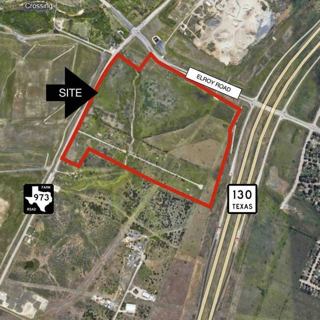
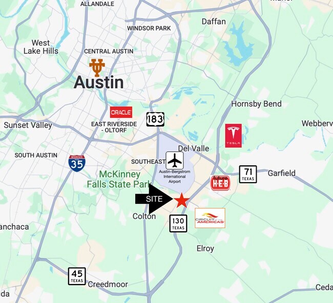
Property Record
S F M 973 Rd, Del Valle, TX 78617
Property Detail
S F M 973 Rd
Austin-Round Rock-San Marcos, TX
ABS 61 SUR 1 BAIN N M ACR 3.03
975447
TRAVIS
Vacantlandnec
Texas
2025
28.89 AC
2025
Southeast
002453
Austin
NEARBY LISTINGS FOR SALE OR LEASE
DEMOGRAPHICS near S F M 973 Rd
1 mile
3 mile
5 mile
2025 Total Population
1,718
17,052
55,665
2030 Population
1,803
18,326
59,939
Pop Growth 2025-2030
+ 4.95%
+ 7.47%
+ 7.68%
Average Age
36
35
35
2025 Total Households
474
4,826
17,525
HH Growth 2025-2030
+ 5.49%
+ 8.41%
+ 8.65%
Median Household Inc
$73,381
$95,097
$97,356
Avg Household Size
3.40
3.40
3.10
2025 Avg HH Vehicles
2.00
2.00
2.00
Median Home Value
$326,190
$337,175
$379,952
Median Year Built
1997
2010
2010
Nearby Places
Map Layers
Map Styles
 Street
 Aerial
Transit
 Traffic
 Biking
Places
Listings with unknown addresses are not visible on the map
- Restaurants
- Banks
- Shops
- Fitness
- Groceries
PUBLIC TRANSPORTATION
AIRPORT
Austin-Bergstrom International
Drive
Walk
Distance
Austin-Bergstrom International
10 min
3.4 mi
Freight Ports
Calhoun Port
Drive
Walk
Distance
Calhoun Port
175 min
147.3 mi
SALE & LEASE HISTORY
LISTING DATE
SALE/LEASE

May 07, 2024
For Sale
Nearby Properties
Address
Land Use
TOTAL SIZE
Lot Size
Zoning
Address
Land Use
TOTAL SIZE
Lot Size
Zoning
942.08 AC
Address
Land Use
TOTAL SIZE
Lot Size
Zoning
801,840 SF
63.90 AC
Address
Land Use
TOTAL SIZE
Lot Size
Zoning
602,470 SF
67.47 AC
Address
Land Use
TOTAL SIZE
Lot Size
Zoning
241,920 SF
23.37 AC
Address
Land Use
TOTAL SIZE
Lot Size
Zoning
562,830 SF
213.88 AC
Address
Land Use
TOTAL SIZE
Lot Size
Zoning
241,725 SF
16.76 AC
Address
Land Use
TOTAL SIZE
Lot Size
Zoning
231,000 SF
13.07 AC
Address
Land Use
TOTAL SIZE
Lot Size
Zoning
247,500 SF
15.78 AC
Address
Land Use
TOTAL SIZE
Lot Size
Zoning
198,000 SF
11.72 AC
Address
Land Use
TOTAL SIZE
Lot Size
Zoning
7,366 SF
88.64 AC
Address
Land Use
TOTAL SIZE
Lot Size
Zoning
356,800 SF
40.79 AC
Address
Land Use
TOTAL SIZE
Lot Size
Zoning
295,980 SF
47.98 AC
Address
Land Use
TOTAL SIZE
Lot Size
Zoning
4,843 SF
150.70 AC
Address
Land Use
TOTAL SIZE
Lot Size
Zoning
139,750 SF
50.37 AC
Address
Land Use
TOTAL SIZE
Lot Size
Zoning
Address
Land Use
TOTAL SIZE
Lot Size
Zoning
121,950 SF
11.92 AC
Address
Land Use
TOTAL SIZE
Lot Size
Zoning
157,500 SF
10.59 AC
Address
Land Use
TOTAL SIZE
Lot Size
Zoning
162,786 SF
15.43 AC
Address
Land Use
TOTAL SIZE
Lot Size
Zoning
152,817 SF
13.49 AC
Address
Land Use
TOTAL SIZE
Lot Size
Zoning
146,160 SF
8.53 AC
Address
Land Use
TOTAL SIZE
Lot Size
Zoning
407,700 SF
34.50 AC
Address
Land Use
TOTAL SIZE
Lot Size
Zoning
104,420 SF
23.55 AC
Address
Land Use
TOTAL SIZE
Lot Size
Zoning
116.40 AC
Address
Land Use
TOTAL SIZE
Lot Size
Zoning
141,960 SF
24.80 AC
Address
Land Use
TOTAL SIZE
Lot Size
Zoning
95,049 SF
15 AC
Address
Land Use
TOTAL SIZE
Lot Size
Zoning
131,893 SF
10.01 AC
Address
Land Use
TOTAL SIZE
Lot Size
Zoning
118,018 SF
8.90 AC
Address
Land Use
TOTAL SIZE
Lot Size
Zoning
126,304 SF
28.30 AC
Address
Land Use
TOTAL SIZE
Lot Size
Zoning
168,000 SF
11.79 AC
Address
Land Use
TOTAL SIZE
Lot Size
Zoning
56.32 AC
The World's #1 Commercial Real Estate Marketplace
Connect with us
© 2026 CoStar Group
The information above has been obtained from sources believed reliable. While we do not doubt its accuracy we have not verified it and make no guarantee, warranty or representation about it. It is your responsibility to independently confirm its accuracy and completeness. Any projections, opinions, assumptions, or estimates used are for example only and do not represent the current or future performance of the property. The value of this transaction to you depends on tax and other factors which should be evaluated by your tax, financial, and legal advisors. You and your advisors should conduct a careful, independent investigation of the property to determine to your satisfaction the suitability of the property for your needs.