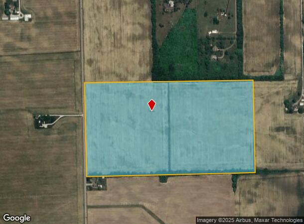
Property Record
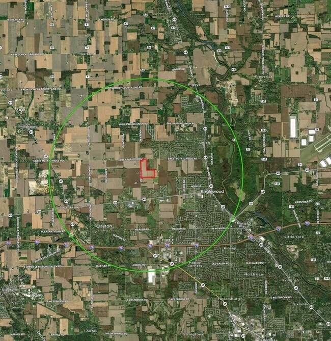
Sweet Potato Ridge Rd, Englewood, OH 45322

NEARBY LISTINGS FOR SALE OR LEASE
Property Detail
Sweet Potato Ridge Rd
M60-03012-0010
5-5-17
Farms
Montgomery
X
Ohio
39109C0240E
84.24 AC
2023
North Dayton
2024
Cincinnati/Dayton
125102
Dayton, OH
DEMOGRAPHICS near Sweet Potato Ridge Rd
1 Mile
3 Mile
5 Mile
2024 Total Population
2,324
18,612
40,235
2029 Population
2,286
18,324
39,855
Pop Growth 2024-2029
(1.64%)
(1.55%)
(0.94%)
Average Age
42
43
43
2024 Total Households
956
7,713
16,683
HH Growth 2024-2029
(1.67%)
(1.59%)
(0.88%)
Median Household Inc
$72,275
$73,276
$74,274
Avg Household Size
2.40
2.40
2.40
2024 Avg HH Vehicles
2.00
2.00
2.00
Median Home Value
$196,355
$186,588
$194,224
Median Year Built
1976
1973
1972
Nearby Places
Map Layers
Map Styles
 Street
 Aerial
- Restaurants
- Banks
- Shops
- Fitness
- Groceries
PUBLIC TRANSPORTATION
AIRPORT
James M Cox Dayton International
DRIVE
WALK
Distance
James M Cox Dayton International
17 min
8.8 mi
Freight Ports
Port of Toledo
DRIVE
WALK
Distance
Port of Toledo
182 min
153.5 mi
Nearby Properties
Address
Land Use
TOTAL SIZE
Lot Size
Zoning
Address
Land Use
TOTAL SIZE
Lot Size
Zoning
1,545,368 SF
162.29 AC
Address
Land Use
TOTAL SIZE
Lot Size
Zoning
52.03 AC
Address
Land Use
TOTAL SIZE
Lot Size
Zoning
Address
Land Use
TOTAL SIZE
Lot Size
Zoning
23,020 SF
15.14 AC
Address
Land Use
TOTAL SIZE
Lot Size
Zoning
25.82 AC
Address
Land Use
TOTAL SIZE
Lot Size
Zoning
252,449 SF
19.41 AC
Address
Land Use
TOTAL SIZE
Lot Size
Zoning
82,155 SF
7.85 AC
Address
Land Use
TOTAL SIZE
Lot Size
Zoning
212,060 SF
29.77 AC
Address
Land Use
TOTAL SIZE
Lot Size
Zoning
4.37 AC
Address
Land Use
TOTAL SIZE
Lot Size
Zoning
125,183 SF
10.51 AC
Address
Land Use
TOTAL SIZE
Lot Size
Zoning
87,797 SF
43.13 AC
Address
Land Use
TOTAL SIZE
Lot Size
Zoning
11,282 SF
11.60 AC
Address
Land Use
TOTAL SIZE
Lot Size
Zoning
107,907 SF
20.54 AC
Address
Land Use
TOTAL SIZE
Lot Size
Zoning
9.36 AC
Address
Land Use
TOTAL SIZE
Lot Size
Zoning
196,976 SF
20.24 AC
Address
Land Use
TOTAL SIZE
Lot Size
Zoning
81,471 SF
9.92 AC
Address
Land Use
TOTAL SIZE
Lot Size
Zoning
24,264 SF
5.72 AC
Address
Land Use
TOTAL SIZE
Lot Size
Zoning
70,388 SF
6 AC
Address
Land Use
TOTAL SIZE
Lot Size
Zoning
Address
Land Use
TOTAL SIZE
Lot Size
Zoning
69,738 SF
5.98 AC
Address
Land Use
TOTAL SIZE
Lot Size
Zoning
18,750 SF
2.87 AC
Address
Land Use
TOTAL SIZE
Lot Size
Zoning
7,396 SF
4.84 AC
Address
Land Use
TOTAL SIZE
Lot Size
Zoning
60,293 SF
10 AC
Address
Land Use
TOTAL SIZE
Lot Size
Zoning
108,525 SF
19.56 AC
Address
Land Use
TOTAL SIZE
Lot Size
Zoning
88,900 SF
9.70 AC
Address
Land Use
TOTAL SIZE
Lot Size
Zoning
18,348 SF
7.88 AC
Address
Land Use
TOTAL SIZE
Lot Size
Zoning
132,723 SF
14.99 AC
Address
Land Use
TOTAL SIZE
Lot Size
Zoning
10.13 AC
Address
Land Use
TOTAL SIZE
Lot Size
Zoning
19,750 SF
6 AC
Address
Land Use
TOTAL SIZE
Lot Size
Zoning
2,762 SF
1.35 AC
The World's #1 Commercial Real Estate Marketplace
Connect with us
© 2025 CoStar Group
The information above has been obtained from sources believed reliable. While we do not doubt its accuracy we have not verified it and make no guarantee, warranty or representation about it. It is your responsibility to independently confirm its accuracy and completeness. Any projections, opinions, assumptions, or estimates used are for example only and do not represent the current or future performance of the property. The value of this transaction to you depends on tax and other factors which should be evaluated by your tax, financial, and legal advisors. You and your advisors should conduct a careful, independent investigation of the property to determine to your satisfaction the suitability of the property for your needs.