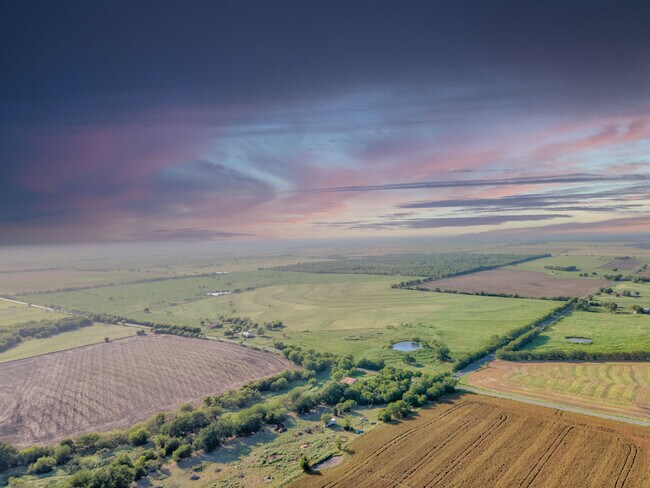
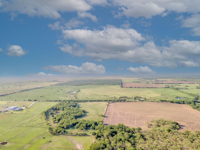
Property Record
Swindle Rd, Whitesboro, TX 76273

Property Detail
Swindle Rd
Sherman-Denison, TX
G-1253 TOBY THOMAS A-G1253, ACRES 196.1
124586
GRAYSON
Agriculturalland
Texas
B and X Area of moderate flood hazard, usually the area between the limits of the 100-year and 500-year floods.
196.10 AC
2024
Whitesboro
2025
Other Market Areas
001104
NEARBY LISTINGS FOR SALE OR LEASE
DEMOGRAPHICS near Swindle Rd
1 mile
3 mile
5 mile
2025 Total Population
125
715
2,274
2030 Population
134
766
2,441
Pop Growth 2025-2030
+ 7.20%
+ 7.13%
+ 7.34%
Average Age
40
41
41
2025 Total Households
47
259
825
HH Growth 2025-2030
+ 6.38%
+ 7.34%
+ 7.39%
Median Household Inc
$117,499
$109,523
$99,999
Avg Household Size
2.70
2.70
2.70
2025 Avg HH Vehicles
2.00
2.00
2.00
Median Home Value
$387,499
$367,307
$343,382
Median Year Built
2010
2001
1997
Nearby Places
Map Layers
Map Styles
 Street
 Aerial
Transit
 Traffic
 Biking
Places
Listings with unknown addresses are not visible on the map
- Restaurants
- Banks
- Shops
- Fitness
- Groceries
SALE & LEASE HISTORY
LISTING DATE
SALE/LEASE

Jul 18, 2023
For Sale
Nearby Properties
Address
Land Use
TOTAL SIZE
Lot Size
Zoning
Address
Land Use
TOTAL SIZE
Lot Size
Zoning
64,704 SF
12.90 AC
Address
Land Use
TOTAL SIZE
Lot Size
Zoning
16,077 SF
19.80 AC
Address
Land Use
TOTAL SIZE
Lot Size
Zoning
6,404 SF
21 AC
Address
Land Use
TOTAL SIZE
Lot Size
Zoning
26,640 SF
2.98 AC
Address
Land Use
TOTAL SIZE
Lot Size
Zoning
12,716 SF
12.18 AC
Address
Land Use
TOTAL SIZE
Lot Size
Zoning
12,376 SF
1.15 AC
Address
Land Use
TOTAL SIZE
Lot Size
Zoning
3,433 SF
23 AC
Address
Land Use
TOTAL SIZE
Lot Size
Zoning
2,700 SF
13.56 AC
Address
Land Use
TOTAL SIZE
Lot Size
Zoning
3,220 SF
7.11 AC
Address
Land Use
TOTAL SIZE
Lot Size
Zoning
2,136 SF
68.95 AC
Address
Land Use
TOTAL SIZE
Lot Size
Zoning
3,080 SF
176.68 AC
Address
Land Use
TOTAL SIZE
Lot Size
Zoning
2,362 SF
19.99 AC
Address
Land Use
TOTAL SIZE
Lot Size
Zoning
2,200 SF
13.50 AC
Address
Land Use
TOTAL SIZE
Lot Size
Zoning
2,321 SF
4 AC
Address
Land Use
TOTAL SIZE
Lot Size
Zoning
1,632 SF
12.05 AC
Address
Land Use
TOTAL SIZE
Lot Size
Zoning
2,885 SF
20 AC
Address
Land Use
TOTAL SIZE
Lot Size
Zoning
1,680 SF
45.21 AC
Address
Land Use
TOTAL SIZE
Lot Size
Zoning
1,638 SF
16.01 AC
Address
Land Use
TOTAL SIZE
Lot Size
Zoning
2,324 SF
19 AC
Address
Land Use
TOTAL SIZE
Lot Size
Zoning
1,740 SF
1,222.79 AC
Address
Land Use
TOTAL SIZE
Lot Size
Zoning
6,372 SF
2 AC
Address
Land Use
TOTAL SIZE
Lot Size
Zoning
Address
Land Use
TOTAL SIZE
Lot Size
Zoning
Address
Land Use
TOTAL SIZE
Lot Size
Zoning
Address
Land Use
TOTAL SIZE
Lot Size
Zoning
2,409 SF
9.99 AC
Address
Land Use
TOTAL SIZE
Lot Size
Zoning
1,514 SF
19.29 AC
Address
Land Use
TOTAL SIZE
Lot Size
Zoning
1,693 SF
20 AC
Address
Land Use
TOTAL SIZE
Lot Size
Zoning
2,248 SF
19.88 AC
Address
Land Use
TOTAL SIZE
Lot Size
Zoning
1,541 SF
5.27 AC
Address
Land Use
TOTAL SIZE
Lot Size
Zoning
2,400 SF
0.25 AC
The World's #1 Commercial Real Estate Marketplace
Connect with us
© 2026 CoStar Group
The information above has been obtained from sources believed reliable. While we do not doubt its accuracy we have not verified it and make no guarantee, warranty or representation about it. It is your responsibility to independently confirm its accuracy and completeness. Any projections, opinions, assumptions, or estimates used are for example only and do not represent the current or future performance of the property. The value of this transaction to you depends on tax and other factors which should be evaluated by your tax, financial, and legal advisors. You and your advisors should conduct a careful, independent investigation of the property to determine to your satisfaction the suitability of the property for your needs.