Property Record
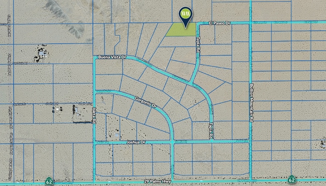
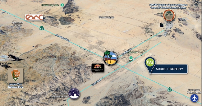
Tapia Rd, 29 Palms, CA 92277

This Property Is For Sale
NEARBY LISTINGS FOR SALE OR LEASE
Property Detail
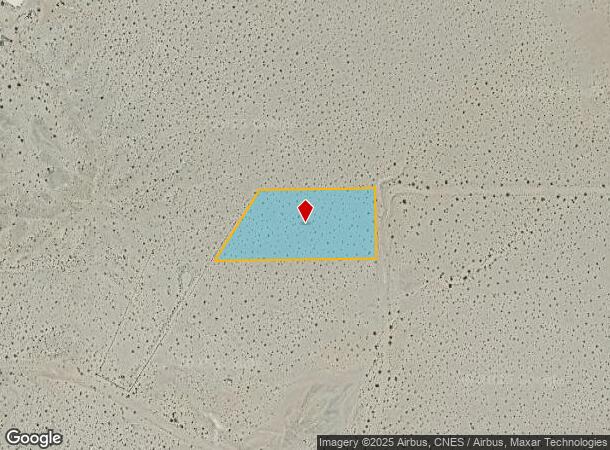
Tapia Rd
Riverside-San Bernardino-Ontario, CA
Palmetto Heights
0623-381-01
TRACT 6578 LOT 47 TRACT NO 6578 PALMETTO HEIGHTS LOT 47 EX MNL RTS RESERVATION OF RECORD
Vacantlandnec
San Bernardino
X
California
06071C8195J
47
2024
2.34 AC
2025
Twentynine Palms
010422
Inland Empire (California)
DEMOGRAPHICS near Tapia Rd
1 Mile
3 Mile
5 Mile
2024 Total Population
41
7,641
19,148
2029 Population
43
8,041
19,985
Pop Growth 2024-2029
+ 4.88%
+ 5.23%
+ 4.37%
Average Age
41
34
34
2024 Total Households
18
3,251
6,821
HH Growth 2024-2029
+ 5.56%
+ 5.26%
+ 4.93%
Median Household Inc
$103,125
$53,324
$56,937
Avg Household Size
2.20
2.30
2.50
2024 Avg HH Vehicles
2.00
2.00
2.00
Median Home Value
$212,500
$258,910
$296,823
Median Year Built
1964
1989
1986
Nearby Places
Map Layers
Map Styles
 Street
 Aerial
- Restaurants
- Banks
- Shops
- Fitness
- Groceries
Nearby Properties
Address
Land Use
TOTAL SIZE
Lot Size
Zoning
Address
Land Use
TOTAL SIZE
Lot Size
Zoning
448,671 SF
65.68 AC
Address
Land Use
TOTAL SIZE
Lot Size
Zoning
252,350 SF
29.43 AC
Address
Land Use
TOTAL SIZE
Lot Size
Zoning
45,360 SF
4.23 AC
Address
Land Use
TOTAL SIZE
Lot Size
Zoning
18,072 SF
1.38 AC
Address
Land Use
TOTAL SIZE
Lot Size
Zoning
2,000 SF
0.23 AC
Address
Land Use
TOTAL SIZE
Lot Size
Zoning
10,559 SF
1.11 AC
Address
Land Use
TOTAL SIZE
Lot Size
Zoning
45,226 SF
6.71 AC
Address
Land Use
TOTAL SIZE
Lot Size
Zoning
12,914 SF
17.06 AC
Address
Land Use
TOTAL SIZE
Lot Size
Zoning
9,370 SF
0.81 AC
Address
Land Use
TOTAL SIZE
Lot Size
Zoning
9,187 SF
31.13 AC
Address
Land Use
TOTAL SIZE
Lot Size
Zoning
18,790 SF
7.71 AC
Address
Land Use
TOTAL SIZE
Lot Size
Zoning
13,050 SF
15.10 AC
Address
Land Use
TOTAL SIZE
Lot Size
Zoning
27,264 SF
4.90 AC
Address
Land Use
TOTAL SIZE
Lot Size
Zoning
4,272 SF
0.93 AC
Address
Land Use
TOTAL SIZE
Lot Size
Zoning
4,980 SF
0.75 AC
Address
Land Use
TOTAL SIZE
Lot Size
Zoning
3,551 SF
11.70 AC
Address
Land Use
TOTAL SIZE
Lot Size
Zoning
4,054 SF
0.51 AC
Address
Land Use
TOTAL SIZE
Lot Size
Zoning
2,624 SF
0.76 AC
Address
Land Use
TOTAL SIZE
Lot Size
Zoning
4,000 SF
0.15 AC
Address
Land Use
TOTAL SIZE
Lot Size
Zoning
4,128 SF
0.37 AC
Address
Land Use
TOTAL SIZE
Lot Size
Zoning
6,777 SF
0.36 AC
Address
Land Use
TOTAL SIZE
Lot Size
Zoning
5,880 SF
0.83 AC
Address
Land Use
TOTAL SIZE
Lot Size
Zoning
4,704 SF
1.42 AC
Address
Land Use
TOTAL SIZE
Lot Size
Zoning
7,021 SF
2.72 AC
Address
Land Use
TOTAL SIZE
Lot Size
Zoning
8,578 SF
1.65 AC
Address
Land Use
TOTAL SIZE
Lot Size
Zoning
8,220 SF
1.19 AC
R3
Address
Land Use
TOTAL SIZE
Lot Size
Zoning
5,748 SF
0.94 AC
Address
Land Use
TOTAL SIZE
Lot Size
Zoning
5,040 SF
0.46 AC
Address
Land Use
TOTAL SIZE
Lot Size
Zoning
8,376 SF
0.75 AC
Address
Land Use
TOTAL SIZE
Lot Size
Zoning
2,808 SF
0.60 AC
The World's #1 Commercial Real Estate Marketplace
Connect with us
© 2025 CoStar Group
The information above has been obtained from sources believed reliable. While we do not doubt its accuracy we have not verified it and make no guarantee, warranty or representation about it. It is your responsibility to independently confirm its accuracy and completeness. Any projections, opinions, assumptions, or estimates used are for example only and do not represent the current or future performance of the property. The value of this transaction to you depends on tax and other factors which should be evaluated by your tax, financial, and legal advisors. You and your advisors should conduct a careful, independent investigation of the property to determine to your satisfaction the suitability of the property for your needs.