Property Record
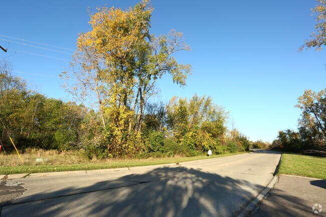
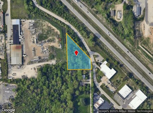
Taylor Dr, Flint, MI 48507
NEARBY LISTINGS FOR SALE OR LEASE
Property Detail
Taylor Dr
15-11-200-014
A PARCEL OF LAND BEG AT NE COR OF SEC TH W 293 FT TO C L OF DRAINAGE DITCH TH SLY 847.50 FT TH E 293 FT TH N 847.50 FT TO PL
Industrialacreage
Genesee
X
Michigan
26049C0304D
3.20 AC
2024
Flint
2025
Detroit
011010
Flint, MI
DEMOGRAPHICS near Taylor Dr
1 Mile
3 Mile
5 Mile
2024 Total Population
1,654
32,110
86,846
2029 Population
1,615
31,309
85,463
Pop Growth 2024-2029
(2.36%)
(2.49%)
(1.59%)
Average Age
43
40
39
2024 Total Households
765
13,968
36,332
HH Growth 2024-2029
(2.48%)
(2.61%)
(1.69%)
Median Household Inc
$56,147
$52,558
$48,022
Avg Household Size
2.10
2.20
2.30
2024 Avg HH Vehicles
2.00
2.00
2.00
Median Home Value
$165,398
$146,331
$132,543
Median Year Built
1973
1970
1966
Nearby Places
Map Layers
Map Styles
 Street
 Aerial
- Restaurants
- Banks
- Shops
- Fitness
- Groceries
PUBLIC TRANSPORTATION
COMMUTER RAIL
DRIVE
WALK
Distance
13 min
8.4 mi
AIRPORT
Bishop International
DRIVE
WALK
Distance
Bishop International
14 min
3.9 mi
SALE & LEASE HISTORY
LISTING DATE
SALE/LEASE

Oct 23, 2017
For Sale
Aug 08, 2018
For Sale
Nearby Properties
Address
Land Use
TOTAL SIZE
Lot Size
Zoning
Address
Land Use
TOTAL SIZE
Lot Size
Zoning
381,509 SF
371.45 AC
PC
Address
Land Use
TOTAL SIZE
Lot Size
Zoning
331,630 SF
63.88 AC
MDM
Address
Land Use
TOTAL SIZE
Lot Size
Zoning
Address
Land Use
TOTAL SIZE
Lot Size
Zoning
51.26 AC
HDM
Address
Land Use
TOTAL SIZE
Lot Size
Zoning
295,620 SF
25.62 AC
MDM
Address
Land Use
TOTAL SIZE
Lot Size
Zoning
33.65 AC
MDM
Address
Land Use
TOTAL SIZE
Lot Size
Zoning
911,140 SF
Address
Land Use
TOTAL SIZE
Lot Size
Zoning
260,000 SF
15.55 AC
PC
Address
Land Use
TOTAL SIZE
Lot Size
Zoning
120,487 SF
5.81 AC
PRC
Address
Land Use
TOTAL SIZE
Lot Size
Zoning
223,683 SF
24.88 AC
MDM
Address
Land Use
TOTAL SIZE
Lot Size
Zoning
141,748 SF
8.80 AC
MDM
Address
Land Use
TOTAL SIZE
Lot Size
Zoning
315,700 SF
38.97 AC
RM-2
Address
Land Use
TOTAL SIZE
Lot Size
Zoning
401,680 SF
20.41 AC
PC
Address
Land Use
TOTAL SIZE
Lot Size
Zoning
65,746 SF
3.97 AC
C-4
Address
Land Use
TOTAL SIZE
Lot Size
Zoning
Address
Land Use
TOTAL SIZE
Lot Size
Zoning
45,204 SF
6.43 AC
M-M
Address
Land Use
TOTAL SIZE
Lot Size
Zoning
104,040 SF
17.02 AC
MDM
Address
Land Use
TOTAL SIZE
Lot Size
Zoning
406,416 SF
21.10 AC
PC
Address
Land Use
TOTAL SIZE
Lot Size
Zoning
75,536 SF
8.97 AC
PRC
Address
Land Use
TOTAL SIZE
Lot Size
Zoning
69,232 SF
2.75 AC
C-3A
Address
Land Use
TOTAL SIZE
Lot Size
Zoning
131,682 SF
11.51 AC
MDM
Address
Land Use
TOTAL SIZE
Lot Size
Zoning
100,000 SF
Address
Land Use
TOTAL SIZE
Lot Size
Zoning
15.19 AC
M-M
Address
Land Use
TOTAL SIZE
Lot Size
Zoning
58,648 SF
5.80 AC
OS
Address
Land Use
TOTAL SIZE
Lot Size
Zoning
100,750 SF
Address
Land Use
TOTAL SIZE
Lot Size
Zoning
9.88 AC
HDM
Address
Land Use
TOTAL SIZE
Lot Size
Zoning
118,750 SF
21.26 AC
C-3A
Address
Land Use
TOTAL SIZE
Lot Size
Zoning
38,289 SF
6.93 AC
C-3A
Address
Land Use
TOTAL SIZE
Lot Size
Zoning
64,150 SF
3.64 AC
PRC
Address
Land Use
TOTAL SIZE
Lot Size
Zoning
41,508 SF
5.27 AC
OS
The World's #1 Commercial Real Estate Marketplace
Connect with us
© 2026 CoStar Group
The information above has been obtained from sources believed reliable. While we do not doubt its accuracy we have not verified it and make no guarantee, warranty or representation about it. It is your responsibility to independently confirm its accuracy and completeness. Any projections, opinions, assumptions, or estimates used are for example only and do not represent the current or future performance of the property. The value of this transaction to you depends on tax and other factors which should be evaluated by your tax, financial, and legal advisors. You and your advisors should conduct a careful, independent investigation of the property to determine to your satisfaction the suitability of the property for your needs.