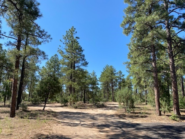
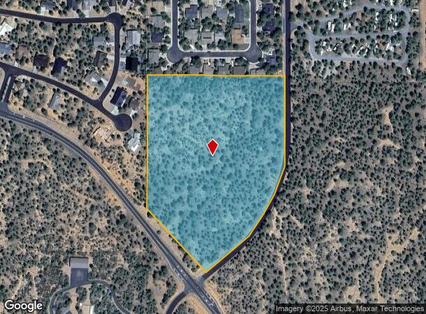
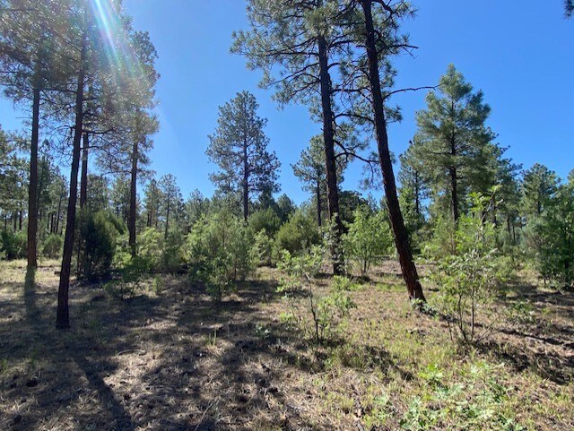
Property Record
S Central Ave, Show Low, AZ 85901
NEARBY LISTINGS FOR SALE OR LEASE
Property Detail
S Central Ave
210-01-037R
SECTION 29, T10N, R22E: COMM N1/16 COR SEC 29; TH S89*4247 W 25 TPOB; TH S0*1622 E 221.04; TH SWLY ALG CURVE (R=725) 644.30; TH S50*3843 W 131.36; TH WLY ALG CURVE (R=25) 39.27; TH N39* 2117 W 360.64; TH N0*1649 W 582.89; TH N89*4247 E 632.51 TP OB.
Vacantlandnec
Navajo
X
Arizona
04017C4706E
10.17 AC
2024
Arizona Northeast & Holbrook Area
2026
Other Market Areas
965202
Show Low, AZ
DEMOGRAPHICS near S Central Ave
1 Mile
3 Mile
5 Mile
2024 Total Population
4,229
14,516
21,850
2029 Population
4,471
15,807
23,871
Pop Growth 2024-2029
+ 5.72%
+ 8.89%
+ 9.25%
Average Age
37
42
44
2024 Total Households
1,590
5,860
8,887
HH Growth 2024-2029
+ 5.60%
+ 8.84%
+ 9.25%
Median Household Inc
$58,525
$57,983
$56,714
Avg Household Size
2.60
2.40
2.40
2024 Avg HH Vehicles
2.00
2.00
2.00
Median Home Value
$218,825
$226,050
$235,916
Median Year Built
1990
1998
1998
Nearby Places
- Restaurants
- Banks
- Shops
- Fitness
- Groceries
SALE & LEASE HISTORY
LISTING DATE
SALE/LEASE

Oct 03, 2023
For Sale
Nearby Properties
Address
Land Use
TOTAL SIZE
Lot Size
Zoning
Address
Land Use
TOTAL SIZE
Lot Size
Zoning
147,745 SF
12.70 AC
MUNICIPAL
Address
Land Use
TOTAL SIZE
Lot Size
Zoning
203,623 SF
14 AC
MUNICIPAL
Address
Land Use
TOTAL SIZE
Lot Size
Zoning
138,315 SF
13.91 AC
MUNICIPAL
Address
Land Use
TOTAL SIZE
Lot Size
Zoning
81,647 SF
4.47 AC
MUNICIPAL
Address
Land Use
TOTAL SIZE
Lot Size
Zoning
74,338 SF
2.29 AC
Address
Land Use
TOTAL SIZE
Lot Size
Zoning
56,331 SF
16.30 AC
MUNICIPAL
Address
Land Use
TOTAL SIZE
Lot Size
Zoning
56,032 SF
4.60 AC
MUNICIPAL
Address
Land Use
TOTAL SIZE
Lot Size
Zoning
97,790 SF
4.80 AC
MUNICIPAL
Address
Land Use
TOTAL SIZE
Lot Size
Zoning
32,308 SF
10.46 AC
MUNICIPAL
Address
Land Use
TOTAL SIZE
Lot Size
Zoning
55,237 SF
6.03 AC
MUNICIPAL
Address
Land Use
TOTAL SIZE
Lot Size
Zoning
86,443 SF
6.85 AC
MUNICIPAL
Address
Land Use
TOTAL SIZE
Lot Size
Zoning
30,952 SF
5.72 AC
MUNICIPAL
Address
Land Use
TOTAL SIZE
Lot Size
Zoning
89,607 SF
5.78 AC
Address
Land Use
TOTAL SIZE
Lot Size
Zoning
29,707 SF
3 AC
MUNICIPAL
Address
Land Use
TOTAL SIZE
Lot Size
Zoning
32,762 SF
1.95 AC
MUNICIPAL
Address
Land Use
TOTAL SIZE
Lot Size
Zoning
30,942 SF
3.21 AC
MUNICIPAL
Address
Land Use
TOTAL SIZE
Lot Size
Zoning
46,700 SF
2.51 AC
MUNICIPAL
Address
Land Use
TOTAL SIZE
Lot Size
Zoning
33,421 SF
5.84 AC
MUNICIPAL
Address
Land Use
TOTAL SIZE
Lot Size
Zoning
19,280 SF
6.14 AC
MUNICIPAL
Address
Land Use
TOTAL SIZE
Lot Size
Zoning
47,586 SF
3.50 AC
MUNICIPAL
Address
Land Use
TOTAL SIZE
Lot Size
Zoning
76,060 SF
4.69 AC
MUNICIPAL
Address
Land Use
TOTAL SIZE
Lot Size
Zoning
8 AC
MUNICIPAL
Address
Land Use
TOTAL SIZE
Lot Size
Zoning
62,331 SF
4.20 AC
MUNICIPAL
Address
Land Use
TOTAL SIZE
Lot Size
Zoning
22,400 SF
2.55 AC
MUNICIPAL
Address
Land Use
TOTAL SIZE
Lot Size
Zoning
35,090 SF
3.40 AC
MUNICIPAL
Address
Land Use
TOTAL SIZE
Lot Size
Zoning
26,513 SF
9.76 AC
MUNICIPAL
Address
Land Use
TOTAL SIZE
Lot Size
Zoning
89,607 SF
3.97 AC
Address
Land Use
TOTAL SIZE
Lot Size
Zoning
21,291 SF
1.80 AC
MUNICIPAL
Address
Land Use
TOTAL SIZE
Lot Size
Zoning
16,349 SF
3.68 AC
MUNICIPAL
The World's #1 Commercial Real Estate Marketplace
Connect with us
© 2025 CoStar Group
The information above has been obtained from sources believed reliable. While we do not doubt its accuracy we have not verified it and make no guarantee, warranty or representation about it. It is your responsibility to independently confirm its accuracy and completeness. Any projections, opinions, assumptions, or estimates used are for example only and do not represent the current or future performance of the property. The value of this transaction to you depends on tax and other factors which should be evaluated by your tax, financial, and legal advisors. You and your advisors should conduct a careful, independent investigation of the property to determine to your satisfaction the suitability of the property for your needs.