Property Record
M N M N F Rd, Coupland, TX 78615
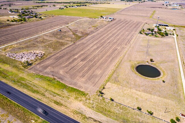

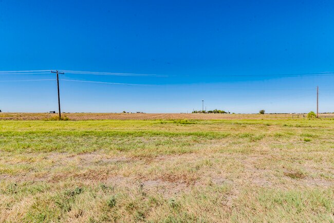
Property Detail
M N M N F Rd
Austin-Round Rock-San Marcos, TX
ABS 511 SUR 66 MCDOUGAL J ACR 12.893 (1-D-1)
914306
TRAVIS
Recreationalacreage
Texas
B and X Area of moderate flood hazard, usually the area between the limits of the 100-year and 500-year floods.
12.89 AC
2025
Far Northeast
2025
Austin
042500
NEARBY LISTINGS FOR SALE OR LEASE
DEMOGRAPHICS near M N M N F Rd
1 mile
3 mile
5 mile
2025 Total Population
169
950
12,073
2030 Population
191
1,083
13,192
Pop Growth 2025-2030
+ 13.02%
+ 14.00%
+ 9.27%
Average Age
40
40
37
2025 Total Households
54
322
3,906
HH Growth 2025-2030
+ 12.96%
+ 14.60%
+ 10.04%
Median Household Inc
$122,655
$111,153
$127,638
Avg Household Size
2.70
2.80
3.00
2025 Avg HH Vehicles
2.00
2.00
2.00
Median Home Value
$571,428
$432,203
$473,387
Median Year Built
2010
2010
2011
Nearby Places
Map Layers
Map Styles
 Street
 Aerial
Transit
 Traffic
 Biking
Places
Listings with unknown addresses are not visible on the map
- Restaurants
- Banks
- Shops
- Fitness
- Groceries
PUBLIC TRANSPORTATION
AIRPORT
Austin-Bergstrom International
Drive
Walk
Distance
Austin-Bergstrom International
43 min
27.2 mi
Freight Ports
Calhoun Port
Drive
Walk
Distance
Calhoun Port
204 min
170.2 mi
SALE & LEASE HISTORY
LISTING DATE
SALE/LEASE

May 09, 2024
For Sale
Nearby Properties
Address
Land Use
TOTAL SIZE
Lot Size
Zoning
Address
Land Use
TOTAL SIZE
Lot Size
Zoning
1,040 SF
319.09 AC
Address
Land Use
TOTAL SIZE
Lot Size
Zoning
247.08 AC
Address
Land Use
TOTAL SIZE
Lot Size
Zoning
211.51 AC
Address
Land Use
TOTAL SIZE
Lot Size
Zoning
186.19 AC
Address
Land Use
TOTAL SIZE
Lot Size
Zoning
2,020 SF
44.89 AC
Address
Land Use
TOTAL SIZE
Lot Size
Zoning
6,101 SF
11.66 AC
Address
Land Use
TOTAL SIZE
Lot Size
Zoning
78.13 AC
Address
Land Use
TOTAL SIZE
Lot Size
Zoning
1,835 SF
71.65 AC
Address
Land Use
TOTAL SIZE
Lot Size
Zoning
1,218 SF
18.01 AC
Address
Land Use
TOTAL SIZE
Lot Size
Zoning
56.15 AC
Address
Land Use
TOTAL SIZE
Lot Size
Zoning
3,945 SF
28.28 AC
Address
Land Use
TOTAL SIZE
Lot Size
Zoning
46.75 AC
Address
Land Use
TOTAL SIZE
Lot Size
Zoning
7,333 SF
84.11 AC
Address
Land Use
TOTAL SIZE
Lot Size
Zoning
7,658 SF
94.14 AC
Address
Land Use
TOTAL SIZE
Lot Size
Zoning
7,560 SF
4.21 AC
Address
Land Use
TOTAL SIZE
Lot Size
Zoning
14.58 AC
Address
Land Use
TOTAL SIZE
Lot Size
Zoning
4,167 SF
16.58 AC
Address
Land Use
TOTAL SIZE
Lot Size
Zoning
3,594 SF
10 AC
Address
Land Use
TOTAL SIZE
Lot Size
Zoning
2,953 SF
9.99 AC
Address
Land Use
TOTAL SIZE
Lot Size
Zoning
2,412 SF
25 AC
Address
Land Use
TOTAL SIZE
Lot Size
Zoning
6,877 SF
50.01 AC
Address
Land Use
TOTAL SIZE
Lot Size
Zoning
2 SF
10.33 AC
Address
Land Use
TOTAL SIZE
Lot Size
Zoning
6,398 SF
10.01 AC
Address
Land Use
TOTAL SIZE
Lot Size
Zoning
6,950 SF
174.36 AC
Address
Land Use
TOTAL SIZE
Lot Size
Zoning
2,132 SF
20.31 AC
Address
Land Use
TOTAL SIZE
Lot Size
Zoning
2,022 SF
10 AC
Address
Land Use
TOTAL SIZE
Lot Size
Zoning
2,112 SF
4.06 AC
Address
Land Use
TOTAL SIZE
Lot Size
Zoning
4,641 SF
2.49 AC
Address
Land Use
TOTAL SIZE
Lot Size
Zoning
23.70 AC
Address
Land Use
TOTAL SIZE
Lot Size
Zoning
26.96 AC
The World's #1 Commercial Real Estate Marketplace
Connect with us
© 2026 CoStar Group
The information above has been obtained from sources believed reliable. While we do not doubt its accuracy we have not verified it and make no guarantee, warranty or representation about it. It is your responsibility to independently confirm its accuracy and completeness. Any projections, opinions, assumptions, or estimates used are for example only and do not represent the current or future performance of the property. The value of this transaction to you depends on tax and other factors which should be evaluated by your tax, financial, and legal advisors. You and your advisors should conduct a careful, independent investigation of the property to determine to your satisfaction the suitability of the property for your needs.