Property Record
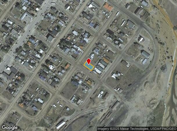
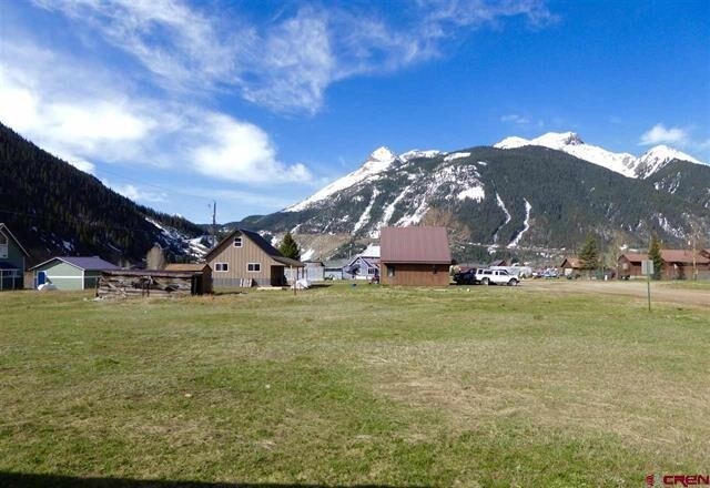
Tbd Mineral St (Between 10Th & 11Th Streets), Silverton, CO 81433

NEARBY LISTINGS FOR SALE OR LEASE
-
-
View all Silverton listings for sale on LoopNet.com
Property Detail
Tbd Mineral St (Between 10Th & 11Th Streets)
Other Market Areas
Town Silverton
48291730340012
BLOCK 34 LOTS 11-12
Residentialacreage
San Juan
X
Colorado
08111C0116C
11,12
2024
0.12 AC
2024
Colorado Southwest Area
972600
DEMOGRAPHICS near Tbd Mineral St (Between 10Th & 11Th Streets)
1 Mile
3 Mile
5 Mile
2024 Total Population
840
848
852
2029 Population
1,159
1,170
1,176
Pop Growth 2024-2029
+ 37.98%
+ 37.97%
+ 38.03%
Average Age
46
46
46
2024 Total Households
434
438
440
HH Growth 2024-2029
+ 35.71%
+ 35.84%
+ 35.91%
Median Household Inc
$64,387
$64,387
$64,387
Avg Household Size
1.90
1.90
1.90
2024 Avg HH Vehicles
2.00
2.00
2.00
Median Home Value
$415,517
$415,254
$416,102
Median Year Built
1977
1977
1977
Nearby Places
Map Layers
Map Styles
 Street
 Aerial
- Restaurants
- Banks
- Shops
- Fitness
- Groceries
SALE & LEASE HISTORY
LISTING DATE
SALE/LEASE

Sep 26, 2017
For Sale
Nearby Properties
Address
Land Use
TOTAL SIZE
Lot Size
Zoning
Address
Land Use
TOTAL SIZE
Lot Size
Zoning
3,648 SF
1.37 AC
Address
Land Use
TOTAL SIZE
Lot Size
Zoning
2,500 SF
0.17 AC
BP
Address
Land Use
TOTAL SIZE
Lot Size
Zoning
400 SF
9.04 AC
P
Address
Land Use
TOTAL SIZE
Lot Size
Zoning
3,000 SF
Address
Land Use
TOTAL SIZE
Lot Size
Zoning
9.04 AC
P
Address
Land Use
TOTAL SIZE
Lot Size
Zoning
9,000 SF
0.23 AC
R1
Address
Land Use
TOTAL SIZE
Lot Size
Zoning
2,491 SF
0.17 AC
BP
Address
Land Use
TOTAL SIZE
Lot Size
Zoning
4,400 SF
0.66 AC
Address
Land Use
TOTAL SIZE
Lot Size
Zoning
28,250 SF
0.23 AC
BP
Address
Land Use
TOTAL SIZE
Lot Size
Zoning
122,400 SF
14.98 AC
Address
Land Use
TOTAL SIZE
Lot Size
Zoning
7,712 SF
0.44 AC
BP
Address
Land Use
TOTAL SIZE
Lot Size
Zoning
7,200 SF
0.28 AC
P
Address
Land Use
TOTAL SIZE
Lot Size
Zoning
10,000 SF
0.23 AC
BP
Address
Land Use
TOTAL SIZE
Lot Size
Zoning
4,000 SF
0.12 AC
R2
Address
Land Use
TOTAL SIZE
Lot Size
Zoning
12,773 SF
0.33 AC
Address
Land Use
TOTAL SIZE
Lot Size
Zoning
1,250 SF
0.12 AC
Address
Land Use
TOTAL SIZE
Lot Size
Zoning
2,000 SF
0.17 AC
BP
Address
Land Use
TOTAL SIZE
Lot Size
Zoning
5.39 AC
Address
Land Use
TOTAL SIZE
Lot Size
Zoning
5,100 SF
P
Address
Land Use
TOTAL SIZE
Lot Size
Zoning
3,308 SF
63.59 AC
Address
Land Use
TOTAL SIZE
Lot Size
Zoning
8,334 SF
0.34 AC
BP
Address
Land Use
TOTAL SIZE
Lot Size
Zoning
0.26 AC
Address
Land Use
TOTAL SIZE
Lot Size
Zoning
3,000 SF
1.03 AC
P
Address
Land Use
TOTAL SIZE
Lot Size
Zoning
2,783 SF
0.12 AC
R2
Address
Land Use
TOTAL SIZE
Lot Size
Zoning
800 SF
0.06 AC
BP
Address
Land Use
TOTAL SIZE
Lot Size
Zoning
4,375 SF
0.23 AC
BP
Address
Land Use
TOTAL SIZE
Lot Size
Zoning
9,268 SF
0.12 AC
BP
Address
Land Use
TOTAL SIZE
Lot Size
Zoning
10,000 SF
0.17 AC
BP
Address
Land Use
TOTAL SIZE
Lot Size
Zoning
4,102 SF
0.23 AC
Address
Land Use
TOTAL SIZE
Lot Size
Zoning
5,290 SF
0.12 AC
BP
The World's #1 Commercial Real Estate Marketplace
Connect with us
© 2025 CoStar Group
The information above has been obtained from sources believed reliable. While we do not doubt its accuracy we have not verified it and make no guarantee, warranty or representation about it. It is your responsibility to independently confirm its accuracy and completeness. Any projections, opinions, assumptions, or estimates used are for example only and do not represent the current or future performance of the property. The value of this transaction to you depends on tax and other factors which should be evaluated by your tax, financial, and legal advisors. You and your advisors should conduct a careful, independent investigation of the property to determine to your satisfaction the suitability of the property for your needs.