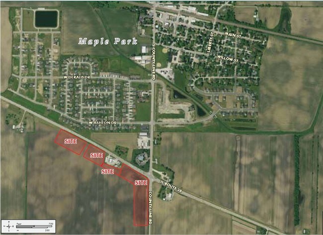
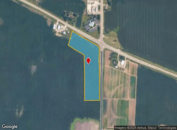
Property Record
State Rte 38, Maple Park, IL 60151
NEARBY LISTINGS FOR SALE OR LEASE
-
-
View all Maple Park listings for sale on LoopNet.com
Property Detail
State Rte 38
09-36-400-022
PT SE & NE - SEC 36 T40N R5E
Farms
DeKalb
X
Illinois
17089C0225J
10.27 AC
2023
Western East/West Corr
2024
Chicago
852403
Chicago-Naperville-Elgin, IL-IN-WI
DEMOGRAPHICS near State Rte 38
1 Mile
3 Mile
5 Mile
2024 Total Population
1,396
1,843
6,133
2029 Population
1,380
1,827
6,202
Pop Growth 2024-2029
(1.15%)
(0.87%)
+ 1.13%
Average Age
39
40
39
2024 Total Households
523
692
2,232
HH Growth 2024-2029
(1.34%)
(1.16%)
+ 0.90%
Median Household Inc
$110,759
$108,625
$94,342
Avg Household Size
2.70
2.70
2.70
2024 Avg HH Vehicles
2.00
2.00
2.00
Median Home Value
$236,158
$247,368
$226,178
Median Year Built
1984
1984
1992
Nearby Places
- Restaurants
- Banks
- Shops
- Fitness
- Groceries
PUBLIC TRANSPORTATION
COMMUTER RAIL
Elburn Station (Union Pacific West Line - Northeast Illinois Regional Commuter Railroad (Metra))
DRIVE
WALK
Distance
Elburn Station (Union Pacific West Line - Northeast Illinois Regional Commuter Railroad (Metra))
14 min
8.3 mi
Freight Ports
Port Milwaukee
DRIVE
WALK
Distance
Port Milwaukee
149 min
106.8 mi
Nearby Properties
Address
Land Use
TOTAL SIZE
Lot Size
Zoning
Address
Land Use
TOTAL SIZE
Lot Size
Zoning
6,520 SF
4.05 AC
A1
Address
Land Use
TOTAL SIZE
Lot Size
Zoning
37.26 AC
A1
Address
Land Use
TOTAL SIZE
Lot Size
Zoning
35,690 SF
0.19 AC
Address
Land Use
TOTAL SIZE
Lot Size
Zoning
2,816 SF
0.61 AC
Address
Land Use
TOTAL SIZE
Lot Size
Zoning
5,470 SF
1.92 AC
Address
Land Use
TOTAL SIZE
Lot Size
Zoning
3,396 SF
1.05 AC
A1
Address
Land Use
TOTAL SIZE
Lot Size
Zoning
16.49 AC
Address
Land Use
TOTAL SIZE
Lot Size
Zoning
11,882 SF
0.31 AC
Address
Land Use
TOTAL SIZE
Lot Size
Zoning
10,166 SF
1.25 AC
Address
Land Use
TOTAL SIZE
Lot Size
Zoning
1,776 SF
1.99 AC
Address
Land Use
TOTAL SIZE
Lot Size
Zoning
4,770 SF
2.01 AC
Address
Land Use
TOTAL SIZE
Lot Size
Zoning
176.58 AC
Address
Land Use
TOTAL SIZE
Lot Size
Zoning
9,000 SF
0.84 AC
Address
Land Use
TOTAL SIZE
Lot Size
Zoning
4,562 SF
0.23 AC
Address
Land Use
TOTAL SIZE
Lot Size
Zoning
155 AC
Address
Land Use
TOTAL SIZE
Lot Size
Zoning
156.65 AC
A1
Address
Land Use
TOTAL SIZE
Lot Size
Zoning
6,192 SF
0.12 AC
Address
Land Use
TOTAL SIZE
Lot Size
Zoning
149.37 AC
A1
Address
Land Use
TOTAL SIZE
Lot Size
Zoning
151.47 AC
A1
Address
Land Use
TOTAL SIZE
Lot Size
Zoning
4,080 SF
0.18 AC
Address
Land Use
TOTAL SIZE
Lot Size
Zoning
166.09 AC
Address
Land Use
TOTAL SIZE
Lot Size
Zoning
170.31 AC
Address
Land Use
TOTAL SIZE
Lot Size
Zoning
122.09 AC
Address
Land Use
TOTAL SIZE
Lot Size
Zoning
133.77 AC
Address
Land Use
TOTAL SIZE
Lot Size
Zoning
144.22 AC
Address
Land Use
TOTAL SIZE
Lot Size
Zoning
4,734 SF
0.23 AC
Address
Land Use
TOTAL SIZE
Lot Size
Zoning
1,865 SF
0.14 AC
Address
Land Use
TOTAL SIZE
Lot Size
Zoning
2.31 AC
Address
Land Use
TOTAL SIZE
Lot Size
Zoning
0.12 AC
Address
Land Use
TOTAL SIZE
Lot Size
Zoning
117 AC
A1
The World's #1 Commercial Real Estate Marketplace
Connect with us
© 2025 CoStar Group
The information above has been obtained from sources believed reliable. While we do not doubt its accuracy we have not verified it and make no guarantee, warranty or representation about it. It is your responsibility to independently confirm its accuracy and completeness. Any projections, opinions, assumptions, or estimates used are for example only and do not represent the current or future performance of the property. The value of this transaction to you depends on tax and other factors which should be evaluated by your tax, financial, and legal advisors. You and your advisors should conduct a careful, independent investigation of the property to determine to your satisfaction the suitability of the property for your needs.