Property Record
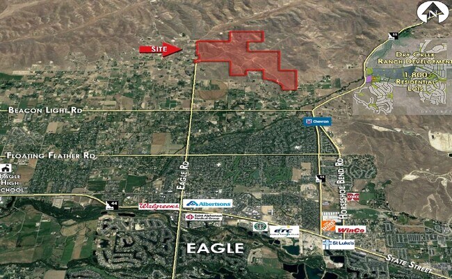
N Willow Creek Rd, Eagle, ID 83616
NEARBY LISTINGS FOR SALE OR LEASE
-
-
View all Eagle listings for sale on LoopNet.com
Property Detail
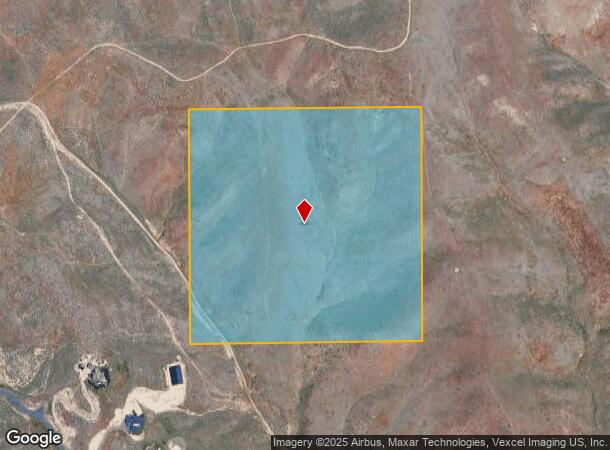
N Willow Creek Rd
S0227336200
SW4SW4 SEC 27 5N 1E
Pasture
Ada
X
Idaho
16001C0152H
40 AC
2024
North Ada County
2025
Boise City/Nampa
010232
Boise City, ID
DEMOGRAPHICS near N Willow Creek Rd
1 Mile
3 Mile
5 Mile
2024 Total Population
187
14,535
43,276
2029 Population
214
16,564
49,612
Pop Growth 2024-2029
+ 14.44%
+ 13.96%
+ 14.64%
Average Age
44
43
44
2024 Total Households
64
5,218
16,343
HH Growth 2024-2029
+ 14.06%
+ 14.24%
+ 14.91%
Median Household Inc
$92,187
$105,535
$96,882
Avg Household Size
2.80
2.80
2.60
2024 Avg HH Vehicles
2.00
2.00
2.00
Median Home Value
$799,999
$608,622
$617,780
Median Year Built
1992
1996
2003
Nearby Places
Map Layers
Map Styles
 Street
 Aerial
- Restaurants
- Banks
- Shops
- Fitness
- Groceries
PUBLIC TRANSPORTATION
AIRPORT
Boise Air Trml/Gowen Field
DRIVE
WALK
Distance
Boise Air Trml/Gowen Field
48 min
20.1 mi
Freight Ports
Port of Portland
DRIVE
WALK
Distance
Port of Portland
481 min
428.2 mi
SALE & LEASE HISTORY
LISTING DATE
SALE/LEASE

Jun 17, 2020
For Sale
Jul 25, 2018
For Sale
Nearby Properties
Address
Land Use
TOTAL SIZE
Lot Size
Zoning
Address
Land Use
TOTAL SIZE
Lot Size
Zoning
12.71 AC
C-3
Address
Land Use
TOTAL SIZE
Lot Size
Zoning
54,604 SF
2.72 AC
MU-DA
Address
Land Use
TOTAL SIZE
Lot Size
Zoning
41.08 AC
R-3-DA-P
Address
Land Use
TOTAL SIZE
Lot Size
Zoning
11.62 AC
R6
Address
Land Use
TOTAL SIZE
Lot Size
Zoning
86.81 AC
R-1-DA
Address
Land Use
TOTAL SIZE
Lot Size
Zoning
76.78 AC
R-1-DA
Address
Land Use
TOTAL SIZE
Lot Size
Zoning
59,292 SF
3.51 AC
MU-DA
Address
Land Use
TOTAL SIZE
Lot Size
Zoning
67.31 AC
R-1-DA
Address
Land Use
TOTAL SIZE
Lot Size
Zoning
57.62 AC
R-1-DA
Address
Land Use
TOTAL SIZE
Lot Size
Zoning
23.18 AC
R-2-DA-P
Address
Land Use
TOTAL SIZE
Lot Size
Zoning
39.75 AC
ZC-351
Address
Land Use
TOTAL SIZE
Lot Size
Zoning
39.74 AC
ZC-351
Address
Land Use
TOTAL SIZE
Lot Size
Zoning
38.75 AC
ZC-351
Address
Land Use
TOTAL SIZE
Lot Size
Zoning
38.56 AC
ZC-351
Address
Land Use
TOTAL SIZE
Lot Size
Zoning
48.08 AC
R-1-DA
Address
Land Use
TOTAL SIZE
Lot Size
Zoning
9,856 SF
10 AC
RR
Address
Land Use
TOTAL SIZE
Lot Size
Zoning
13,691 SF
136.87 AC
RR
Address
Land Use
TOTAL SIZE
Lot Size
Zoning
16.07 AC
MU-DA
Address
Land Use
TOTAL SIZE
Lot Size
Zoning
41.38 AC
R-1-DA
Address
Land Use
TOTAL SIZE
Lot Size
Zoning
14.78 AC
R-2-DA-P
Address
Land Use
TOTAL SIZE
Lot Size
Zoning
30.54 AC
R-1-DA
Address
Land Use
TOTAL SIZE
Lot Size
Zoning
13,674 SF
1.34 AC
MU-DA
Address
Land Use
TOTAL SIZE
Lot Size
Zoning
14,839 SF
4.68 AC
A-R-DA
Address
Land Use
TOTAL SIZE
Lot Size
Zoning
22.04 AC
MU-DA
Address
Land Use
TOTAL SIZE
Lot Size
Zoning
7 AC
MU-DA
Address
Land Use
TOTAL SIZE
Lot Size
Zoning
25.86 AC
R-1-DA
Address
Land Use
TOTAL SIZE
Lot Size
Zoning
17.69 AC
R-1-DA
Address
Land Use
TOTAL SIZE
Lot Size
Zoning
21.07 AC
R-1-DA
Address
Land Use
TOTAL SIZE
Lot Size
Zoning
16.27 AC
R-1-DA
Address
Land Use
TOTAL SIZE
Lot Size
Zoning
3,057 SF
0.57 AC
CBD
The World's #1 Commercial Real Estate Marketplace
Connect with us
© 2026 CoStar Group
The information above has been obtained from sources believed reliable. While we do not doubt its accuracy we have not verified it and make no guarantee, warranty or representation about it. It is your responsibility to independently confirm its accuracy and completeness. Any projections, opinions, assumptions, or estimates used are for example only and do not represent the current or future performance of the property. The value of this transaction to you depends on tax and other factors which should be evaluated by your tax, financial, and legal advisors. You and your advisors should conduct a careful, independent investigation of the property to determine to your satisfaction the suitability of the property for your needs.