Property Record
Terrell Rd, Carnesville, GA 30521

Property Detail
Terrell Rd
028-053
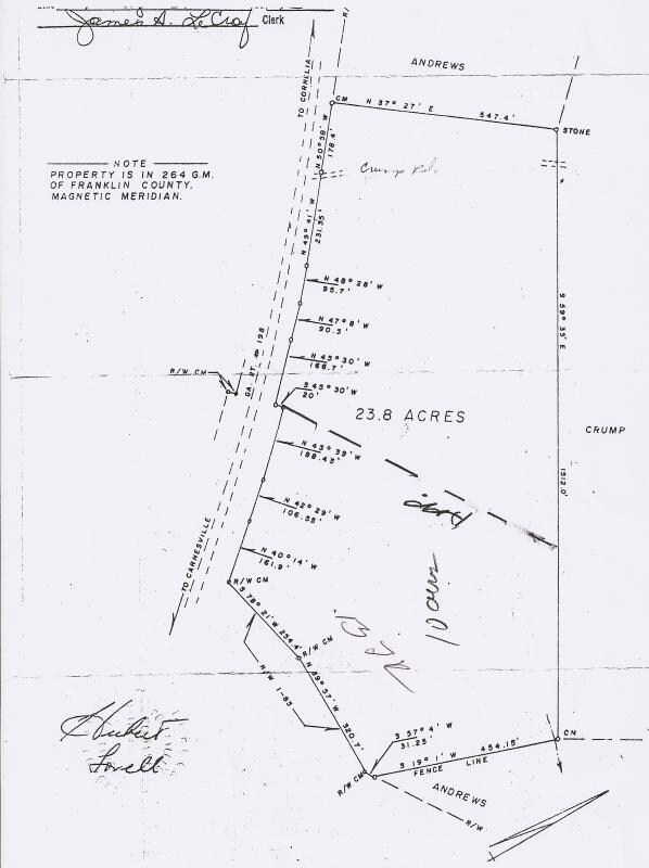
85.15 ACS CU HWY 198
Privatepreserveopenspacevacantlandforestlandconservation
FRANKLIN
UNZONED RU
Georgia
B and X Area of moderate flood hazard, usually the area between the limits of the 100-year and 500-year floods.
85.15 AC
2025
Georgia Northeast
2025
Other Market Areas
890201
NEARBY LISTINGS FOR SALE OR LEASE
DEMOGRAPHICS near Terrell Rd
1 mile
3 mile
5 mile
2025 Total Population
139
1,599
4,653
2030 Population
148
1,710
4,970
Pop Growth 2025-2030
+ 6.47%
+ 6.94%
+ 6.81%
Average Age
42
41
41
2025 Total Households
53
603
1,739
HH Growth 2025-2030
+ 7.55%
+ 6.80%
+ 6.67%
Median Household Inc
$53,333
$52,454
$54,588
Avg Household Size
2.50
2.50
2.60
2025 Avg HH Vehicles
2.00
3.00
3.00
Median Home Value
$433,333
$205,085
$198,287
Median Year Built
1988
1990
1990
Nearby Places
Map Layers
Map Styles
 Street
 Aerial
Layers
 Traffic
 Biking
Places
Listings with unknown addresses are not visible on the map
- Restaurants
- Banks
- Shops
- Fitness
- Groceries
Nearby Properties
Address
Land Use
TOTAL SIZE
Lot Size
Zoning
Address
Land Use
TOTAL SIZE
Lot Size
Zoning
178.03 AC
UNZONED RU
Address
Land Use
TOTAL SIZE
Lot Size
Zoning
17,840 SF
36.64 AC
COMMERCIAL
Address
Land Use
TOTAL SIZE
Lot Size
Zoning
13,497 SF
32.18 AC
COMMERCIAL
Address
Land Use
TOTAL SIZE
Lot Size
Zoning
28,376 SF
30.69 AC
COMMERCIAL
Address
Land Use
TOTAL SIZE
Lot Size
Zoning
8,526 SF
20 AC
UNZONED RU
Address
Land Use
TOTAL SIZE
Lot Size
Zoning
960 SF
11.46 AC
UNZONED RU
Address
Land Use
TOTAL SIZE
Lot Size
Zoning
97.13 AC
UNZONED RU
Address
Land Use
TOTAL SIZE
Lot Size
Zoning
303.64 AC
UNZONED RU
Address
Land Use
TOTAL SIZE
Lot Size
Zoning
1,064 SF
115.61 AC
UNZONED RU
Address
Land Use
TOTAL SIZE
Lot Size
Zoning
226.50 AC
UNZONED RU
Address
Land Use
TOTAL SIZE
Lot Size
Zoning
1,968 SF
207.35 AC
UNZONED RU
Address
Land Use
TOTAL SIZE
Lot Size
Zoning
209.08 AC
UNZONED RU
Address
Land Use
TOTAL SIZE
Lot Size
Zoning
201.93 AC
UNZONED RU
Address
Land Use
TOTAL SIZE
Lot Size
Zoning
5,632 SF
58.81 AC
COMMERCIAL
Address
Land Use
TOTAL SIZE
Lot Size
Zoning
32.82 AC
UNZONED RU
Address
Land Use
TOTAL SIZE
Lot Size
Zoning
156.90 AC
UNZONED RU
Address
Land Use
TOTAL SIZE
Lot Size
Zoning
2,176 SF
1.26 AC
UNZONED RU
Address
Land Use
TOTAL SIZE
Lot Size
Zoning
181.33 AC
UNZONED RU
Address
Land Use
TOTAL SIZE
Lot Size
Zoning
672 SF
5.48 AC
UNZONED RU
Address
Land Use
TOTAL SIZE
Lot Size
Zoning
4,000 SF
5.94 AC
Address
Land Use
TOTAL SIZE
Lot Size
Zoning
44,311 SF
20 AC
RESIDENTIA
Address
Land Use
TOTAL SIZE
Lot Size
Zoning
7,290 SF
2 AC
RESIDENTIA
Address
Land Use
TOTAL SIZE
Lot Size
Zoning
165.22 AC
UNZONED RU
Address
Land Use
TOTAL SIZE
Lot Size
Zoning
34.87 AC
UNZONED RU
Address
Land Use
TOTAL SIZE
Lot Size
Zoning
12,760 SF
RESIDENTIA
Address
Land Use
TOTAL SIZE
Lot Size
Zoning
143.22 AC
UNZONED RU
Address
Land Use
TOTAL SIZE
Lot Size
Zoning
7,324 SF
15 AC
COMMERCIAL
Address
Land Use
TOTAL SIZE
Lot Size
Zoning
137.50 AC
UNZONED RU
Address
Land Use
TOTAL SIZE
Lot Size
Zoning
20,211 SF
4.18 AC
COMMERCIAL
Address
Land Use
TOTAL SIZE
Lot Size
Zoning
41.70 AC
UNZONED RU
The World's #1 Commercial Real Estate Marketplace
Connect with us
© 2026 CoStar Group
The information above has been obtained from sources believed reliable. While we do not doubt its accuracy we have not verified it and make no guarantee, warranty or representation about it. It is your responsibility to independently confirm its accuracy and completeness. Any projections, opinions, assumptions, or estimates used are for example only and do not represent the current or future performance of the property. The value of this transaction to you depends on tax and other factors which should be evaluated by your tax, financial, and legal advisors. You and your advisors should conduct a careful, independent investigation of the property to determine to your satisfaction the suitability of the property for your needs.