Property Record
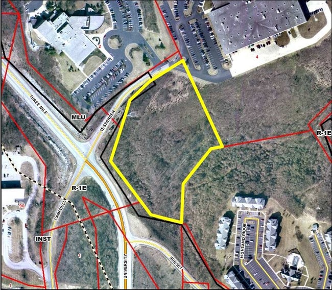
Tesseneer Dr, , KY

Property Detail
Tesseneer Dr
Cincinnati, OH-KY-IN
5.28 ACRES
999-99-34-177.00
CAMPBELL
Commercialnec
Kentucky
AE The base floodplain where base flood elevations are provided. AE Zones are now used on new format FIRMs instead of A1-A30 Zones.
5.28 AC
0
Outlying N Kentucky
2025
Cincinnati/Dayton
053301
NEARBY LISTINGS FOR SALE OR LEASE
DEMOGRAPHICS near Tesseneer Dr
1 mile
3 mile
5 mile
2025 Total Population
4,758
53,974
139,557
2030 Population
4,721
54,828
142,915
Pop Growth 2025-2030
(0.78%)
+ 1.58%
+ 2.41%
Average Age
39
40
40
2025 Total Households
1,857
23,262
61,800
HH Growth 2025-2030
(0.86%)
+ 1.55%
+ 2.60%
Median Household Inc
$86,105
$70,560
$77,632
Avg Household Size
2.10
2.20
2.10
2025 Avg HH Vehicles
2.00
2.00
2.00
Median Home Value
$237,077
$221,473
$260,929
Median Year Built
1981
1964
1959
Nearby Places
Map Layers
Map Styles
 Street
 Aerial
Transit
 Traffic
 Biking
Places
Listings with unknown addresses are not visible on the map
- Restaurants
- Banks
- Shops
- Fitness
- Groceries
PUBLIC TRANSPORTATION
COMMUTER RAIL
Cincinnati Union Terminal (Cardinal - Amtrak)
Drive
Walk
Distance
Cincinnati Union Terminal (Cardinal - Amtrak)
16 min
10.0 mi
AIRPORT
Cincinnati/Northern Kentucky International
Drive
Walk
Distance
Cincinnati/Northern Kentucky International
25 min
13.7 mi
Freight Ports
Port of Toledo
Drive
Walk
Distance
Port of Toledo
253 min
211.8 mi
Nearby Properties
Address
Land Use
TOTAL SIZE
Lot Size
Zoning
Address
Land Use
TOTAL SIZE
Lot Size
Zoning
560 SF
218.94 AC
Address
Land Use
TOTAL SIZE
Lot Size
Zoning
243,000 SF
11.30 AC
Address
Land Use
TOTAL SIZE
Lot Size
Zoning
0.95 AC
Address
Land Use
TOTAL SIZE
Lot Size
Zoning
411,750 SF
21.25 AC
Address
Land Use
TOTAL SIZE
Lot Size
Zoning
0.83 AC
Address
Land Use
TOTAL SIZE
Lot Size
Zoning
0.74 AC
Address
Land Use
TOTAL SIZE
Lot Size
Zoning
0.71 AC
Address
Land Use
TOTAL SIZE
Lot Size
Zoning
0.71 AC
Address
Land Use
TOTAL SIZE
Lot Size
Zoning
360,000 SF
Address
Land Use
TOTAL SIZE
Lot Size
Zoning
0.53 AC
Address
Land Use
TOTAL SIZE
Lot Size
Zoning
0.59 AC
Address
Land Use
TOTAL SIZE
Lot Size
Zoning
0.56 AC
Address
Land Use
TOTAL SIZE
Lot Size
Zoning
0.49 AC
Address
Land Use
TOTAL SIZE
Lot Size
Zoning
0.57 AC
Address
Land Use
TOTAL SIZE
Lot Size
Zoning
0.48 AC
Address
Land Use
TOTAL SIZE
Lot Size
Zoning
0.40 AC
Address
Land Use
TOTAL SIZE
Lot Size
Zoning
1,049,050 SF
8.60 AC
Address
Land Use
TOTAL SIZE
Lot Size
Zoning
0.33 AC
Address
Land Use
TOTAL SIZE
Lot Size
Zoning
20.49 AC
Address
Land Use
TOTAL SIZE
Lot Size
Zoning
21,600 SF
98.32 AC
Address
Land Use
TOTAL SIZE
Lot Size
Zoning
60,772 SF
0.78 AC
Address
Land Use
TOTAL SIZE
Lot Size
Zoning
Address
Land Use
TOTAL SIZE
Lot Size
Zoning
20.01 AC
Address
Land Use
TOTAL SIZE
Lot Size
Zoning
1,800 SF
10.18 AC
Address
Land Use
TOTAL SIZE
Lot Size
Zoning
16.50 AC
Address
Land Use
TOTAL SIZE
Lot Size
Zoning
15,570 SF
21.35 AC
Address
Land Use
TOTAL SIZE
Lot Size
Zoning
25.96 AC
Address
Land Use
TOTAL SIZE
Lot Size
Zoning
46,600 SF
52.47 AC
Address
Land Use
TOTAL SIZE
Lot Size
Zoning
18,288 SF
41.21 AC
Address
Land Use
TOTAL SIZE
Lot Size
Zoning
2,837 SF
3.77 AC
The World's #1 Commercial Real Estate Marketplace
Connect with us
© 2026 CoStar Group
The information above has been obtained from sources believed reliable. While we do not doubt its accuracy we have not verified it and make no guarantee, warranty or representation about it. It is your responsibility to independently confirm its accuracy and completeness. Any projections, opinions, assumptions, or estimates used are for example only and do not represent the current or future performance of the property. The value of this transaction to you depends on tax and other factors which should be evaluated by your tax, financial, and legal advisors. You and your advisors should conduct a careful, independent investigation of the property to determine to your satisfaction the suitability of the property for your needs.