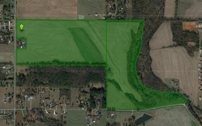
Property Record
Thach Rd, Athens, AL 35613
Property Detail
Thach Rd
Huntsville, AL
N/2 SW/4 LESS R/W LESS A PARCEL COM INT N LN NW/4 SW/4 & ELYR/W ST HWY 251 TH S 570 ALGSD R/W TO POB CONT S 290 (276)ALG SD R
01-07-26-0-000-008.000
LIMESTONE
Agriculturalland
Alabama
A Areas with a 1% annual chance of flooding and a 26% chance of flooding over the life of a 30-year mortgage.
72 AC
2025
Outlying Limestone County
2025
Huntsville
010405
NEARBY LISTINGS FOR SALE OR LEASE
-
-
View all Athens listings for sale on LoopNet.com
DEMOGRAPHICS near Thach Rd
1 mile
3 mile
5 mile
2024 Total Population
1,116
5,017
16,328
2029 Population
1,301
5,827
18,838
Pop Growth 2024-2029
+ 16.58%
+ 16.15%
+ 15.37%
Average Age
40
41
41
2024 Total Households
421
1,934
6,266
HH Growth 2024-2029
+ 16.86%
+ 16.65%
+ 15.96%
Median Household Inc
$60,735
$59,294
$59,440
Avg Household Size
2.60
2.60
2.50
2024 Avg HH Vehicles
2.00
2.00
2.00
Median Home Value
$214,583
$201,659
$192,716
Median Year Built
1996
1995
1992
Nearby Places
Map Layers
Map Styles
 Street
 Aerial
Transit
 Traffic
 Biking
Places
Listings with unknown addresses are not visible on the map
- Restaurants
- Banks
- Shops
- Fitness
- Groceries
PUBLIC TRANSPORTATION
AIRPORT
Huntsville International-Carl T Jones Field
Drive
Walk
Distance
Huntsville International-Carl T Jones Field
43 min
24.6 mi
Freight Ports
Port of Mobile
Drive
Walk
Distance
Port of Mobile
397 min
362.1 mi
SALE & LEASE HISTORY
LISTING DATE
SALE/LEASE

Apr 01, 2024
For Sale
Nearby Properties
Address
Land Use
TOTAL SIZE
Lot Size
Zoning
Address
Land Use
TOTAL SIZE
Lot Size
Zoning
92,600 SF
19.39 AC
Address
Land Use
TOTAL SIZE
Lot Size
Zoning
3.06 AC
Address
Land Use
TOTAL SIZE
Lot Size
Zoning
36,822 SF
1.37 AC
Address
Land Use
TOTAL SIZE
Lot Size
Zoning
3,000 SF
5.60 AC
Address
Land Use
TOTAL SIZE
Lot Size
Zoning
43,060 SF
7 AC
Address
Land Use
TOTAL SIZE
Lot Size
Zoning
16,536 SF
1.63 AC
Address
Land Use
TOTAL SIZE
Lot Size
Zoning
9,100 SF
2.42 AC
Address
Land Use
TOTAL SIZE
Lot Size
Zoning
11,154 SF
3.70 AC
Address
Land Use
TOTAL SIZE
Lot Size
Zoning
Address
Land Use
TOTAL SIZE
Lot Size
Zoning
9,217 SF
0.88 AC
Address
Land Use
TOTAL SIZE
Lot Size
Zoning
2,224 SF
3.60 AC
Address
Land Use
TOTAL SIZE
Lot Size
Zoning
15,280 SF
0.67 AC
Address
Land Use
TOTAL SIZE
Lot Size
Zoning
2,560 SF
50 AC
Address
Land Use
TOTAL SIZE
Lot Size
Zoning
6,064 SF
1.90 AC
Address
Land Use
TOTAL SIZE
Lot Size
Zoning
9,000 SF
1 AC
Address
Land Use
TOTAL SIZE
Lot Size
Zoning
5,504 SF
2.09 AC
Address
Land Use
TOTAL SIZE
Lot Size
Zoning
1,800 SF
5.44 AC
Address
Land Use
TOTAL SIZE
Lot Size
Zoning
0.80 AC
Address
Land Use
TOTAL SIZE
Lot Size
Zoning
4,000 SF
3.80 AC
Address
Land Use
TOTAL SIZE
Lot Size
Zoning
6,243 SF
1 AC
Address
Land Use
TOTAL SIZE
Lot Size
Zoning
2,320 SF
9 AC
Address
Land Use
TOTAL SIZE
Lot Size
Zoning
57 AC
Address
Land Use
TOTAL SIZE
Lot Size
Zoning
4,016 SF
6.24 AC
Address
Land Use
TOTAL SIZE
Lot Size
Zoning
4,182 SF
0.86 AC
Address
Land Use
TOTAL SIZE
Lot Size
Zoning
2,442 SF
3 AC
Address
Land Use
TOTAL SIZE
Lot Size
Zoning
Address
Land Use
TOTAL SIZE
Lot Size
Zoning
4,702 SF
0.90 AC
Address
Land Use
TOTAL SIZE
Lot Size
Zoning
Address
Land Use
TOTAL SIZE
Lot Size
Zoning
2,472 SF
3 AC
Address
Land Use
TOTAL SIZE
Lot Size
Zoning
3,828 SF
1 AC
The World's #1 Commercial Real Estate Marketplace
Connect with us
© 2026 CoStar Group
The information above has been obtained from sources believed reliable. While we do not doubt its accuracy we have not verified it and make no guarantee, warranty or representation about it. It is your responsibility to independently confirm its accuracy and completeness. Any projections, opinions, assumptions, or estimates used are for example only and do not represent the current or future performance of the property. The value of this transaction to you depends on tax and other factors which should be evaluated by your tax, financial, and legal advisors. You and your advisors should conduct a careful, independent investigation of the property to determine to your satisfaction the suitability of the property for your needs.