Property Record
9280 Tharp Rd, Seaford, DE 19973

This Property Is For Sale
Property Detail
9280 Tharp Rd
331-06.00-9.03
S/RT 534 765'E/RT 13
Miscresidentialimprovement
SUSSEX
TN
Delaware
B and X Area of moderate flood hazard, usually the area between the limits of the 100-year and 500-year floods.
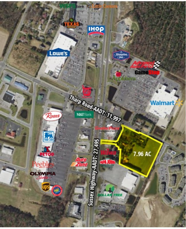
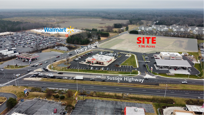
7.96 AC
2025
Sussex County
2025
Philadelphia
050407
Seaford, DE
NEARBY LISTINGS FOR SALE OR LEASE
-
-
-
No Photo
-
-
View all Seaford listings for sale on LoopNet.com
DEMOGRAPHICS near 9280 Tharp Rd
1 mile
3 mile
5 mile
2025 Total Population
2,760
17,813
27,408
2030 Population
2,998
19,025
29,283
Pop Growth 2025-2030
+ 8.62%
+ 6.80%
+ 6.84%
Average Age
41
41
42
2025 Total Households
1,066
6,504
10,098
HH Growth 2025-2030
+ 8.16%
+ 6.21%
+ 6.36%
Median Household Inc
$49,536
$58,788
$58,471
Avg Household Size
2.50
2.60
2.60
2025 Avg HH Vehicles
2.00
2.00
2.00
Median Home Value
$307,936
$270,809
$274,297
Median Year Built
1994
1988
1992
Nearby Places
Map Layers
Map Styles
 Street
 Aerial
Layers
 Traffic
 Biking
Places
Listings with unknown addresses are not visible on the map
- Restaurants
- Banks
- Shops
- Fitness
- Groceries
PUBLIC TRANSPORTATION
AIRPORT
Salisbury-Ocean City Wicomico Regional
Drive
Walk
Distance
Salisbury-Ocean City Wicomico Regional
42 min
27.0 mi
Freight Ports
Port of Baltimore
Drive
Walk
Distance
Port of Baltimore
127 min
85.1 mi
Nearby Properties
Address
Land Use
TOTAL SIZE
Lot Size
Zoning
Address
Land Use
TOTAL SIZE
Lot Size
Zoning
523.79 AC
HI-1
Address
Land Use
TOTAL SIZE
Lot Size
Zoning
45.20 AC
TN
Address
Land Use
TOTAL SIZE
Lot Size
Zoning
36.36 AC
TN
Address
Land Use
TOTAL SIZE
Lot Size
Zoning
21.44 AC
TN
Address
Land Use
TOTAL SIZE
Lot Size
Zoning
15.33 AC
TN
Address
Land Use
TOTAL SIZE
Lot Size
Zoning
1.15 AC
TN
Address
Land Use
TOTAL SIZE
Lot Size
Zoning
26.21 AC
TN
Address
Land Use
TOTAL SIZE
Lot Size
Zoning
31.75 AC
TN
Address
Land Use
TOTAL SIZE
Lot Size
Zoning
22.36 AC
TN
Address
Land Use
TOTAL SIZE
Lot Size
Zoning
55.47 AC
TN
Address
Land Use
TOTAL SIZE
Lot Size
Zoning
42.15 AC
HI-1
Address
Land Use
TOTAL SIZE
Lot Size
Zoning
18.62 AC
TN
Address
Land Use
TOTAL SIZE
Lot Size
Zoning
261.47 AC
TN
Address
Land Use
TOTAL SIZE
Lot Size
Zoning
11.53 AC
TN
Address
Land Use
TOTAL SIZE
Lot Size
Zoning
13.27 AC
TN
Address
Land Use
TOTAL SIZE
Lot Size
Zoning
3.07 AC
TN
Address
Land Use
TOTAL SIZE
Lot Size
Zoning
19.52 AC
TN
Address
Land Use
TOTAL SIZE
Lot Size
Zoning
6.45 AC
TN
Address
Land Use
TOTAL SIZE
Lot Size
Zoning
13.39 AC
TN
Address
Land Use
TOTAL SIZE
Lot Size
Zoning
1.40 AC
TN
Address
Land Use
TOTAL SIZE
Lot Size
Zoning
7.77 AC
TN
Address
Land Use
TOTAL SIZE
Lot Size
Zoning
9.92 AC
TN
Address
Land Use
TOTAL SIZE
Lot Size
Zoning
4.41 AC
TN
Address
Land Use
TOTAL SIZE
Lot Size
Zoning
18.43 AC
TN
Address
Land Use
TOTAL SIZE
Lot Size
Zoning
3.70 AC
TN
Address
Land Use
TOTAL SIZE
Lot Size
Zoning
5.38 AC
TN
Address
Land Use
TOTAL SIZE
Lot Size
Zoning
4,449 SF
104.48 AC
AR1
Address
Land Use
TOTAL SIZE
Lot Size
Zoning
2.33 AC
TN
Address
Land Use
TOTAL SIZE
Lot Size
Zoning
10 AC
TN
The World's #1 Commercial Real Estate Marketplace
Connect with us
© 2026 CoStar Group
The information above has been obtained from sources believed reliable. While we do not doubt its accuracy we have not verified it and make no guarantee, warranty or representation about it. It is your responsibility to independently confirm its accuracy and completeness. Any projections, opinions, assumptions, or estimates used are for example only and do not represent the current or future performance of the property. The value of this transaction to you depends on tax and other factors which should be evaluated by your tax, financial, and legal advisors. You and your advisors should conduct a careful, independent investigation of the property to determine to your satisfaction the suitability of the property for your needs.