Property Record
Theodore Ln, Itasca, IL 60143
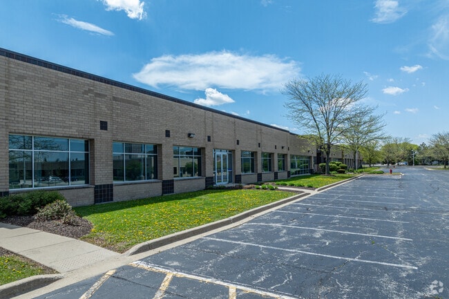

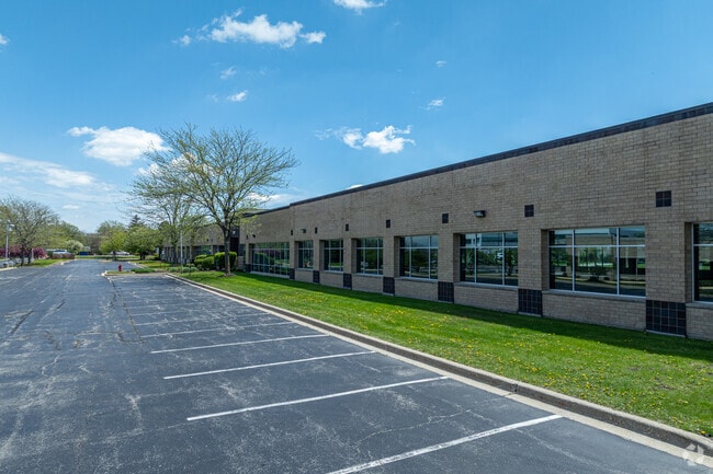
Property Detail
Theodore Ln
03-05-403-009
ARLINGTON THORNDALE RESUB ALL
Commercialnec
DUPAGE
C
Illinois
B and X Area of moderate flood hazard, usually the area between the limits of the 100-year and 500-year floods.
3
2024
3.07 AC
2024
North DuPage
840201
Chicago
36,126 SF
Chicago-Naperville-Elgin, IL-IN
NEARBY LISTINGS FOR SALE OR LEASE
DEMOGRAPHICS near Theodore Ln
1 mile
3 mile
5 mile
2025 Total Population
6,313
69,526
209,991
2030 Population
6,353
69,777
211,207
Pop Growth 2025-2030
+ 0.63%
+ 0.36%
+ 0.58%
Average Age
42
43
41
2025 Total Households
2,462
26,819
79,420
HH Growth 2025-2030
+ 0.53%
+ 0.20%
+ 0.48%
Median Household Inc
$121,196
$97,456
$89,376
Avg Household Size
2.50
2.50
2.60
2025 Avg HH Vehicles
2.00
2.00
2.00
Median Home Value
$380,578
$344,883
$332,526
Median Year Built
1977
1973
1975
Nearby Places
Map Layers
Map Styles
 Street
 Aerial
Transit
 Traffic
 Biking
Places
Listings with unknown addresses are not visible on the map
- Restaurants
- Banks
- Shops
- Fitness
- Groceries
PUBLIC TRANSPORTATION
COMMUTER RAIL
Itasca Station (Milwaukee District West Line - Northeast Illinois Regional Commuter Railroad (Metra))
Drive
Walk
Distance
Itasca Station (Milwaukee District West Line - Northeast Illinois Regional Commuter Railroad (Metra))
4 min
1.2 mi
Wood Dale Station (Milwaukee District West Line - Northeast Illinois Regional Commuter Railroad (Metra))
Drive
Walk
Distance
Wood Dale Station (Milwaukee District West Line - Northeast Illinois Regional Commuter Railroad (Metra))
6 min
3.0 mi
AIRPORT
Chicago O'Hare International
Drive
Walk
Distance
Chicago O'Hare International
20 min
11.8 mi
Chicago Midway International
Drive
Walk
Distance
Chicago Midway International
39 min
23.5 mi
SALE & LEASE HISTORY
LISTING DATE
SALE/LEASE

May 06, 2020
For Sale
Mar 25, 2019
For Lease
Nearby Properties
Address
Land Use
TOTAL SIZE
Lot Size
Zoning
Address
Land Use
TOTAL SIZE
Lot Size
Zoning
Address
Land Use
TOTAL SIZE
Lot Size
Zoning
310,751 SF
15.04 AC
Address
Land Use
TOTAL SIZE
Lot Size
Zoning
333,258 SF
9.48 AC
Address
Land Use
TOTAL SIZE
Lot Size
Zoning
189,290 SF
9.51 AC
Address
Land Use
TOTAL SIZE
Lot Size
Zoning
410,822 SF
14.26 AC
Address
Land Use
TOTAL SIZE
Lot Size
Zoning
208,000 SF
10.35 AC
Address
Land Use
TOTAL SIZE
Lot Size
Zoning
18.91 AC
Address
Land Use
TOTAL SIZE
Lot Size
Zoning
Address
Land Use
TOTAL SIZE
Lot Size
Zoning
179,780 SF
8.12 AC
I
Address
Land Use
TOTAL SIZE
Lot Size
Zoning
457,762 SF
23 AC
M
Address
Land Use
TOTAL SIZE
Lot Size
Zoning
58,373 SF
11.22 AC
Address
Land Use
TOTAL SIZE
Lot Size
Zoning
17.67 AC
Address
Land Use
TOTAL SIZE
Lot Size
Zoning
74,664 SF
3.19 AC
Address
Land Use
TOTAL SIZE
Lot Size
Zoning
Address
Land Use
TOTAL SIZE
Lot Size
Zoning
17.73 AC
Address
Land Use
TOTAL SIZE
Lot Size
Zoning
14.76 AC
Address
Land Use
TOTAL SIZE
Lot Size
Zoning
525,422 SF
8.45 AC
C
Address
Land Use
TOTAL SIZE
Lot Size
Zoning
15.32 AC
Address
Land Use
TOTAL SIZE
Lot Size
Zoning
487,027 SF
8.36 AC
C
Address
Land Use
TOTAL SIZE
Lot Size
Zoning
15.29 AC
Address
Land Use
TOTAL SIZE
Lot Size
Zoning
450,614 SF
17.97 AC
C
Address
Land Use
TOTAL SIZE
Lot Size
Zoning
469,492 SF
14.87 AC
I
Address
Land Use
TOTAL SIZE
Lot Size
Zoning
24.82 AC
Address
Land Use
TOTAL SIZE
Lot Size
Zoning
24.82 AC
Address
Land Use
TOTAL SIZE
Lot Size
Zoning
Address
Land Use
TOTAL SIZE
Lot Size
Zoning
24.82 AC
Address
Land Use
TOTAL SIZE
Lot Size
Zoning
489,153 SF
18.90 AC
I
Address
Land Use
TOTAL SIZE
Lot Size
Zoning
441,232 SF
34.52 AC
I
Address
Land Use
TOTAL SIZE
Lot Size
Zoning
338,816 SF
16.84 AC
I
Address
Land Use
TOTAL SIZE
Lot Size
Zoning
288,000 SF
11.05 AC
C
The World's #1 Commercial Real Estate Marketplace
Connect with us
© 2026 CoStar Group
The information above has been obtained from sources believed reliable. While we do not doubt its accuracy we have not verified it and make no guarantee, warranty or representation about it. It is your responsibility to independently confirm its accuracy and completeness. Any projections, opinions, assumptions, or estimates used are for example only and do not represent the current or future performance of the property. The value of this transaction to you depends on tax and other factors which should be evaluated by your tax, financial, and legal advisors. You and your advisors should conduct a careful, independent investigation of the property to determine to your satisfaction the suitability of the property for your needs.