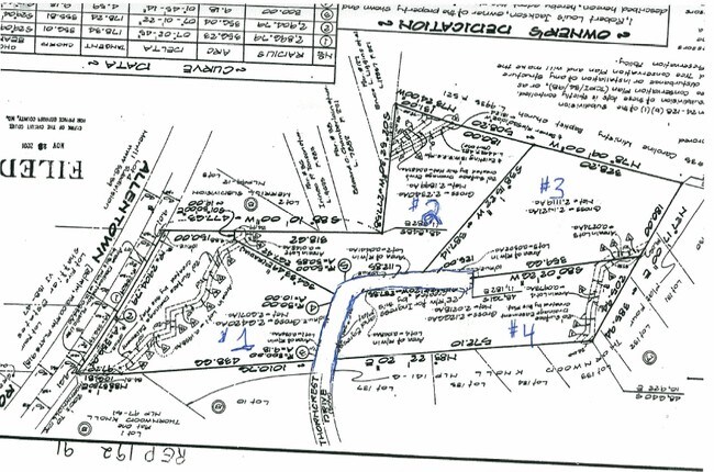
Property Record
9706 Thorncrest Dr, Fort Washington, MD 20744
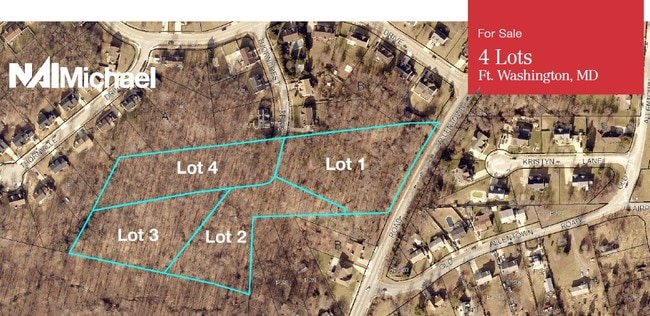

This Property Is For Sale
NEARBY LISTINGS FOR SALE OR LEASE
-
-
-
-
-
-
-
No Photo
-
View all Fort Washington listings for sale on LoopNet.com
Property Detail
9706 Thorncrest Dr
Washington-Arlington-Alexandria, DC-VA-MD-WV
Prince George's
05-3414679
Maryland
Residentialnec
2.64 AC
X
NatHbr/OxnHill/FtWash
24033C0240E
Washington, DC
DEMOGRAPHICS near 9706 Thorncrest Dr
1 Mile
3 Mile
5 Mile
2024 Total Population
5,561
48,211
148,236
2029 Population
5,396
46,967
144,255
Pop Growth 2024-2029
(2.97%)
(2.58%)
(2.69%)
Average Age
44
44
42
2024 Total Households
1,856
17,277
54,745
HH Growth 2024-2029
(3.02%)
(2.66%)
(2.75%)
Median Household Inc
$131,851
$112,549
$102,296
Avg Household Size
2.90
2.70
2.60
2024 Avg HH Vehicles
2.00
2.00
2.00
Median Home Value
$421,171
$396,645
$384,814
Median Year Built
1982
1979
1975
Nearby Places
Map Layers
Map Styles
 Street
 Aerial
- Restaurants
- Banks
- Shops
- Fitness
- Groceries
PUBLIC TRANSPORTATION
COMMUTER RAIL
1 (Fredericksburg Line - Virginia Railway Express, Manassas Line - Virginia Railway Express)
DRIVE
WALK
Distance
1 (Fredericksburg Line - Virginia Railway Express, Manassas Line - Virginia Railway Express)
17 min
9.5 mi
Alexandria (Fredericksburg Line - Virginia Railway Express, Manassas Line - Virginia Railway Express)
DRIVE
WALK
Distance
Alexandria (Fredericksburg Line - Virginia Railway Express, Manassas Line - Virginia Railway Express)
17 min
9.6 mi
AIRPORT
Ronald Reagan Washington Ntl
DRIVE
WALK
Distance
Ronald Reagan Washington Ntl
28 min
13.5 mi
Washington Dulles International
DRIVE
WALK
Distance
Washington Dulles International
62 min
40.7 mi
Freight Ports
Port of Baltimore
DRIVE
WALK
Distance
Port of Baltimore
70 min
46.4 mi
Nearby Properties
Address
Land Use
TOTAL SIZE
Lot Size
Zoning
Address
Land Use
TOTAL SIZE
Lot Size
Zoning
380 SF
17.44 AC
RMF20
Address
Land Use
TOTAL SIZE
Lot Size
Zoning
235,000 SF
23.52 AC
ROS
Address
Land Use
TOTAL SIZE
Lot Size
Zoning
116 SF
10.37 AC
RMF20
Address
Land Use
TOTAL SIZE
Lot Size
Zoning
300,005 SF
9.94 AC
RR
Address
Land Use
TOTAL SIZE
Lot Size
Zoning
11.65 AC
RMF20
Address
Land Use
TOTAL SIZE
Lot Size
Zoning
434,910 SF
0.46 AC
RR
Address
Land Use
TOTAL SIZE
Lot Size
Zoning
8.02 AC
RMF20
Address
Land Use
TOTAL SIZE
Lot Size
Zoning
1,217 SF
8.94 AC
RMF20
Address
Land Use
TOTAL SIZE
Lot Size
Zoning
89,089 SF
4.78 AC
CGO
Address
Land Use
TOTAL SIZE
Lot Size
Zoning
78,713 SF
12.16 AC
RR
Address
Land Use
TOTAL SIZE
Lot Size
Zoning
120,986 SF
16.42 AC
RR
Address
Land Use
TOTAL SIZE
Lot Size
Zoning
126,798 SF
105.85 AC
RR
Address
Land Use
TOTAL SIZE
Lot Size
Zoning
86,600 SF
1.68 AC
CS
Address
Land Use
TOTAL SIZE
Lot Size
Zoning
200 SF
13.95 AC
RR
Address
Land Use
TOTAL SIZE
Lot Size
Zoning
72,550 SF
15.97 AC
RR
Address
Land Use
TOTAL SIZE
Lot Size
Zoning
68,960 SF
7.03 AC
CGO
Address
Land Use
TOTAL SIZE
Lot Size
Zoning
42,264 SF
3.77 AC
CGO
Address
Land Use
TOTAL SIZE
Lot Size
Zoning
87,622 SF
5.74 AC
RR
Address
Land Use
TOTAL SIZE
Lot Size
Zoning
15,200 SF
2.01 AC
CGO
Address
Land Use
TOTAL SIZE
Lot Size
Zoning
43,543 SF
4.15 AC
CS
Address
Land Use
TOTAL SIZE
Lot Size
Zoning
192,850 SF
28.85 AC
RR
Address
Land Use
TOTAL SIZE
Lot Size
Zoning
59,816 SF
6.86 AC
CGO
Address
Land Use
TOTAL SIZE
Lot Size
Zoning
26,946 SF
19.49 AC
LCD
Address
Land Use
TOTAL SIZE
Lot Size
Zoning
86,507 SF
5.19 AC
RE
Address
Land Use
TOTAL SIZE
Lot Size
Zoning
11,094 SF
2.16 AC
CGO
Address
Land Use
TOTAL SIZE
Lot Size
Zoning
96.22 AC
ROS
Address
Land Use
TOTAL SIZE
Lot Size
Zoning
112,576 SF
10.19 AC
RSF95
Address
Land Use
TOTAL SIZE
Lot Size
Zoning
128,624 SF
21.29 AC
RSF95
Address
Land Use
TOTAL SIZE
Lot Size
Zoning
97,174 SF
5.49 AC
RE
Address
Land Use
TOTAL SIZE
Lot Size
Zoning
17,618 SF
12.32 AC
IE
The World's #1 Commercial Real Estate Marketplace
Connect with us
© 2025 CoStar Group
The information above has been obtained from sources believed reliable. While we do not doubt its accuracy we have not verified it and make no guarantee, warranty or representation about it. It is your responsibility to independently confirm its accuracy and completeness. Any projections, opinions, assumptions, or estimates used are for example only and do not represent the current or future performance of the property. The value of this transaction to you depends on tax and other factors which should be evaluated by your tax, financial, and legal advisors. You and your advisors should conduct a careful, independent investigation of the property to determine to your satisfaction the suitability of the property for your needs.