Property Record
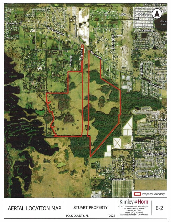
Thornhill Rd, Winter Haven, FL 33880
Save to a Folder
{{folder.Name}}
{{folder.ListingIds.length}} Properties
{{folder.ListingIds.length}} Property
Create a New Folder
Property Detail
Thornhill Rd
25-29-03-000000-022120
BEG NE COR OF SEC RUN S 663.12 FT N 45 DEG 25 MIN 26 SEC W 939.25 FT E 664.02 FT TO POB LESS THAT PART LYING WITHIN SWFWMD PCL 20-503-123-P LAKE HANCOCK OUTFALL AS DESC IN STIPULATED AMENDED ORDER OF TAKING CASE#2010-CA-009204 REC IN OR 8487-2191
Pasture
POLK
RC
Florida
AE The base floodplain where base flood elevations are provided. AE Zones are now used on new format FIRMs instead of A1-A30 Zones.
83.11 AC
2025
Polk County
2025
Tampa/St Petersburg
013802
Lakeland-Winter Haven, FL
2,500 SF
NEARBY LISTINGS FOR SALE OR LEASE
DEMOGRAPHICS near Thornhill Rd
1 mile
3 mile
5 mile
2025 Total Population
1,719
19,990
57,920
2030 Population
1,985
22,804
66,260
Pop Growth 2025-2030
+ 15.47%
+ 14.08%
+ 14.40%
Average Age
42
41
39
2025 Total Households
649
7,353
21,519
HH Growth 2025-2030
+ 15.87%
+ 14.35%
+ 14.68%
Median Household Inc
$72,358
$73,307
$63,814
Avg Household Size
2.60
2.70
2.60
2025 Avg HH Vehicles
2.00
2.00
2.00
Median Home Value
$304,687
$291,935
$266,275
Median Year Built
1998
1989
1984
Nearby Places
Map Layers
Map Styles
 Street
 Aerial
Layers
 Traffic
 Biking
Places
Listings with unknown addresses are not visible on the map
- Restaurants
- Banks
- Shops
- Fitness
- Groceries
PUBLIC TRANSPORTATION
COMMUTER RAIL
Winter Haven (Silver Meteor - Amtrak, Silver Star - Amtrak)
Drive
Walk
Distance
Winter Haven (Silver Meteor - Amtrak, Silver Star - Amtrak)
11 min
5.4 mi
Freight Ports
Port of Tampa Bay
Drive
Walk
Distance
Port of Tampa Bay
61 min
46.0 mi
Nearby Properties
Address
Land Use
TOTAL SIZE
Lot Size
Zoning
Address
Land Use
TOTAL SIZE
Lot Size
Zoning
202,567 SF
189.02 AC
RE1
Address
Land Use
TOTAL SIZE
Lot Size
Zoning
215,942 SF
43.90 AC
Address
Land Use
TOTAL SIZE
Lot Size
Zoning
110,108 SF
10 AC
Address
Land Use
TOTAL SIZE
Lot Size
Zoning
941,344 SF
205.10 AC
Address
Land Use
TOTAL SIZE
Lot Size
Zoning
53,219 SF
49.88 AC
Address
Land Use
TOTAL SIZE
Lot Size
Zoning
45,571 SF
4.73 AC
Address
Land Use
TOTAL SIZE
Lot Size
Zoning
78,616 SF
21.57 AC
Address
Land Use
TOTAL SIZE
Lot Size
Zoning
88,192 SF
18.31 AC
Address
Land Use
TOTAL SIZE
Lot Size
Zoning
50,869 SF
5.98 AC
C3
Address
Land Use
TOTAL SIZE
Lot Size
Zoning
48,160 SF
73.79 AC
XX
Address
Land Use
TOTAL SIZE
Lot Size
Zoning
13,973 SF
7.50 AC
Address
Land Use
TOTAL SIZE
Lot Size
Zoning
250,101 SF
24.41 AC
RC
Address
Land Use
TOTAL SIZE
Lot Size
Zoning
14,500 SF
2.52 AC
C3
Address
Land Use
TOTAL SIZE
Lot Size
Zoning
475.05 AC
Address
Land Use
TOTAL SIZE
Lot Size
Zoning
30,055 SF
1.73 AC
Address
Land Use
TOTAL SIZE
Lot Size
Zoning
18,900 SF
3.95 AC
Address
Land Use
TOTAL SIZE
Lot Size
Zoning
18,224 SF
14.15 AC
RC
Address
Land Use
TOTAL SIZE
Lot Size
Zoning
37,889 SF
4.96 AC
XX
Address
Land Use
TOTAL SIZE
Lot Size
Zoning
5,828 SF
1.17 AC
C3
Address
Land Use
TOTAL SIZE
Lot Size
Zoning
2,304 SF
355.92 AC
Address
Land Use
TOTAL SIZE
Lot Size
Zoning
13,600 SF
2 AC
XX
Address
Land Use
TOTAL SIZE
Lot Size
Zoning
5,167 SF
11.89 AC
Address
Land Use
TOTAL SIZE
Lot Size
Zoning
9,724 SF
1.15 AC
C3
Address
Land Use
TOTAL SIZE
Lot Size
Zoning
6,276 SF
3.09 AC
C4
Address
Land Use
TOTAL SIZE
Lot Size
Zoning
9,000 SF
2.56 AC
CG
Address
Land Use
TOTAL SIZE
Lot Size
Zoning
4,800 SF
0.96 AC
C3
Address
Land Use
TOTAL SIZE
Lot Size
Zoning
5,340 SF
3.66 AC
CG
Address
Land Use
TOTAL SIZE
Lot Size
Zoning
13,100 SF
4.58 AC
Address
Land Use
TOTAL SIZE
Lot Size
Zoning
12,850 SF
1.72 AC
RE1
Address
Land Use
TOTAL SIZE
Lot Size
Zoning
7,553 SF
1.69 AC
XX
The World's #1 Commercial Real Estate Marketplace
Connect with us
© 2026 CoStar Group
The information above has been obtained from sources believed reliable. While we do not doubt its accuracy we have not verified it and make no guarantee, warranty or representation about it. It is your responsibility to independently confirm its accuracy and completeness. Any projections, opinions, assumptions, or estimates used are for example only and do not represent the current or future performance of the property. The value of this transaction to you depends on tax and other factors which should be evaluated by your tax, financial, and legal advisors. You and your advisors should conduct a careful, independent investigation of the property to determine to your satisfaction the suitability of the property for your needs.