Property Record
Thunderbird Rd, Apple Valley, CA 92307

Property Detail
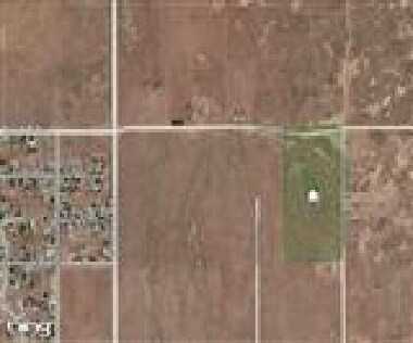
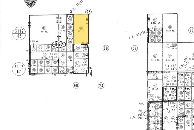
Thunderbird Rd
Riverside-San Bernardino-Ontario, CA
E 1/2 NE 1/4 NW 1/4 SEC 14 TP 5N R 3W
0437-062-06
SAN BERNARDINO
Vacantlandnec
California
A Areas with a 1% annual chance of flooding and a 26% chance of flooding over the life of a 30-year mortgage.
20 AC
2025
Mojave River Valley
2025
Inland Empire (California)
009714
NEARBY LISTINGS FOR SALE OR LEASE
DEMOGRAPHICS near Thunderbird Rd
1 mile
3 mile
5 mile
2025 Total Population
1,387
21,443
58,535
2030 Population
1,406
21,730
59,304
Pop Growth 2025-2030
+ 1.37%
+ 1.34%
+ 1.31%
Average Age
37
38
38
2025 Total Households
437
6,923
18,962
HH Growth 2025-2030
+ 1.37%
+ 1.34%
+ 1.33%
Median Household Inc
$106,572
$76,296
$72,574
Avg Household Size
3.10
3.00
3.00
2025 Avg HH Vehicles
3.00
2.00
2.00
Median Home Value
$385,226
$368,674
$418,781
Median Year Built
1985
1985
1985
Nearby Places
Map Layers
Map Styles
 Street
 Aerial
Layers
 Traffic
 Biking
Places
Listings with unknown addresses are not visible on the map
- Restaurants
- Banks
- Shops
- Fitness
- Groceries
PUBLIC TRANSPORTATION
COMMUTER RAIL
Victorville Amtrak (Southwest Chief - Amtrak)
Drive
Walk
Distance
Victorville Amtrak (Southwest Chief - Amtrak)
15 min
8.1 mi
Freight Ports
Port of Long Beach
Drive
Walk
Distance
Port of Long Beach
131 min
106.9 mi
Nearby Properties
Address
Land Use
TOTAL SIZE
Lot Size
Zoning
Address
Land Use
TOTAL SIZE
Lot Size
Zoning
172,153 SF
13.13 AC
Address
Land Use
TOTAL SIZE
Lot Size
Zoning
10,456 SF
53.41 AC
RL
Address
Land Use
TOTAL SIZE
Lot Size
Zoning
75,280 SF
4.07 AC
Address
Land Use
TOTAL SIZE
Lot Size
Zoning
Address
Land Use
TOTAL SIZE
Lot Size
Zoning
29,042 SF
2.62 AC
Address
Land Use
TOTAL SIZE
Lot Size
Zoning
14,739 SF
1.38 AC
Address
Land Use
TOTAL SIZE
Lot Size
Zoning
16,804 SF
1.80 AC
Address
Land Use
TOTAL SIZE
Lot Size
Zoning
5,394 SF
1.88 AC
Address
Land Use
TOTAL SIZE
Lot Size
Zoning
22,488 SF
3.05 AC
Address
Land Use
TOTAL SIZE
Lot Size
Zoning
2,618 SF
6.77 AC
Address
Land Use
TOTAL SIZE
Lot Size
Zoning
27,661 SF
2.36 AC
Address
Land Use
TOTAL SIZE
Lot Size
Zoning
138,827 SF
12.53 AC
Address
Land Use
TOTAL SIZE
Lot Size
Zoning
55,415 SF
2.91 AC
Address
Land Use
TOTAL SIZE
Lot Size
Zoning
3,500 SF
0.51 AC
Address
Land Use
TOTAL SIZE
Lot Size
Zoning
64,784 SF
28.73 AC
Address
Land Use
TOTAL SIZE
Lot Size
Zoning
22,700 SF
6.19 AC
Address
Land Use
TOTAL SIZE
Lot Size
Zoning
60.38 AC
Address
Land Use
TOTAL SIZE
Lot Size
Zoning
37,521 SF
24.52 AC
Address
Land Use
TOTAL SIZE
Lot Size
Zoning
Address
Land Use
TOTAL SIZE
Lot Size
Zoning
10,296 SF
1.77 AC
Address
Land Use
TOTAL SIZE
Lot Size
Zoning
5,182 SF
1.13 AC
Address
Land Use
TOTAL SIZE
Lot Size
Zoning
Address
Land Use
TOTAL SIZE
Lot Size
Zoning
30,573 SF
2.91 AC
Address
Land Use
TOTAL SIZE
Lot Size
Zoning
9.16 AC
Address
Land Use
TOTAL SIZE
Lot Size
Zoning
9,545 SF
0.52 AC
Address
Land Use
TOTAL SIZE
Lot Size
Zoning
6,777 SF
1.42 AC
Address
Land Use
TOTAL SIZE
Lot Size
Zoning
15,740 SF
4.23 AC
Address
Land Use
TOTAL SIZE
Lot Size
Zoning
4,236 SF
1.14 AC
Address
Land Use
TOTAL SIZE
Lot Size
Zoning
2,247 SF
0.73 AC
Address
Land Use
TOTAL SIZE
Lot Size
Zoning
21,050 SF
1.45 AC
The World's #1 Commercial Real Estate Marketplace
Connect with us
© 2026 CoStar Group
The information above has been obtained from sources believed reliable. While we do not doubt its accuracy we have not verified it and make no guarantee, warranty or representation about it. It is your responsibility to independently confirm its accuracy and completeness. Any projections, opinions, assumptions, or estimates used are for example only and do not represent the current or future performance of the property. The value of this transaction to you depends on tax and other factors which should be evaluated by your tax, financial, and legal advisors. You and your advisors should conduct a careful, independent investigation of the property to determine to your satisfaction the suitability of the property for your needs.