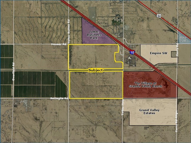
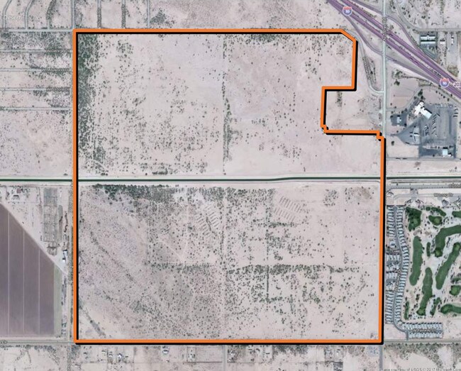
Property Record
W Battaglia Dr, Eloy, AZ 85131
Property Detail
W Battaglia Dr
403-23-003D
THAT PRT OF SEC 33-7S-7E LYING S & E OF CAP R/W EXC SE SW THEREOF 274.23 AC
Vacantlandnec
PINAL
UNDESIGNAT
Arizona
A Areas with a 1% annual chance of flooding and a 26% chance of flooding over the life of a 30-year mortgage.
274.23 AC
2024
Pinal County
2025
Phoenix
000000
Phoenix-Mesa-Chandler, AZ
NEARBY LISTINGS FOR SALE OR LEASE
DEMOGRAPHICS near W Battaglia Dr
1 mile
3 mile
5 mile
2024 Total Population
449
9,775
30,029
2029 Population
529
11,676
36,091
Pop Growth 2024-2029
+ 17.82%
+ 19.45%
+ 20.19%
Average Age
42
45
43
2024 Total Households
157
3,950
11,245
HH Growth 2024-2029
+ 17.83%
+ 19.34%
+ 19.99%
Median Household Inc
$48,269
$52,798
$57,806
Avg Household Size
2.90
2.40
2.60
2024 Avg HH Vehicles
2.00
2.00
2.00
Median Home Value
$250,000
$277,757
$270,176
Median Year Built
2000
2003
2003
Nearby Places
Map Layers
Map Styles
 Street
 Aerial
Transit
 Traffic
 Biking
Places
Listings with unknown addresses are not visible on the map
- Restaurants
- Banks
- Shops
- Fitness
- Groceries
SALE & LEASE HISTORY
LISTING DATE
SALE/LEASE

Sep 08, 2017
For Sale
Nov 27, 2017
For Sale
Apr 04, 2017
For Sale
Apr 03, 2017
For Sale
Nearby Properties
Address
Land Use
TOTAL SIZE
Lot Size
Zoning
Address
Land Use
TOTAL SIZE
Lot Size
Zoning
134,131 SF
44.33 AC
Address
Land Use
TOTAL SIZE
Lot Size
Zoning
37,469 SF
20.01 AC
UNDESIGNAT
Address
Land Use
TOTAL SIZE
Lot Size
Zoning
71,361 SF
15.19 AC
Address
Land Use
TOTAL SIZE
Lot Size
Zoning
107,496 SF
20 AC
UNDESIGNAT
Address
Land Use
TOTAL SIZE
Lot Size
Zoning
11,382 SF
13.33 AC
Address
Land Use
TOTAL SIZE
Lot Size
Zoning
27.14 AC
UNDESIGNAT
Address
Land Use
TOTAL SIZE
Lot Size
Zoning
Address
Land Use
TOTAL SIZE
Lot Size
Zoning
26.29 AC
Address
Land Use
TOTAL SIZE
Lot Size
Zoning
36,480 SF
18.12 AC
UNDESIGNAT
Address
Land Use
TOTAL SIZE
Lot Size
Zoning
70,027 SF
9.28 AC
Address
Land Use
TOTAL SIZE
Lot Size
Zoning
16,160 SF
11.88 AC
Address
Land Use
TOTAL SIZE
Lot Size
Zoning
51,979 SF
7.99 AC
UNDESIGNAT
Address
Land Use
TOTAL SIZE
Lot Size
Zoning
28,252 SF
10.35 AC
Address
Land Use
TOTAL SIZE
Lot Size
Zoning
21,800 SF
17.27 AC
UNDESIGNAT
Address
Land Use
TOTAL SIZE
Lot Size
Zoning
24,543 SF
2.28 AC
UNDESIGNAT
Address
Land Use
TOTAL SIZE
Lot Size
Zoning
Address
Land Use
TOTAL SIZE
Lot Size
Zoning
46.81 AC
Address
Land Use
TOTAL SIZE
Lot Size
Zoning
10,000 SF
24.53 AC
Address
Land Use
TOTAL SIZE
Lot Size
Zoning
5,820 SF
1.63 AC
Address
Land Use
TOTAL SIZE
Lot Size
Zoning
352 SF
22.81 AC
UNDESIGNAT
Address
Land Use
TOTAL SIZE
Lot Size
Zoning
60.31 AC
UNDESIGNAT
Address
Land Use
TOTAL SIZE
Lot Size
Zoning
12,722 SF
5.61 AC
GR
Address
Land Use
TOTAL SIZE
Lot Size
Zoning
16,393 SF
116.73 AC
UNDESIGNAT
Address
Land Use
TOTAL SIZE
Lot Size
Zoning
27,639 SF
2.82 AC
UNDESIGNAT
Address
Land Use
TOTAL SIZE
Lot Size
Zoning
8,320 SF
1.20 AC
Address
Land Use
TOTAL SIZE
Lot Size
Zoning
8,988 SF
0.93 AC
Address
Land Use
TOTAL SIZE
Lot Size
Zoning
5,424 SF
0.44 AC
CB1
Address
Land Use
TOTAL SIZE
Lot Size
Zoning
25.95 AC
Address
Land Use
TOTAL SIZE
Lot Size
Zoning
8,453 SF
2.95 AC
CB1
The World's #1 Commercial Real Estate Marketplace
Connect with us
© 2026 CoStar Group
The information above has been obtained from sources believed reliable. While we do not doubt its accuracy we have not verified it and make no guarantee, warranty or representation about it. It is your responsibility to independently confirm its accuracy and completeness. Any projections, opinions, assumptions, or estimates used are for example only and do not represent the current or future performance of the property. The value of this transaction to you depends on tax and other factors which should be evaluated by your tax, financial, and legal advisors. You and your advisors should conduct a careful, independent investigation of the property to determine to your satisfaction the suitability of the property for your needs.