Property Record
Tommy Stalnaker Dr, , GA
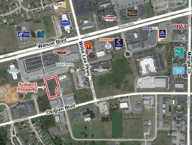

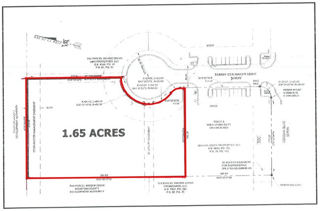

This Property Is For Sale
Property Detail
Tommy Stalnaker Dr
Warner Robins, GA
1.65 ACRES PARCEL B LL 95 LD 5
0W78D0 323000
HOUSTON
Commercialacreage
Georgia
C2
1.65 AC
2025
Perry/Warner Robins
2025
Other Market Areas
021105
NEARBY LISTINGS FOR SALE OR LEASE
DEMOGRAPHICS near Tommy Stalnaker Dr
1 mile
3 mile
5 mile
2025 Total Population
5,647
45,065
110,505
2030 Population
5,994
47,364
115,817
Pop Growth 2025-2030
+ 6.14%
+ 5.10%
+ 4.81%
Average Age
40
39
39
2025 Total Households
2,481
18,141
43,361
HH Growth 2025-2030
+ 6.13%
+ 5.10%
+ 4.85%
Median Household Inc
$68,909
$72,705
$70,493
Avg Household Size
2.20
2.50
2.50
2025 Avg HH Vehicles
2.00
2.00
2.00
Median Home Value
$205,015
$196,708
$195,593
Median Year Built
2001
1995
1992
Nearby Places
Map Layers
Map Styles
 Street
 Aerial
Transit
 Traffic
 Biking
Places
Listings with unknown addresses are not visible on the map
- Restaurants
- Banks
- Shops
- Fitness
- Groceries
Nearby Properties
Address
Land Use
TOTAL SIZE
Lot Size
Zoning
Address
Land Use
TOTAL SIZE
Lot Size
Zoning
503,585 SF
61.05 AC
C-2, WR
Address
Land Use
TOTAL SIZE
Lot Size
Zoning
5,648 SF
49.72 AC
R4
Address
Land Use
TOTAL SIZE
Lot Size
Zoning
18,954 SF
20 AC
C2
Address
Land Use
TOTAL SIZE
Lot Size
Zoning
9,600 SF
24.25 AC
C-H
Address
Land Use
TOTAL SIZE
Lot Size
Zoning
37,908 SF
19.79 AC
C2
Address
Land Use
TOTAL SIZE
Lot Size
Zoning
3,960 SF
22.93 AC
R4
Address
Land Use
TOTAL SIZE
Lot Size
Zoning
61,158 SF
26.31 AC
PUD
Address
Land Use
TOTAL SIZE
Lot Size
Zoning
5,640 SF
28 AC
PDE
Address
Land Use
TOTAL SIZE
Lot Size
Zoning
338,708 SF
28.28 AC
M-2 WR
Address
Land Use
TOTAL SIZE
Lot Size
Zoning
5,640 SF
24 AC
C2
Address
Land Use
TOTAL SIZE
Lot Size
Zoning
21,476 SF
17.41 AC
R4
Address
Land Use
TOTAL SIZE
Lot Size
Zoning
488,964 SF
49.90 AC
C2
Address
Land Use
TOTAL SIZE
Lot Size
Zoning
94,820 SF
18.66 AC
C2
Address
Land Use
TOTAL SIZE
Lot Size
Zoning
223,599 SF
22.40 AC
C2
Address
Land Use
TOTAL SIZE
Lot Size
Zoning
100,500 SF
19.74 AC
R2
Address
Land Use
TOTAL SIZE
Lot Size
Zoning
2,551 SF
17.38 AC
R4 C2
Address
Land Use
TOTAL SIZE
Lot Size
Zoning
100,500 SF
19.64 AC
R2
Address
Land Use
TOTAL SIZE
Lot Size
Zoning
2,080 SF
15.62 AC
R4
Address
Land Use
TOTAL SIZE
Lot Size
Zoning
560 SF
24.73 AC
R4
Address
Land Use
TOTAL SIZE
Lot Size
Zoning
225,751 SF
100 AC
M-1, WR
Address
Land Use
TOTAL SIZE
Lot Size
Zoning
63,274 SF
40.27 AC
C-2, WR
Address
Land Use
TOTAL SIZE
Lot Size
Zoning
132,850 SF
24.05 AC
C2
Address
Land Use
TOTAL SIZE
Lot Size
Zoning
234,239 SF
24.71 AC
C2
Address
Land Use
TOTAL SIZE
Lot Size
Zoning
158,300 SF
29.99 AC
R1
Address
Land Use
TOTAL SIZE
Lot Size
Zoning
76,751 SF
26.32 AC
R1
Address
Land Use
TOTAL SIZE
Lot Size
Zoning
125,550 SF
9.82 AC
C2
Address
Land Use
TOTAL SIZE
Lot Size
Zoning
87,058 SF
8.83 AC
C2
Address
Land Use
TOTAL SIZE
Lot Size
Zoning
62,173 SF
17.70 AC
C2
Address
Land Use
TOTAL SIZE
Lot Size
Zoning
2,231 SF
11.48 AC
C2
Address
Land Use
TOTAL SIZE
Lot Size
Zoning
5,320 SF
15.47 AC
R-4
The World's #1 Commercial Real Estate Marketplace
Connect with us
© 2026 CoStar Group
The information above has been obtained from sources believed reliable. While we do not doubt its accuracy we have not verified it and make no guarantee, warranty or representation about it. It is your responsibility to independently confirm its accuracy and completeness. Any projections, opinions, assumptions, or estimates used are for example only and do not represent the current or future performance of the property. The value of this transaction to you depends on tax and other factors which should be evaluated by your tax, financial, and legal advisors. You and your advisors should conduct a careful, independent investigation of the property to determine to your satisfaction the suitability of the property for your needs.