Property Record
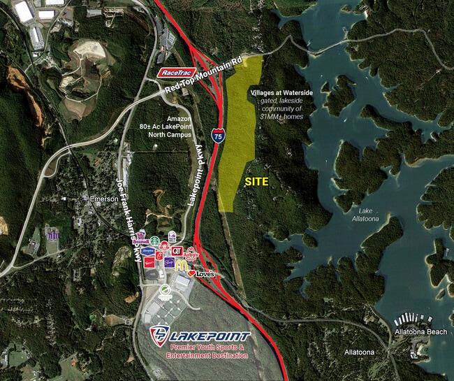
Top Mountain Rd Red, Cartersville, GA 30121


Property Detail
Top Mountain Rd Red
E010-0001-002
LL 720 LD 21 VINYARD PARK
Commercialacreage
BARTOW
IN
Georgia
B and X Area of moderate flood hazard, usually the area between the limits of the 100-year and 500-year floods.
153.48 AC
2025
Bartow County
2025
Atlanta
960403
Atlanta-Sandy Springs-Roswell, GA
NEARBY LISTINGS FOR SALE OR LEASE
DEMOGRAPHICS near Top Mountain Rd Red
1 mile
3 mile
5 mile
2025 Total Population
291
4,589
35,875
2030 Population
314
4,936
38,474
Pop Growth 2025-2030
+ 7.90%
+ 7.56%
+ 7.24%
Average Age
45
42
41
2025 Total Households
113
1,683
13,345
HH Growth 2025-2030
+ 7.96%
+ 7.61%
+ 7.21%
Median Household Inc
$74,999
$78,451
$83,483
Avg Household Size
2.50
2.60
2.60
2025 Avg HH Vehicles
2.00
2.00
2.00
Median Home Value
$225,000
$290,384
$324,285
Median Year Built
1984
1989
1991
Nearby Places
Map Layers
Map Styles
 Street
 Aerial
Layers
 Traffic
 Biking
Places
Listings with unknown addresses are not visible on the map
- Restaurants
- Banks
- Shops
- Fitness
- Groceries
SALE & LEASE HISTORY
LISTING DATE
SALE/LEASE

May 01, 2018
For Sale
Feb 23, 2023
For Sale
Nearby Properties
Address
Land Use
TOTAL SIZE
Lot Size
Zoning
Address
Land Use
TOTAL SIZE
Lot Size
Zoning
Address
Land Use
TOTAL SIZE
Lot Size
Zoning
175,810 SF
53.35 AC
Address
Land Use
TOTAL SIZE
Lot Size
Zoning
127,175 SF
55.52 AC
Address
Land Use
TOTAL SIZE
Lot Size
Zoning
77,214 SF
15.74 AC
Address
Land Use
TOTAL SIZE
Lot Size
Zoning
171,050 SF
6.71 AC
Address
Land Use
TOTAL SIZE
Lot Size
Zoning
313,245 SF
30.15 AC
Address
Land Use
TOTAL SIZE
Lot Size
Zoning
3,320 SF
78.23 AC
Address
Land Use
TOTAL SIZE
Lot Size
Zoning
83,061 SF
46.95 AC
IN
Address
Land Use
TOTAL SIZE
Lot Size
Zoning
Address
Land Use
TOTAL SIZE
Lot Size
Zoning
96,951 SF
30.01 AC
IN
Address
Land Use
TOTAL SIZE
Lot Size
Zoning
201,427 SF
12.81 AC
Address
Land Use
TOTAL SIZE
Lot Size
Zoning
75,540 SF
2.12 AC
Address
Land Use
TOTAL SIZE
Lot Size
Zoning
52,080 SF
25.11 AC
Address
Land Use
TOTAL SIZE
Lot Size
Zoning
14.09 AC
Address
Land Use
TOTAL SIZE
Lot Size
Zoning
11,945 SF
12.96 AC
Address
Land Use
TOTAL SIZE
Lot Size
Zoning
12,112 SF
5.14 AC
Address
Land Use
TOTAL SIZE
Lot Size
Zoning
199,704 SF
19.32 AC
IN
Address
Land Use
TOTAL SIZE
Lot Size
Zoning
45,045 SF
2.63 AC
Address
Land Use
TOTAL SIZE
Lot Size
Zoning
45,085 SF
32.14 AC
IN
Address
Land Use
TOTAL SIZE
Lot Size
Zoning
39,464 SF
1.61 AC
Address
Land Use
TOTAL SIZE
Lot Size
Zoning
560.48 AC
M1
Address
Land Use
TOTAL SIZE
Lot Size
Zoning
1.43 AC
IN
Address
Land Use
TOTAL SIZE
Lot Size
Zoning
600 SF
176.27 AC
A1
Address
Land Use
TOTAL SIZE
Lot Size
Zoning
2,048 SF
Address
Land Use
TOTAL SIZE
Lot Size
Zoning
22.48 AC
Address
Land Use
TOTAL SIZE
Lot Size
Zoning
Address
Land Use
TOTAL SIZE
Lot Size
Zoning
103,850 SF
7.15 AC
A1
Address
Land Use
TOTAL SIZE
Lot Size
Zoning
40.41 AC
Address
Land Use
TOTAL SIZE
Lot Size
Zoning
10,012 SF
19.96 AC
IN
The World's #1 Commercial Real Estate Marketplace
Connect with us
© 2026 CoStar Group
The information above has been obtained from sources believed reliable. While we do not doubt its accuracy we have not verified it and make no guarantee, warranty or representation about it. It is your responsibility to independently confirm its accuracy and completeness. Any projections, opinions, assumptions, or estimates used are for example only and do not represent the current or future performance of the property. The value of this transaction to you depends on tax and other factors which should be evaluated by your tax, financial, and legal advisors. You and your advisors should conduct a careful, independent investigation of the property to determine to your satisfaction the suitability of the property for your needs.