Property Record
Tower Rd, Waleska, GA 30183
NEARBY LISTINGS FOR SALE OR LEASE
-
-
View all Waleska listings for sale on LoopNet.com
Property Detail
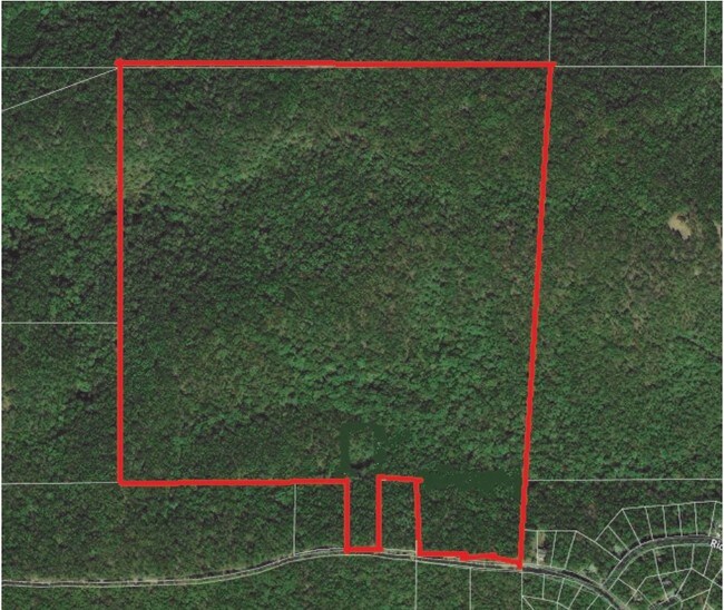
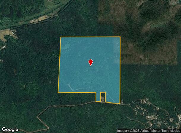
Tower Rd
022N07-00000-005-000-0000
LL 310 22ND D
Agriculturalland
Cherokee
X
Georgia
13057C0130E
160.34 AC
2025
Cherokee County
2025
Atlanta
090202
Atlanta-Sandy Springs-Roswell, GA
DEMOGRAPHICS near Tower Rd
1 Mile
3 Mile
5 Mile
2024 Total Population
565
4,897
8,052
2029 Population
660
5,695
9,294
Pop Growth 2024-2029
+ 16.81%
+ 16.30%
+ 15.42%
Average Age
49
48
46
2024 Total Households
234
1,938
2,996
HH Growth 2024-2029
+ 17.09%
+ 16.67%
+ 15.82%
Median Household Inc
$98,957
$100,117
$95,863
Avg Household Size
2.40
2.40
2.50
2024 Avg HH Vehicles
2.00
2.00
2.00
Median Home Value
$485,999
$467,357
$429,559
Median Year Built
2001
2001
1999
Nearby Places
Map Layers
Map Styles
 Street
 Aerial
- Restaurants
- Banks
- Shops
- Fitness
- Groceries
SALE & LEASE HISTORY
LISTING DATE
SALE/LEASE

Aug 21, 2019
For Sale
Nearby Properties
Address
Land Use
TOTAL SIZE
Lot Size
Zoning
Address
Land Use
TOTAL SIZE
Lot Size
Zoning
26,762 SF
PUD
Address
Land Use
TOTAL SIZE
Lot Size
Zoning
415.87 AC
AG
Address
Land Use
TOTAL SIZE
Lot Size
Zoning
320 AC
AG
Address
Land Use
TOTAL SIZE
Lot Size
Zoning
1,748.42 AC
PUD
Address
Land Use
TOTAL SIZE
Lot Size
Zoning
5,940 SF
226.83 AC
AG
Address
Land Use
TOTAL SIZE
Lot Size
Zoning
174.36 AC
A1
Address
Land Use
TOTAL SIZE
Lot Size
Zoning
544.40 AC
AG
Address
Land Use
TOTAL SIZE
Lot Size
Zoning
1,232 SF
87.31 AC
AG
Address
Land Use
TOTAL SIZE
Lot Size
Zoning
4,968 SF
123.83 AC
AG
Address
Land Use
TOTAL SIZE
Lot Size
Zoning
83.86 AC
AG
Address
Land Use
TOTAL SIZE
Lot Size
Zoning
67 AC
AG
Address
Land Use
TOTAL SIZE
Lot Size
Zoning
86.63 AC
AG
Address
Land Use
TOTAL SIZE
Lot Size
Zoning
87.21 AC
AG
Address
Land Use
TOTAL SIZE
Lot Size
Zoning
9,353 SF
4.49 AC
PUD
Address
Land Use
TOTAL SIZE
Lot Size
Zoning
76 AC
AG
Address
Land Use
TOTAL SIZE
Lot Size
Zoning
124.81 AC
AG
Address
Land Use
TOTAL SIZE
Lot Size
Zoning
126.78 AC
AG
Address
Land Use
TOTAL SIZE
Lot Size
Zoning
174.61 AC
AG
Address
Land Use
TOTAL SIZE
Lot Size
Zoning
218.61 AC
AG
Address
Land Use
TOTAL SIZE
Lot Size
Zoning
512 AC
AG
Address
Land Use
TOTAL SIZE
Lot Size
Zoning
170.16 AC
AG
Address
Land Use
TOTAL SIZE
Lot Size
Zoning
171.66 AC
AG
Address
Land Use
TOTAL SIZE
Lot Size
Zoning
2,824 SF
53.53 AC
AG
Address
Land Use
TOTAL SIZE
Lot Size
Zoning
3,018 SF
41.99 AC
AG
Address
Land Use
TOTAL SIZE
Lot Size
Zoning
53.77 AC
AG
Address
Land Use
TOTAL SIZE
Lot Size
Zoning
500 AC
AG
Address
Land Use
TOTAL SIZE
Lot Size
Zoning
43.19 AC
AG
Address
Land Use
TOTAL SIZE
Lot Size
Zoning
114.40 AC
AG
Address
Land Use
TOTAL SIZE
Lot Size
Zoning
67.55 AC
AG
The World's #1 Commercial Real Estate Marketplace
Connect with us
© 2026 CoStar Group
The information above has been obtained from sources believed reliable. While we do not doubt its accuracy we have not verified it and make no guarantee, warranty or representation about it. It is your responsibility to independently confirm its accuracy and completeness. Any projections, opinions, assumptions, or estimates used are for example only and do not represent the current or future performance of the property. The value of this transaction to you depends on tax and other factors which should be evaluated by your tax, financial, and legal advisors. You and your advisors should conduct a careful, independent investigation of the property to determine to your satisfaction the suitability of the property for your needs.