Property Record
2378 Highway 123, Toccoa, GA 30577


NEARBY LISTINGS FOR SALE OR LEASE
-
-
View all Toccoa listings for sale on LoopNet.com
Property Detail
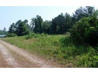
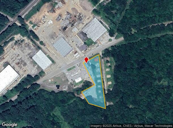
2378 Highway 123
041-013
8300 - Primary - Sf
Publicstorage
TRACT 5 HWY 123
X
Stephens
13257C0110D
Georgia
2025
2.31 AC
2025
Georgia Northeast
970202
Other Market Areas
2,560 SF
Toccoa, GA
DEMOGRAPHICS near 2378 Highway 123
1 Mile
3 Mile
5 Mile
2024 Total Population
126
8,983
17,638
2029 Population
130
9,167
18,088
Pop Growth 2024-2029
+ 3.17%
+ 2.05%
+ 2.55%
Average Age
44
42
42
2024 Total Households
52
3,688
7,067
HH Growth 2024-2029
+ 3.85%
+ 1.84%
+ 2.52%
Median Household Inc
$53,750
$49,589
$47,494
Avg Household Size
2.40
2.40
2.40
2024 Avg HH Vehicles
2.00
2.00
2.00
Median Home Value
$233,333
$175,868
$153,991
Median Year Built
1983
1979
1980
Nearby Places
Map Layers
Map Styles
 Street
 Aerial
- Restaurants
- Banks
- Shops
- Fitness
- Groceries
PUBLIC TRANSPORTATION
COMMUTER RAIL
Toccoa Amtrak Station (Crescent - Amtrak)
DRIVE
WALK
Distance
Toccoa Amtrak Station (Crescent - Amtrak)
4 min
3.4 mi
Freight Ports
Georgia Ports - Savannah
DRIVE
WALK
Distance
Georgia Ports - Savannah
303 min
248.3 mi
SALE & LEASE HISTORY
LISTING DATE
SALE/LEASE

Jul 02, 2018
For Sale
Nearby Properties
Address
Land Use
TOTAL SIZE
Lot Size
Zoning
Address
Land Use
TOTAL SIZE
Lot Size
Zoning
3.47 AC
CI
Address
Land Use
TOTAL SIZE
Lot Size
Zoning
391,121 SF
62.73 AC
CG
Address
Land Use
TOTAL SIZE
Lot Size
Zoning
52,140 SF
115.88 AC
CG
Address
Land Use
TOTAL SIZE
Lot Size
Zoning
6.56 AC
CG
Address
Land Use
TOTAL SIZE
Lot Size
Zoning
5,120 SF
154.08 AC
CG
Address
Land Use
TOTAL SIZE
Lot Size
Zoning
4.24 AC
M-I
Address
Land Use
TOTAL SIZE
Lot Size
Zoning
49,548 SF
14.80 AC
R-II
Address
Land Use
TOTAL SIZE
Lot Size
Zoning
Address
Land Use
TOTAL SIZE
Lot Size
Zoning
66,517 SF
10.48 AC
R-II
Address
Land Use
TOTAL SIZE
Lot Size
Zoning
13,568 SF
7.50 AC
B-II
Address
Land Use
TOTAL SIZE
Lot Size
Zoning
110,718 SF
10.14 AC
B-II
Address
Land Use
TOTAL SIZE
Lot Size
Zoning
Address
Land Use
TOTAL SIZE
Lot Size
Zoning
11,600 SF
199.79 AC
A-I
Address
Land Use
TOTAL SIZE
Lot Size
Zoning
Address
Land Use
TOTAL SIZE
Lot Size
Zoning
11,914 SF
2.04 AC
B-I
Address
Land Use
TOTAL SIZE
Lot Size
Zoning
19,970 SF
0.61 AC
B-III
Address
Land Use
TOTAL SIZE
Lot Size
Zoning
74,957 SF
13.98 AC
B-II
Address
Land Use
TOTAL SIZE
Lot Size
Zoning
375 AC
LI
Address
Land Use
TOTAL SIZE
Lot Size
Zoning
51,660 SF
2.39 AC
R-IA
Address
Land Use
TOTAL SIZE
Lot Size
Zoning
16,872 SF
2.53 AC
B-II
Address
Land Use
TOTAL SIZE
Lot Size
Zoning
43,350 SF
6.43 AC
B-I
Address
Land Use
TOTAL SIZE
Lot Size
Zoning
131,290 SF
20.92 AC
CI
Address
Land Use
TOTAL SIZE
Lot Size
Zoning
2,080 SF
5.61 AC
R-II
Address
Land Use
TOTAL SIZE
Lot Size
Zoning
Address
Land Use
TOTAL SIZE
Lot Size
Zoning
Address
Land Use
TOTAL SIZE
Lot Size
Zoning
1,960 SF
5.99 AC
R-II
Address
Land Use
TOTAL SIZE
Lot Size
Zoning
15,169 SF
1.56 AC
R-IA
Address
Land Use
TOTAL SIZE
Lot Size
Zoning
2,212 SF
5.24 AC
R-III
Address
Land Use
TOTAL SIZE
Lot Size
Zoning
11,568 SF
10.14 AC
CG
Address
Land Use
TOTAL SIZE
Lot Size
Zoning
12,292 SF
11.01 AC
R-III
The World's #1 Commercial Real Estate Marketplace
Connect with us
© 2025 CoStar Group
The information above has been obtained from sources believed reliable. While we do not doubt its accuracy we have not verified it and make no guarantee, warranty or representation about it. It is your responsibility to independently confirm its accuracy and completeness. Any projections, opinions, assumptions, or estimates used are for example only and do not represent the current or future performance of the property. The value of this transaction to you depends on tax and other factors which should be evaluated by your tax, financial, and legal advisors. You and your advisors should conduct a careful, independent investigation of the property to determine to your satisfaction the suitability of the property for your needs.