Property Record
18555 Highway 72, Rogersville, AL 35652
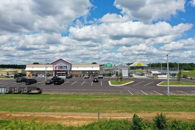

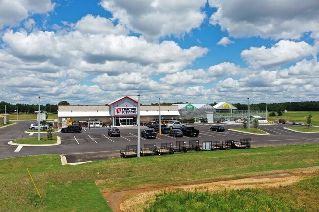
Property Detail
18555 Highway 72
20-02-03-0-000-005.012
9.7 AC/C IN W/2 OF NE-SE SEC 3 T3S R7W
Storesoffices
LAUDERDALE
B and X Area of moderate flood hazard, usually the area between the limits of the 100-year and 500-year floods.
Alabama
2025
9.70 AC
2025
Alabama North Area
011802
Other Market Areas
23,752 SF
Florence-Muscle Shoals, AL
NEARBY LISTINGS FOR SALE OR LEASE
-
-
View all Rogersville listings for sale on LoopNet.com
DEMOGRAPHICS near 18555 Highway 72
1 mile
3 mile
5 mile
2025 Total Population
447
4,261
8,150
2030 Population
475
4,629
8,878
Pop Growth 2025-2030
+ 6.26%
+ 8.64%
+ 8.93%
Average Age
46
45
45
2025 Total Households
198
1,855
3,504
HH Growth 2025-2030
+ 7.07%
+ 9.06%
+ 9.33%
Median Household Inc
$67,200
$70,059
$71,411
Avg Household Size
2.30
2.30
2.30
2025 Avg HH Vehicles
2.00
2.00
2.00
Median Home Value
$257,291
$293,832
$296,072
Median Year Built
1980
1992
1992
Nearby Places
Map Layers
Map Styles
 Street
 Aerial
Transit
 Traffic
 Biking
Places
Listings with unknown addresses are not visible on the map
- Restaurants
- Banks
- Shops
- Fitness
- Groceries
PUBLIC TRANSPORTATION
AIRPORT
Huntsville International-Carl T Jones Field
Drive
Walk
Distance
Huntsville International-Carl T Jones Field
52 min
39.9 mi
Freight Ports
Port of Mobile
Drive
Walk
Distance
Port of Mobile
401 min
364.7 mi
SALE & LEASE HISTORY
LISTING DATE
SALE/LEASE

Nov 14, 2023
For Sale
Jun 13, 2024
For Sale
Jun 11, 2024
For Sale
Feb 05, 2024
For Sale
Nearby Properties
Address
Land Use
TOTAL SIZE
Lot Size
Zoning
Address
Land Use
TOTAL SIZE
Lot Size
Zoning
5,221 SF
15.90 AC
Address
Land Use
TOTAL SIZE
Lot Size
Zoning
2,160 SF
9.39 AC
Address
Land Use
TOTAL SIZE
Lot Size
Zoning
Address
Land Use
TOTAL SIZE
Lot Size
Zoning
28,812 SF
6.80 AC
Address
Land Use
TOTAL SIZE
Lot Size
Zoning
18,839 SF
3.48 AC
Address
Land Use
TOTAL SIZE
Lot Size
Zoning
11,875 SF
13 AC
Address
Land Use
TOTAL SIZE
Lot Size
Zoning
40,175 SF
8 AC
Address
Land Use
TOTAL SIZE
Lot Size
Zoning
1,040 SF
22.31 AC
Address
Land Use
TOTAL SIZE
Lot Size
Zoning
22,572 SF
2.30 AC
Address
Land Use
TOTAL SIZE
Lot Size
Zoning
8,718 SF
2.88 AC
Address
Land Use
TOTAL SIZE
Lot Size
Zoning
6.78 AC
Address
Land Use
TOTAL SIZE
Lot Size
Zoning
4,930 SF
0.76 AC
Address
Land Use
TOTAL SIZE
Lot Size
Zoning
1,976 SF
4.22 AC
Address
Land Use
TOTAL SIZE
Lot Size
Zoning
182 AC
Address
Land Use
TOTAL SIZE
Lot Size
Zoning
6,300 SF
3.18 AC
Address
Land Use
TOTAL SIZE
Lot Size
Zoning
172 AC
Address
Land Use
TOTAL SIZE
Lot Size
Zoning
6,840 SF
3.22 AC
Address
Land Use
TOTAL SIZE
Lot Size
Zoning
36,864 SF
10 AC
Address
Land Use
TOTAL SIZE
Lot Size
Zoning
5,280 SF
2.34 AC
Address
Land Use
TOTAL SIZE
Lot Size
Zoning
2,776 SF
0.53 AC
Address
Land Use
TOTAL SIZE
Lot Size
Zoning
3,438 SF
1.38 AC
Address
Land Use
TOTAL SIZE
Lot Size
Zoning
3,494 SF
1.95 AC
Address
Land Use
TOTAL SIZE
Lot Size
Zoning
6,800 SF
0.96 AC
Address
Land Use
TOTAL SIZE
Lot Size
Zoning
780 SF
4 AC
Address
Land Use
TOTAL SIZE
Lot Size
Zoning
26,752 SF
2.25 AC
Address
Land Use
TOTAL SIZE
Lot Size
Zoning
6,874 SF
6.72 AC
Address
Land Use
TOTAL SIZE
Lot Size
Zoning
2,375 SF
1.49 AC
Address
Land Use
TOTAL SIZE
Lot Size
Zoning
19,733 SF
1.35 AC
Address
Land Use
TOTAL SIZE
Lot Size
Zoning
3,900 SF
2.49 AC
The World's #1 Commercial Real Estate Marketplace
Connect with us
© 2026 CoStar Group
The information above has been obtained from sources believed reliable. While we do not doubt its accuracy we have not verified it and make no guarantee, warranty or representation about it. It is your responsibility to independently confirm its accuracy and completeness. Any projections, opinions, assumptions, or estimates used are for example only and do not represent the current or future performance of the property. The value of this transaction to you depends on tax and other factors which should be evaluated by your tax, financial, and legal advisors. You and your advisors should conduct a careful, independent investigation of the property to determine to your satisfaction the suitability of the property for your needs.