Property Record
Traditions Pkwy, Dayton, NV 89403

NEARBY LISTINGS FOR SALE OR LEASE
Property Detail
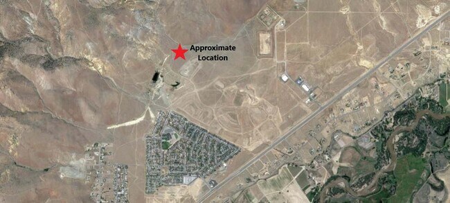
Traditions Pkwy
Reno, NV
Traditions Village 1
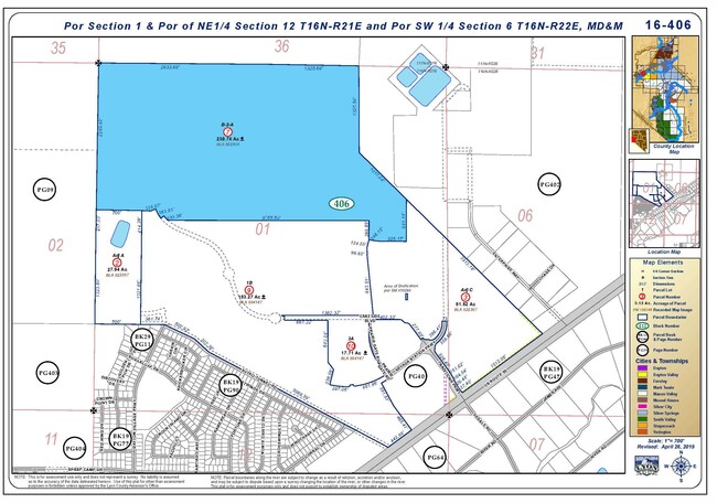
016-406-07
Lyon
Residentialacreage
Nevada
X
b-2-a
32019C0289F
230.76 AC
2026
Lyon County
2025
Reno/Sparks
960304
DEMOGRAPHICS near Traditions Pkwy
1 mile
3 mile
5 mile
2024 Total Population
2,543
11,676
16,734
2029 Population
2,751
12,703
18,239
Pop Growth 2024-2029
+ 8.18%
+ 8.80%
+ 8.99%
Average Age
39
44
44
2024 Total Households
919
4,598
6,546
HH Growth 2024-2029
+ 8.16%
+ 8.79%
+ 8.92%
Median Household Inc
$87,565
$79,608
$80,348
Avg Household Size
2.70
2.50
2.50
2024 Avg HH Vehicles
2.00
2.00
2.00
Median Home Value
$278,973
$360,842
$362,563
Median Year Built
1997
1998
2000
Nearby Places
Map Layers
Map Styles
 Street
 Aerial
Transit
 Traffic
 Biking
Places
Listings with unknown addresses are not visible on the map
- Restaurants
- Banks
- Shops
- Fitness
- Groceries
PUBLIC TRANSPORTATION
AIRPORT
Reno/Tahoe International
Drive
Walk
Distance
Reno/Tahoe International
72 min
44.2 mi
Freight Ports
Port of Stockton
Drive
Walk
Distance
Port of Stockton
241 min
165.9 mi
SALE & LEASE HISTORY
LISTING DATE
SALE/LEASE

Aug 21, 2023
For Sale
Nearby Properties
Address
Land Use
TOTAL SIZE
Lot Size
Zoning
Address
Land Use
TOTAL SIZE
Lot Size
Zoning
9,804 SF
3.31 AC
MFR
Address
Land Use
TOTAL SIZE
Lot Size
Zoning
64,532 SF
7 AC
C2
Address
Land Use
TOTAL SIZE
Lot Size
Zoning
47,941 SF
10.33 AC
MULT
Address
Land Use
TOTAL SIZE
Lot Size
Zoning
1,579 SF
6.73 AC
C2
Address
Land Use
TOTAL SIZE
Lot Size
Zoning
9,600 SF
4.50 AC
C2
Address
Land Use
TOTAL SIZE
Lot Size
Zoning
5,760 SF
3 AC
M1
Address
Land Use
TOTAL SIZE
Lot Size
Zoning
19,934 SF
2.18 AC
C2
Address
Land Use
TOTAL SIZE
Lot Size
Zoning
20,100 SF
6.58 AC
C1
Address
Land Use
TOTAL SIZE
Lot Size
Zoning
21,119 SF
3.10 AC
C2
Address
Land Use
TOTAL SIZE
Lot Size
Zoning
15,264 SF
1.60 AC
C2
Address
Land Use
TOTAL SIZE
Lot Size
Zoning
35,000 SF
3 AC
M1
Address
Land Use
TOTAL SIZE
Lot Size
Zoning
3,600 SF
56.13 AC
MULT
Address
Land Use
TOTAL SIZE
Lot Size
Zoning
21,349 SF
1.82 AC
C2
Address
Land Use
TOTAL SIZE
Lot Size
Zoning
17.04 AC
C2
Address
Land Use
TOTAL SIZE
Lot Size
Zoning
672 SF
5.37 AC
C2
Address
Land Use
TOTAL SIZE
Lot Size
Zoning
42.04 AC
C2
Address
Land Use
TOTAL SIZE
Lot Size
Zoning
29,290 SF
2 AC
M1
Address
Land Use
TOTAL SIZE
Lot Size
Zoning
15,773 SF
1.80 AC
NR1
Address
Land Use
TOTAL SIZE
Lot Size
Zoning
18,456 SF
1.35 AC
C2
Address
Land Use
TOTAL SIZE
Lot Size
Zoning
37,200 SF
5.55 AC
M1
Address
Land Use
TOTAL SIZE
Lot Size
Zoning
15,543 SF
1.44 AC
C2
Address
Land Use
TOTAL SIZE
Lot Size
Zoning
4,644 SF
1.18 AC
C2
Address
Land Use
TOTAL SIZE
Lot Size
Zoning
4,537 SF
35.19 AC
RR2T
Address
Land Use
TOTAL SIZE
Lot Size
Zoning
16,256 SF
2.26 AC
C2
Address
Land Use
TOTAL SIZE
Lot Size
Zoning
12.39 AC
C2
Address
Land Use
TOTAL SIZE
Lot Size
Zoning
5.67 AC
C2
Address
Land Use
TOTAL SIZE
Lot Size
Zoning
7,380 SF
1.07 AC
MULT
Address
Land Use
TOTAL SIZE
Lot Size
Zoning
8.86 AC
MULT
Address
Land Use
TOTAL SIZE
Lot Size
Zoning
3,814 SF
4.98 AC
RR3
The World's #1 Commercial Real Estate Marketplace
Connect with us
© 2026 CoStar Group
The information above has been obtained from sources believed reliable. While we do not doubt its accuracy we have not verified it and make no guarantee, warranty or representation about it. It is your responsibility to independently confirm its accuracy and completeness. Any projections, opinions, assumptions, or estimates used are for example only and do not represent the current or future performance of the property. The value of this transaction to you depends on tax and other factors which should be evaluated by your tax, financial, and legal advisors. You and your advisors should conduct a careful, independent investigation of the property to determine to your satisfaction the suitability of the property for your needs.